Raised beach

A raised beach, marine terrace, coastal terrace,[1] or perched coastline is a relatively flat, horizontal or gently inclined surface of marine origin,[2] mostly an old abrasion platform which has been lifted out of the sphere of wave activity (sometimes called "tread"). Thus, it lies above or under the current sea level, depending on the time of its formation.[3][4] It is bounded by a steeper ascending slope on the landward side and a steeper descending slope on the seaward side[2] (sometimes called "riser"). Due to its generally flat shape it is often used for anthropogenic structures such as settlements and infrastructure.[3]
A raised beach is an emergent coastal landform. Raised beaches and marine terraces are beaches or wave-cut platforms raised above the shoreline by a relative fall in the sea level.[5]
Around the world, a combination of tectonic coastal uplift and Quaternary sea-level fluctuations has resulted in the formation of marine terrace sequences, most of which were formed during separate interglacial highstands that can be correlated to marine isotope stages (MIS).[6]
A marine terrace commonly retains a shoreline angle or inner edge, the slope inflection between the marine abrasion platform and the associated paleo sea-cliff. The shoreline angle represents the maximum shoreline of a transgression and therefore a paleo-sea level.
Morphology

The platform of a marine terrace usually has a gradient between 1°–5° depending on the former tidal range with, commonly, a linear to concave profile. The width is quite variable, reaching up to 1,000 metres (3,300 ft), and seems to differ between the northern and southern hemispheres.[9] The cliff faces that delimit the platform can vary in steepness depending on the relative roles of marine and subaerial processes.[10] At the intersection of the former shore (wave-cut/abrasion-) platform and the rising cliff face the platform commonly retains a shoreline angle or inner edge (notch) that indicates the location of the shoreline at the time of maximum sea ingression and therefore a paleo-sea level.[11] Sub-horizontal platforms usually terminate in a low tide cliff, and it is believed that the occurrence of these platforms depends on tidal activity.[10] Marine terraces can extend for several tens of kilometers parallel to the coast.[3]
Older terraces are covered by marine and/or alluvial or colluvial materials while the uppermost terrace levels usually are less well preserved.[12] While marine terraces in areas of relatively rapid uplift rates (> 1 mm/year) can often be correlated to individual interglacial periods or stages, those in areas of slower uplift rates may have a polycyclic origin with stages of returning sea levels following periods of exposure to weathering.[2]
Marine terraces can be covered by a wide variety of soils with complex histories and different ages. In protected areas, allochtonous sandy parent materials from tsunami deposits may be found. Common soil types found on marine terraces include planosols and solonetz.[13]
Formation
It is now widely thought that marine terraces are formed during the separated highstands of interglacial stages correlated to marine isotope stages (MIS).[14][15][16][17][18]
Causes
The formation of marine terraces is controlled by changes in environmental conditions and by tectonic activity during recent geological times. Changes in climatic conditions have led to eustatic sea-level oscillations and isostatic movements of the Earth’s crust, especially with the changes between glacial and interglacial periods.
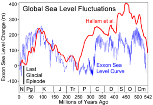
Processes of eustasy lead to glacioeustatic sea level fluctuations due to changes of the water volume in the oceans and hence to regressions and transgressions of the shoreline. At times of maximum glacial extent during the last glacial period, the sea level was about 100 metres (330 ft) lower compared to today. Eustatic sea level changes can also be caused by changes in the void volume of the oceans, either through sedimento-eustasy or tectono-eustasy.[19]
Processes of isostasy involve the uplift of continental crusts along with their shorelines. Today, the process of glacial isostatic adjustment mainly applies to Pleistocene glaciated areas.[19] In Scandinavia, for instance, the present rate of uplift reaches up to 10 millimetres (0.39 in)/year.[20]
In general, eustatic marine terraces were formed during separate sea level highstands of interglacial stages[19][21] and can be correlated to marine oxygene isotopic stages (MIS).[22][23] Glacioisostatic marine terraces were mainly created during stillstands of the isostatic uplift.[19] When eustasy was the main factor for the formation of marine terraces, derived sea level fluctuations can indicate former climate changes. This conclusion has to be treated with care, as isostatic adjustments and tectonic activities can be extensively overcompensated by a eustatic sea level rise. Thus, in areas of both eustatic and isostatic or tectonic influences, the course of the relative sea level curve can be complicated.[24] Hence, most of today's marine terrace sequences were formed by a combination of tectonic coastal uplift and Quaternary sea level fluctuations.
Jerky tectonic uplifts can also lead to marked terrace steps while smooth relative sea level changes may not result in obvious terraces, and their formations are often not referred to as marine terraces.[11]
Processes
Marine terraces often result from marine erosion along rocky coast lines[2] in temperate regions due to wave attack and sediment carried in the waves. Erosion also takes place in connection with weathering and cavitation. The speed of erosion is highly dependent on the shoreline material (hardness of rock[10]), the bathymetry, and the bedrock properties and can be between only a few millimeters per year for granitic rocks and more than 10 metres (33 ft) per year for volcanic ejecta.[10][25] The retreat of the sea cliff generates a shore (wave-cut/abrasion-) platform through the process of abrasion. A relative change of the sea level leads to regressions or transgressions and eventually forms another terrace (marine-cut terrace) at a different altitude while notches in the cliff face indicate short stillstands.[25]
It is believed that the terrace gradient increases with tidal range and decreases with rock resistance. In addition, the relationship between terrace width and the strength of the rock is inverse, and higher rates of uplift and subsidence as well as a higher slope of the hinterland increases the number of terraces formed during a certain time.[26]
Furthermore, shore platforms are formed by denudation and marine-built terraces arise from accumulations of materials removed by shore erosion.[2] Thus a marine terrace can be formed by both erosion and accumulation. However, there is an ongoing debate about the roles of wave erosion and weathering in the formation of shore platforms.[10]
Reef flats or uplifted coral reefs are another kind of marine terrace found in intertropical regions. They are a result of biological activity, shoreline advance and accumulation of reef materials.[2]
While a terrace sequence can date back hundreds of thousands of years, its degradation is a rather fast process. On the one hand a deeper transgression of cliffs into the shoreline may completely destroy previous terraces; on the other hand older terraces might be decayed[25] or covered by deposits, colluvia or alluvial fans.[3] Erosion and backwearing of slopes caused by incisive streams play another important role in this degradation process.[25]
Land and sea level history
The total displacement of the shoreline relative to the age of the associated interglacial stage allows calculation of a mean uplift rate or the calculation of eustatic level at a particular time if the uplift is known.
In order to estimate vertical uplift, the eustatic position of the considered paleo sea levels relative to the present one must be known as precisely as possible. Our chronology relies principally on relative dating based on geomorphologic criteria but in all cases we associated the shoreline angle of the marine terraces with numerical ages. The best-represented terrace worldwide is the one correlated to the last interglacial maximum (MISS 5e) (Hearty and Kindler, 1995; Johnson and Libbey, 1997, Pedoja et al., 2006 a,[27] b,[28] c[29]). Age of MISS 5e is arbitrarily fixed to range from 130 to 116 ka (Kukla et al., 2002[30]) but is demonstrated to range from 134 to 113 ka in Hawaii and Barbados (Muhs et al., 2002) with a peak from 128 to 116 ka on tectonically stable coastlines (Muhs, 2002). Older marine terraces well represented in worldwide sequences are those related to MIS 9 (~303-339 ka) and 11 (~362-423 ka) (Imbrie et al., 1984[31]). Compilations show that sea level was 3 ± 3 meters higher during MISS 5e, MIS 9 and 11 than during the present one and –1 ± 1 m to the present one during MIS 7 (Hearty and Kindler, 1995,[32] Zazo, 1999[33]). Consequently, MIS 7 (~180-240 ka; Imbrie et al., 1984) marine terraces are less pronounced and sometimes absent (Zazo, 1999). When the elevations of these terraces are higher than the uncertainties in paleo-eustatic sea level mentioned for the Holocene and Late Pleistocene, these uncertainties have no effect on overall interpretation.
Sequence can also occurs where the accumulation of ice sheets have depressed the land so that when the ice sheets melts the land readjusts with time thus raising the height of the beaches (glacio-isostatic rebound)and in places where co-seismic uplift occur. In the latter case, the terrace are not correlated with sea level highstand even if co-seismic terrace are known only for the Holocene.
Mapping and surveying

For exact interpretations of the morphology extensive datings, surveying and mapping of marine terraces is applied. This includes stereoscopic aerial photographic interpretation (ca. 1 : 10,000 - 25,000[11]), on-site inspections with topographic maps (ca. 1 : 10,000) and analysis of eroded and accumulated material. Moreover, the exact altitude can be determined with an aneroid barometer or preferably with a levelling instrument mounted on a tripod. It should be measured with the accuracy of 1 cm and at about every 50 – 100 m, depending on the topography. In remote areas technics of photogrammetry and tacheometry can be applied.[24]
Correlation and dating
Different methods for dating and correlation of marine terraces can be used and combined.
Correlational dating
The morphostratigraphic approach focuses especially in regions of marine regression on the altitude as the most important criterion to distinguish coast lines of different ages. Moreover, individual marine terraces can be correlated based on their size and continuity. Also paleo-soils as well as glacial, fluvial, eolian and periglacial landforms and sediments may be used to find correlations between terraces.[24] On New Zealand’s North Island, for instance, tephra and loess were used to date and correlate marine terraces.[34] At the terminus advance of former glaciers marine terraces can be correlated by their size, as their width decreases with age due to the slowly thawing glaciers along the coast line.[24]
The lithostratigraphic approach uses typical sequences of sediment and rock strata to prove sea level fluctuations on the basis of an alternation of terrestrial and marine sediments or littoral and shallow marine sediments. Those strata show typical layers of transgressive and regressive patterns.[24] However, an unconformity in the sediment sequence might make this analysis difficult.[35]
The biostratigraphic approach uses remains of organisms which can indicate the age of a marine terrace. For that often mollusc shells, foraminifera or pollen are used. Especially Mollusca can show specific properties depending on their depth of sedimentation. Thus they can be used to estimate former water depths.[24]
Marine terraces are often correlated to marine oxygene isotopic stages (MIS) (e.g. Johnson, M. E.; Libbey, L. K. 1997[22]) and can also be roughly dated using their stratigraphic position.[24]
Direct dating
There are various methods for the direct dating of marine terraces and their related materials including 14C radiocarbon dating, which is the most common one.[36] E.g. this method has been used on the North Island of New Zealand to date several marine terraces.[37] It utilizes terrestrial biogenic materials in coastal sediments such as mollusc shells analyzing the 14C isotope.[24] In some cases dating based on the 230Th/234U ratio was applied though in case of detrital contamination or low uranium concentrations a high resolution dating was found to be difficult.[38] In a study in southern Italy paleomagnetism was used to carry out paleomagnetic datings[39] and luminescence dating (OSL) was used in different studies on the San Andreas Fault[40] and on the Quaternary Eupcheon Fault in South Korea.[41] In the last decennia, the dating of marine terraces has been enhanced since the arrival of terrestrial cosmogenic nuclides method, and particularly through the use of 10Be and 26Al cosmogenic isotopes produced in-situ.[42][43][44] These isotopes record the duration of surface exposure to cosmic rays.[45] and this exposure age reflects the age of abandonment of a marine terrace by the sea.
In order to calculate the eustatic sea level for each dated terrace it is assumed that the eustatic sea-level position corresponding to at least one marine terrace is known and that the uplift rate has remained essentially constant in each section.[2]
Relevance for other research areas
Marine terraces play an important role in the research on tectonics and earthquakes. They may show patterns and rates of tectonic uplift[40][44][46] and thus may be used to estimate the tectonic activity in a certain region.[41] In some cases the exposed secondary landforms can be correlated with known seismic events such as the 1855 Wairarapa earthquake on the Wairarapa Fault near Wellington, New Zealand which produced a 2.7 m uplift.[47] This figure can be estimated from the vertical offset between raised shorelines in the area.[48]
Furthermore, with the knowledge of eustatic sea level fluctuations the speed of isostatic uplift can be estimated[49] and eventually the change of relative sea levels for certain regions can be reconstructed. Thus marine terraces also provide information for the research on climate change and trends in future sea level changes.[10][50]
When analyzing the morphology of marine terraces it must be considered, that both eustasy and isostasy can have an influence on the formation process. This way can be assessed, whether there were changes in sea level or whether tectonic activities took place.
Prominent examples

Raised beaches are found in a wide variety of coast and geodynamical background such as subduction on the pacific coast of South America (Pedoja et al., 2006), of North America, passive margin of the Atlantic coast of South America (Rostami et al., 2000[51]), collision context on the Pacific coast of Kamchatka (Pedoja et al., 2006), Papua New Guinea, New Zealand, Japan (Ota and Yamaguchi, 2004), passive margin of the South China sea coast (Pedoja et al., in press), on west-facing Atlantic coasts, such as Donegal Bay, County Cork and County Kerry in Ireland; Bude, Widemouth Bay, Crackington Haven, Tintagel, Perranporth and St Ives in Cornwall, the Vale of Glamorgan, Gower Peninsula, Pembrokeshire and Cardigan Bay in Wales, the Isle of Jura and Isle of Arran in Scotland, Finistère in Brittany and Galicia in Northern Spain and at Squally Point in Eatonville, Nova Scotia within the Cape Chignecto Provincial Park.
Other important sites include various coasts of New Zealand, e.g. Turakirae Head near Wellington being one of the world’s best and most thoroughly studied examples.[47][48][52] Also along the Cook Strait in New Zealand there is a well-defined sequence of uplifted marine terraces from the late Quaternary at Tongue Point. It features a well preserved lower terrace from the last interglacial, a widely eroded higher terrace from the penultimate interglacial and another still higher terrace, which is nearly completely decayed.[47] Furthermore, on New Zealand’s North Island at the eastern Bay of Plenty a sequence of seven marine terraces has been studied.[12][37]
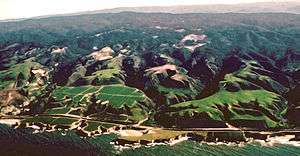
Along many coasts of mainland and islands around the Pacific, marine terraces are typical coastal features. An especially prominent marine terraced coastline can be found north of Santa Cruz, near Davenport, California, where terraces probably have been raised by repeated slip earthquakes on the San Andreas Fault.[40][53] Hans Jenny (pedologist) famously researched the pygmy forests of the Mendocino and Sonoma county marine terraces. The marine terrace's "ecological staircase" of Salt Point State Park is also bound by the San Andreas Fault.
Along the coasts of South America marine terraces are present,[44][54] where the highest ones are situated where plate margins lie above subducted oceanic ridges and the highest and most rapid rates of uplift occur.[7][46] At Cape Laundi, Sumba Island, Indonesia an ancient patch reef can be found at 475 m above sea level as part of a sequence of coral reef terraces with eleven terraces being wider than 100 m.[55] The coral marine terraces at Huon Peninsula, New Guinea, which extend over 80 km and rise over 600 m above present sea level[56] are currently on UNESCO’s tentative list for world heritage sites under the name Houn Terraces - Stairway to the Past.[57]
Other considerable examples include marine terraces rising up to 360 m on some Philippine Islands[58] and along the Mediterranean Coast of North Africa, especially in Tunisia, rising up to 400 m.[59]
Related coastal geography
Uplift can also be registered through tidal notch sequences. Notches are often portrayed as lying at sea level; however notch types actually form a continuum from wave notches formed in quiet conditions at sea level to surf notches formed in more turbulent conditions and as much as 2 m (6.6 ft) above sea level (Pirazzoli et al., 1996 in Rust and Kershaw, 2000[60]). As stated above, there was at least one higher sea level during the Holocene, so that some notches may not contain a tectonic component in their formation.
See also
References
- 1 2 Pinter, N (2010): 'Coastal Terraces, Sealevel, and Active Tectonics' (educational exercise), from http://www.geology.siu.edu/people/pinter/pdf/CoastalExercise.pdf [02/04/2011]
- 1 2 3 4 5 6 7 Pirazzoli, PA (2005a): 'Marine Terraces', in Schwartz, ML (ed) Encyclopedia of Coastal Science. Springer, Dordrecht, pp. 632-633
- 1 2 3 4 5 Strahler AH; Strahler AN (2005): Physische Geographie. Ulmer, Stuttgart, 686 p.
- ↑ Leser, H (ed)(2005): ‚Wörterbuch Allgemeine Geographie. Westermann&Deutscher Taschenbuch Verlag, Braunschweig, 1119 p.
- ↑ http://www.sdnhm.org/research/paleontology/sdshoreline.html
- ↑ Johnson, ME; Libbey, LK (1997). "Global review of Upper Pleistocene (Substage 5e) Rocky Shores: tectonic segregation, substrate variation and biological diversity". Journal of Coastal Research.
- 1 2 Goy, JL; Macharé, J; Ortlieb, L; Zazo, C (1992). "Quaternary shorelines in Southern Peru: a Record of Global Sea-level Fluctuations and Tectonic Uplift in Chala Bay". Quaternary International. 15-16: 9–112.
- ↑ Rosenbloom, NA; Anderson, RS (1994). "'Hillslope and channel evolution in a marine terraced landscape, Santa Cruz, California'". Journal of Geophysical Research. 99 (B7): 14013–14029. Bibcode:1994JGR....9914013R. doi:10.1029/94jb00048.
- ↑ Pethick, J (1984): An Introduction to Coastal Geomorphology. Arnold&Chapman&Hall, New York, 260p.
- 1 2 3 4 5 6 Masselink, G; Hughes, MG (2003): Introduction to Coastal Processes & Geomorphology. Arnold&Oxford University Press Inc., London, 354p.
- 1 2 3 Cantalamessa, G; Di Celma, C (2003). "'Origin and chronology of Pleistocene marine terraces of Isla de la Plata and of flat, gently dipping surfaces of the southern coast of Cabo San Lorenzo (Manabí, Ecuador)'". Journal of South American Earth Sciences. 16: 633–648. doi:10.1016/j.jsames.2003.12.007.
- 1 2 Ota, Y; Hull, AG; Berryman, KR (1991). "'Coseismic Uplift of Holocene Marine Terraces in the Pakarae River Area, Eastern North Island, New Zealand'". Quaternary Research. 35: 331–346. doi:10.1016/0033-5894(91)90049-B.
- ↑ Finkl, CW (2005): 'Coastal Soils' in Schwartz, ML (ed) Encyclopedia of Coastal Science. Springer, Dordrecht, pp. 278-302
- ↑ James, N.P.; Mountjoy, E.W.; Omura, A. (1971). "An early Wisconsin reef Terrace at Barbados, West Indies, and its climatic implications". Geological Society of America Bulletin. 82: 2011–2018. doi:10.1130/0016-7606(1971)82[2011:aewrta]2.0.co;2.
- ↑ Chappell, J (1974). "Geology of coral terraces, Huon Peninsula, New Guinea: a study of Quaternary tectonic movements and sea Level changes". Geological Society of America Bulletin. 85: 553–570. doi:10.1130/0016-7606(1974)85<553:gocthp>2.0.co;2.
- ↑ Bull, W.B., 1985. Correlation of flights of global marine terraces. In: Morisawa M. & Hack J. (Editor), 15th Annual Geomorphology Symposium. Hemel Hempstead, State University of New York at Binghamton, pp. 129-152.
- ↑ Ota, Y (1986). "Marine terraces as reference surfaces in late Quaternary tectonics studies:examples from the Pacific Rim". Royal Society of New Zealand. 24: 357–375.
- ↑ Muhs, D.R.; et al. (1990). "Age Estimates and Uplift Rates for Late Pleistocene Marine Terraces: Southern Oregon Portion of the Cascadia Forearc". Journal of Geophysical Research. 95 (B5): 6685–6688. Bibcode:1990JGR....95.6685M. doi:10.1029/jb095ib05p06685.
- 1 2 3 4 Ahnert, F (1996) – Einführung in die Geomorphologie. Ulmer, Stuttgart, 440 p.
- ↑ Lehmkuhl, F; Römer, W (2007): 'Formenbildung durch endogene Prozesse: Neotektonik', in Gebhardt, H; Glaser, R; Radtke, U; Reuber, P (ed) Geographie, Physische Geographie und Humangeographie. Elsevier, München, pp. 316-320
- ↑ James, NP; Mountjoy, EW; Omura, A (1971). "'An Early Wisconsin Reef Terrace at Barbados, West Indies, and ist Climatic Implications'". Geological Society of America Bulletin. 82: 2011–2018. doi:10.1130/0016-7606(1971)82[2011:AEWRTA]2.0.CO;2.
- 1 2 Johnson, ME; Libbey, LK (1997). "Global Review of Upper Pleistocene (Substage 5e) Rocky Shores: Tectonic Segregation, Substrate Variation, and Biological Diversity". Journal of Coastal Research. 13 (2): 297–307.
- ↑ Muhs, D; Kelsey, H; Miller, G; Kennedy, G; Whelan, J; McInelly, G (1990). "'Age Estimates and Uplift Rates for Late Pleistocene Marine Terraces' Southern Oregon Portion of the Cascadia Forearc'". Journal or Geophysical Research. 95 (B5): 6685–6698. Bibcode:1990JGR....95.6685M. doi:10.1029/jb095ib05p06685.
- 1 2 3 4 5 6 7 8 Worsley, P (1998): 'Altersbestimmung - Küstenterrassen', in Goudie, AS (ed) Geomorphologie, Ein Methodenhandbuch für Studium und Praxis. Springer, Heidelberg, pp. 528-550
- 1 2 3 4 Anderson, RS; Densmore, AL; Ellis, MA (1999). "'The Generation and degradation of Marine Terraces'". Basin Research. 11: 7–19. doi:10.1046/j.1365-2117.1999.00085.x.
- ↑ Trenhaile, AS (2002). "'Modeling the development of marine terraces on tectonically mobile rock coasts'". Marine Geology. 185: 341–361. doi:10.1016/S0025-3227(02)00187-1.
- ↑ Pedoja, K.; Bourgeois, J.; Pinegina, T.; Higman, B. (2006). "Does Kamchatka belong to North America? An extruding Okhotsk block suggested by coastal neotectonics of the Ozernoi Peninsula, Kamchatka, Russia". Geology. 34 (5): 353–356. doi:10.1130/g22062.1.
- ↑ Pedoja, K.; Dumont, J-F.; Lamothe, M.; Ortlieb, L.; Collot, J-Y.; Ghaleb, B.; Auclair, M.; Alvarez, V.; Labrousse, B. (2006). "Quaternary uplift of the Manta Peninsula and La Plata Island and the subduction of the Carnegie Ridge, central coast of Ecuador". South American Journal of Earth Sciences. 22: 1–21. doi:10.1016/j.jsames.2006.08.003.
- ↑ Pedoja, K.; Ortlieb, L.; Dumont, J-F.; Lamothe, J-F.; Ghaleb, B.; Auclair, M.; Labrousse, B. (2006). "Quaternary coastal uplift along the Talara Arc (Ecuador, Northern Peru) from new marine terrace data". Marine Geology. 228: 73–91. doi:10.1016/j.margeo.2006.01.004.
- ↑ Kukla, G.J.; et al. (2002). "Last Interglacial Climates". Quaternary Research. 58: 2–13. doi:10.1006/qres.2001.2316.
- ↑ Imbrie, J. et al., 1984. The orbital theory of Pleistocene climate: support from revised chronology of the marine 18O record. In: A. Berger, J. Imbrie, J.D. Hays, G. Kukla and B. Saltzman (Editors), Milankovitch and Climate. Reidel, Dordrecht, pp. 269–305.
- ↑ Hearty, P.J.; Kindler, P. (1995). "Sea-Level Highstand Chronology from Stable Carbonate Platforms (Bermuda and the Bahamas)". Journal of coastal research. 11 (3): 675–689.
- ↑ Zazo, C (1999). "Interglacial sea levels". Quaternary International. 55: 101–113. doi:10.1016/s1040-6182(98)00031-7.
- ↑ Berryman, K (1992). "'A stratigraphic age of Rotoehu Ash and late Pleistocene climate interpretation based on marine terrace chronology, Mahia Peninsula, North Island, New Zealand'". New Zealand Journal of Geology and Geophysics. 35: 1–7. doi:10.1080/00288306.1992.9514494.
- ↑ Bhattacharya, JP; Sheriff, RE (2011). "'Practical problems in the application of the sequence stratigraphic method and key surfaces: integrating observations from ancient fluvial–deltaic wedges with Quaternary and modelling studies'". Sedimentology. 58: 120–169. doi:10.1111/j.1365-3091.2010.01205.x.
- ↑ Schellmann, G; Brückner, H (2005): 'Geochronology', in Schwartz, ML (ed) Encyclopedia of Coastal Science. Springer, Dordrecht, pp. 467-472
- 1 2 Ota, Y (1992). "Holocene marine terraces on the northeast coast of North Island, New Zealand, and their tectonic significance". New Zealand Journal of Geology and Geophysics. 35: 273–288. doi:10.1080/00288306.1992.9514521.
- ↑ Garnett, ER; Gilmour, MA; Rowe, PJ; Andrews, JE; Preece, RC (2003). "230Th/234U dating of Holocene tufas: possibilities and problems". Quaternary Science Reviews. 23: 947–958. doi:10.1016/j.quascirev.2003.06.018.
- ↑ Brückner, H (1980): 'Marine Terrassen in Süditalien. Eine quartärmorphologische Studie über das Küstentiefland von Metapont', Düsseldorfer Geographische Schriften, 14, Düsseldorf, Germany: Düsseldorf University
- 1 2 3 Grove, K; Sklar, LS; Scherer, AM; Lee, G; Davis, J (2010). "'Accelerating and spatially varying crustal uplift and ist geomorphic expression, San Andreas Fault zone north of San Francisco, California'". Tectonophysics. 495: 256–268. doi:10.1016/j.tecto.2010.09.034.
- 1 2 Kim, Y; Kihm, J; Jin, K (2011). "Interpretation of the rupture history of a low slip-rate active fault by analysis of progressive displacement accumulation: an example from the Quaternary Eupcheon Fault, SE Korea". Journal of the Geological Society, London. 168: 273–288. doi:10.1144/0016-76492010-088.
- ↑ Perg, LA; Anderson, RS; Finkel, RC (2001). "Use of a new 10Be and 26Al inventory method to date marine terraces, Santa Cruz, California, USA". Geology. 29: 879–882. doi:10.1130/0091-7613(2001)029<0879:uoanba>2.0.co;2.
- ↑ Kim, KJ; Sutherland, R (2004). "Uplift rate and landscape development in southwest Fiordland, New Zealand, determined using 10Be and 26Al exposure dating of marine terraces". Geochimica et Cosmochimica Acta. 68: 2313–2319. Bibcode:2004GeCoA..68.2313K. doi:10.1016/j.gca.2003.11.005.
- 1 2 3 Saillard, M; Hall, SR; Audin, L; Farber, DL; Hérail, G; Martinod, J; Regard, V; Finkel, RC; Bondoux, F (2009). "Non-steady long-term uplift rates and Pleistocene marine terrace development along the Andean margin of Chile (31°S) inferred from 10Be dating". Earth and Planetary Science Letters. 277: 50–63. Bibcode:2009E&PSL.277...50S. doi:10.1016/j.epsl.2008.09.039.
- ↑ Gosse, JC; Phillips, FM (2001). "Terrestrial in situ cosmogenic nuclides: theory and application". Quaternary Science Reviews. 20: 1475–1560. doi:10.1016/s0277-3791(00)00171-2.
- 1 2 Saillard, M; Hall, SR; Audin, L; Farber, DL; Regard, V; Hérail, G (2011). "Andean coastal uplift and active tectonics in southern Peru: 10Be surface exposure dating of differentially uplifted marine terrace sequences (San Juan de Marcona, ~15.4°S)". Geomorphology. 128: 178–190. doi:10.1016/j.geomorph.2011.01.004.
- 1 2 3 Crozier, MJ; Preston NJ (2010): 'Wellington's Tectonic Landscape: Astride a Plate Boundary' in Migon, P (ed) Geomorphological Landscapes of the World. Springer, New York, pp. 341-348
- 1 2 McSaveney; et al. (2006). "'Late Holocene uplift of beach ridges at Turakirae Head, south Wellington coast, New Zealand'". New Zealand Journal of Geology & Geophysics. 49: 337–358. doi:10.1080/00288306.2006.9515172.
- ↑ Press, F; Siever, R (2008): Allgemeine Geologie. Spektrum&Springer, Heidelberg, 735 p.
- ↑ Schellmann, G; Radtke, U (2007). "Neue Befunde zur Verbreitung und chronostratigraphischen Gliederung holozäner Küstenterrassen an der mittel- und südpatagonischen Atlantikküste (Argentinien) – Zeugnisse holozäner Meeresspiegelveränderungen". Bamberger Geographische Schriften. 22: 1–91.
- ↑ Rostami, K.; Peltier, W.R.; Mangini, A. (2000). "Quaternary marine terraces, sea-level changes and uplift history of Patagonia, Argentina: comparisons with predictions of the ICE-4G (VM2) model for the global process of glacial isostatic adjustment". Queternary Science Review. 19: 1495–1525. doi:10.1016/s0277-3791(00)00075-5.
- ↑ Wellman, HW (1969). "Tilted Marine Beach Ridges at Cape Turakirae, N.Z.". Tuatara. 17 (2): 82–86.
- ↑ Pirazzoli, PA (2005b.): 'Tectonics and Neotectonics', Schwartz, ML (ed) Encyclopedia of Coastal Science. Springer, Dordrecht, pp. 941-948
- ↑ Saillard, M; Riotte, J; Regard, V; Violette, A; Hérail, G; Audin, A; Riquelme, R (2012). "'Beach ridges U-Th dating in Tongoy bay and tectonic implications for a peninsula-bay system, Chile'". Journal of South American Earth Sciences. 40: 77–84. doi:10.1016/j.jsames.2012.09.001.
- ↑ Pirazzoli, PA; Radtke, U; Hantoro, WS; Jouannic, C; Hoang, CT; Causse, C; Borel Best, M (1991). "'Quaternary Raised Coral-Reef Terraces on Sumba Island, Indonesia'". Science. 252: 1834–1836. doi:10.1126/science.252.5014.1834.
- ↑ Chappell, J (1974). "'Geology of Coral Terraces, Huon Peninsula, New Guinea: A Study of Quaternary Tectonic Movements and Se-Level Changes'". Geological Society of America Bulletin. 85: 553–570. doi:10.1130/0016-7606(1974)85<553:gocthp>2.0.co;2.
- ↑ UNESCO (2006): Huon Terraces - Stairway to the Past. from http://whc.unesco.org/en/tentativelists/5066/ [13/04/2011]
- ↑ Eisma, D (2005): 'Asia, eastern, Coastal Geomorphology', in Schwartz, ML (ed) Encyclopedia of Coastal Science. Springer, Dordrecht, pp. 67-71
- ↑ Orme, AR (2005): 'Africa, Coastal Geomorphology', in Schwartz, ML (ed) Encyclopedia of Coastal Science. Springer, Dordrecht, pp. 9-21
- ↑ Rust, D.; Kershaw, S. (2000). "Holocene tectonic uplift patternes in northeastern Sicily: evidence from marine notches in coastal outcrops". Marine Geology. 167: 105–126. doi:10.1016/s0025-3227(00)00019-0.