Merelbeke
| Merelbeke | |||
|---|---|---|---|
| Municipality | |||
|
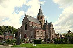
Church of Schelderode (2009) | |||
| |||
 Merelbeke Location in Belgium | |||
|
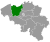
Location of Merelbeke in East Flanders  | |||
| Coordinates: 51°00′N 03°45′E / 51.000°N 3.750°ECoordinates: 51°00′N 03°45′E / 51.000°N 3.750°E | |||
| Country | Belgium | ||
| Community | Flemish Community | ||
| Region | Flemish Region | ||
| Province | East Flanders | ||
| Arrondissement | Ghent | ||
| Government | |||
| • Mayor | Filip Thienpont (CD&V) | ||
| • Governing party/ies | CD&V, VLD, SP.A | ||
| Area | |||
| • Total | 36.65 km2 (14.15 sq mi) | ||
| Population (1 January 2016)[1] | |||
| • Total | 24,279 | ||
| • Density | 660/km2 (1,700/sq mi) | ||
| Postal codes | 9820 | ||
| Area codes | 09 | ||
| Website | www.merelbeke.be | ||

Merelbeke (Dutch pronunciation: [ˈmeːrəlbeːkə]) is a municipality located in the Flemish province of East Flanders, in Belgium. The municipality comprises the villages of Bottelare, Lemberge, Melsen, Merelbeke proper, Munte and Schelderode. On January 1, 2006, Merelbeke had a total population of 22,353. The total area is 36.65 km² which gives a population density of 610 inhabitants per km².
References
- ↑ Population per municipality as of 1 January 2016 (XLS; 397 KB)
External links
 Media related to Merelbeke at Wikimedia Commons
- Official website (Dutch)
- Webpage at Internet Archive
 |
Ghent | Melle | | |
| De Pinte | |
|||
| ||||
| | ||||
| Gavere | |
Oosterzele |
This article is issued from Wikipedia - version of the 12/1/2016. The text is available under the Creative Commons Attribution/Share Alike but additional terms may apply for the media files.