Sotogahama, Aomori
| Sotogahama 外ヶ浜町 | |||
|---|---|---|---|
| Town | |||
|
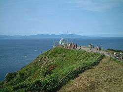
Cape Tappi, northernmost point of Tsugaru Peninsula | |||
| |||
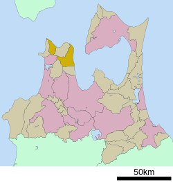 Location of Sotagahama in Aomori Prefecture | |||
 Sotogahama
| |||
| Coordinates: 41°02′37″N 140°37′58″E / 41.04361°N 140.63278°ECoordinates: 41°02′37″N 140°37′58″E / 41.04361°N 140.63278°E | |||
| Country | Japan | ||
| Region | Tōhoku | ||
| Prefecture | Aomori Prefecture | ||
| District | Higashitsugaru | ||
| Area | |||
| • Total | 230.29 km2 (88.92 sq mi) | ||
| Population (September 2015) | |||
| • Total | 6,012 | ||
| • Density | 26.1/km2 (68/sq mi) | ||
| Time zone | Japan Standard Time (UTC+9) | ||
| City symbols | |||
| - Tree | Pine | ||
| - Flower | Hydrangea | ||
| - Bird | Common gull | ||
| Phone number | 0174-31-1111 | ||
| Address |
Kanita, Takadoya 44-2, Sotogahama-machi, Higashitsugaru-gun, Aomori-ken 030-1393 | ||
| Website | Official website | ||


Sotogahama (外ヶ浜町 Sotogahama-machi) is a town located in Higashitsugaru District of northwestern Aomori Prefecture in the Tōhoku region of northern Japan. As of September 2015, the town had an estimated population of 6,012 and a population density of 26.1 persons per km2. Its total area was 230.29 square kilometres (88.92 sq mi).
Geography
Sotogahama occupies the eastern coastline of Tsugaru Peninsula, facing the Tsugaru Strait and the inlet to Mutsu Bay. The town has a cold maritime climate characterized by cool short summers and long cold winters with heavy snowfall. Much of the town is within the limits of the Tsugaru Quasi-National Park.
Neighbouring municipalities
History
The Tsugaru Peninsula has been inhabited since Japanese Paleolithic times, and some of the world's oldest pottery has been discovered at the Odai Yamamoto I site.[1][2][3] The area around Sotogahama was controlled by the Nambu clan of Morioka Domain during the Edo period. During the cadastral reform of 1889, Minmaya, Kanita and Tairadate villages were separated from Imabetsu. On March 28, 2005, these three municipalities merged to form the new town of Sotogahama. Minmaya is a geographically discontinuous enclave from the town's center in Kanita.
Economy
The economy of Sotogahama is heavily dependent on commercial fishing. Some of the locally caught seafood include sea urchin roe, sea pineapple, sea cucumber, scallops, abalone and squid.
Education
Sotogahama has three elementary schools and three middle schools.
Transportation
Railway
Highway
Noted people from Sotogahama
- Takahashi Chikuzan - noted tsugaru-jamisen artist
- Toru Hosokawa – professional baseball player
- Shinkishi Hatai - Biologist
References
- ↑ Habu Junko (2004). Ancient Jomon of Japan (Case Studies in Early Societies). Cambridge University Press. pp. 34–42. ISBN 978-0-521-77213-6.
- ↑ "大平山元I遺跡 -日本最古の土器出土-" [Ōdaiyamamoto Ichi Site - Excavation of Japan's Earliest Earthenware] (in Japanese). Aomori Prefecture. Retrieved 12 June 2012.
- ↑ Kaner, S. (2003). "Jomon pottery, Japan". Current World Archaeology. Current Publishing. Retrieved 12 June 2012.
External links
- (Japanese) Sotogahama official website
| Wikimedia Commons has media related to Sotogahama, Aomori. |
| Core city | ||
|---|---|---|
| Special city | ||
| Cities | ||
| Higashitsugaru District | ||
| Kamikita District | ||
| Kitatsugaru District | ||
| Minamitsugaru District | ||
| Nakatsugaru District | ||
| Nishitsugaru District | ||
| Sannohe District | ||
| Shimokita District | ||