Transport in the Netherlands
| Life in the Netherlands |
|---|
 |
|
Government |
The Netherlands is both a very densely populated and a highly developed country, in which transport is a key factor of the economy. Correspondingly it has a very dense and modern infrastructure, facilitating transport with road, rail, air and water networks. In its Global Competitiveness Report for 2014-2015, the World Economic Forum ranked the Dutch transport infrastructure fourth in the world.[1]
With a total road network of 139,000 km, including 3,530 km of expressways,[2] the Netherlands has one of the densest road networks in the world; much denser than Germany and France, but still not as dense as Belgium.[3] The Dutch also have a well developed railway network, that connects most major towns and cities, as well as a comprehensive dedicated cycling infrastructure, featuring some 35,000 km of track physically segregated from motorised traffic.[4]
The port of Rotterdam is the world's largest seaport outside East Asia, and by far the largest port of Europe.[5] It connects with its hinterland in Germany, Switzerland and France through rivers Rhine and Meuse. Two thirds of all inland water freight shipping within the E.U., and 40% of containers, pass through the Netherlands.[6]
Mobility in the Netherlands is considerable. On the roads it has grown continuously since the 1950s and now exceeds 200 billion km travelled per year,[7] three quarters of which are done by car.[8] Around half of all trips in the Netherlands are made by car, 25% by bicycle, 20% walking, and 5% by public transport.[8] Additionally, Dutch airports handled 58 million passengers in 2013.[9] Excluding air travel, the Dutch journey more than 30 km a day on average, which takes them just over an hour.[10]
In 2010, 1.65 billion tons of goods traffic was registered, half of which moved by sea and inland shipping, and 40% by road transport. The remainder was mostly by pipelines; rail transport only handles 2% of freight movements through the Netherlands.[11]
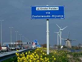
Road transport
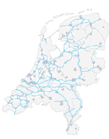
With 139,000 km of public roads,[2] the Netherlands has one of the most dense road networks in the world - much denser than Germany and France, but still not as dense as Belgium.[3][nb 1] In 2013, 5,191 km were national roads, 7,778 km were provincial roads, and 125,230 km were municipality and other roads.[13]
Dutch roads include 3,530 km of motorways and expressways,[2] and with a motorway density of 64 kilometres per 1,000 km², the country also has one of the densest motorway networks in the world.[12]
The Netherlands' main highway network (hoofdwegennet) - comparable to Britain's network of trunk roads - consists of most of its 5,200 km of national roads, supplemented with the most prominent provincial roads. Although only about 2,500 km are fully constructed to motorway standards,[14] much of the remainder are also expressways for fast motor vehicles only.
Mobility on Dutch roads has grown continuously since the 1950s and now exceeds 200 billion km travelled per year,[7] three quarters of which are done by car,[8] meaning that while Dutch roads are numerous, they are also used with one of the highest intensities of any road network.[12] Car ownership in the Netherlands is high but not exceptional, and slightly lower than in surrounding countries.[15] Goods vehicles account for 20% of total traffic.[12]
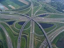
The busiest Dutch motorway is the A16 in Rotterdam, with a traffic volume of 232,000 vehicles per day.[16] The widest Dutch motorway is the A15/A16 just south of Rotterdam with 16 lanes in a 4+4+4+4 setup.
Cycling

Cycling is a ubiquitous mode of transport in the Netherlands. 27% of all trips are by bicycle[17] - the highest modal share of any country in the world. Moreover: 31% of the Dutch list the bike as their main mode of transport for daily activities.[18][19] Some 85% of the people own at least one bicycle. All in all the Dutch are estimated to have at least 18 million bikes,[20][21] which makes more than one per capita, and twice as many as the ca. 9 million motor vehicles on the road.[22] Almost as many passenger kilometres are covered by bicycle as by train.[8]
Cycling infrastructure is comprehensive, and public policy, urban planning & laws are bike-friendly. Most roads except for motorways support cyclists, and bikeways are clearly signposted, well maintained and well lit. Dedicated cycle tracks are common on busy roads - some 35,000 km of track has been physically segregated from motor traffic,[4] equal to a quarter of the country's entire road network. Busy junctions often give priority to cyclists, or they are equipped with cycle-specific traffic lights. There are large bicycle parking facilities, particularly in city centres and at train stations. In 2013, the European Cyclists' Federation ranked the Netherlands, together with Denmark as the most bike-friendly country in Europe.[23] Helmets are neither officially encouraged nor frequently worn.
Rail transport
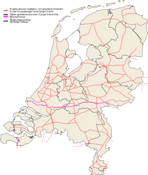

Most distance travelled on Dutch public transport is by rail.[8] Like many other European countries, the Netherlands has a dense railway network, totalling 6,830 kilometres of track,[24] or 3,013 route km, three quarters of which has been electrified.[25] The network is mostly focused on passenger transport[26] and connects virtually all major towns and cities, counting as many train stations as there are municipalities in the Netherlands. The national rail infrastructure is managed by public task company ProRail, and a number of different operators have concessions to run their trains.
Public passenger rail transport is operated mainly by Nederlandse Spoorwegen (NS) (Dutch Railways); minor parts by Arriva, Syntus, Connexxion, Breng, DB Regio, NMBS, Veolia[27] and DB Regionalbahn Westfalen. During week days almost all railway stations are serviced at least twice an hour in each direction. [nb 2], Large parts of the network are serviced by two to four trains per hour on average. Heavily used tracks are serviced up to 8 trains an hour. Per kilometre of track, the Dutch rail network is the busiest in the European Union,[26] handling over a million passengers a day.[24]
In recent years, the four largest railway stations in the Netherlands, the central stations of each of the largest cities: Amsterdam, Rotterdam, The Hague and Utrecht, have all entered into major reconstruction and expansion. The rebuild of Rotterdam Central was the first to complete, reopening in March 2014.
Public transport
For longer distances the main public transport in the Netherlands is the train. Long-distance buses are limited to a few missing railway connections. Regional / rural public transport, serving small(er) towns is by bus. Local / urban public transport is also generally by bus, but the three biggest cities (Amsterdam, Rotterdam and The Hague) all have extensive tram systems, that in each case also connect with adjacent cities in their respective urban agglomerations.[nb 3] Amsterdam and Rotterdam have several metro lines as well.

Additionally, Rotterdam, The Hague and suburbs in between are connected by a light rail system called RandstadRail, and one line of the Rotterdam metro system connects all the way to The Hague Central station. Utrecht has its own light rail system, called fast tram, connecting the city with adjacent Nieuwegein and IJsselstein. Arnhem is the only Dutch town that still operates a trolleybus system.
Due to the large amount of waterways in the Netherlands, not every road connection has been bridged, and there are still some ferries in operation. In the Rotterdam region, a water bus public transport service is operating as well.[28]
Public transport operators are both the public transport companies run by the big cities: GVB (Amsterdam), RET (Rotterdam) and HTM (The Hague), as well as private enterprise companies like Arriva, Connexxion, Qbuzz, Syntus and Veolia.
Air travel
Schiphol airport, just southwest of Amsterdam, is the main international airport in the Netherlands, and the fifth busiest airport in Europe in terms of passengers. Schiphol is the primary hub for Dutch flag carrier airline KLM and its regional affiliate KLM Cityhopper, as well as for other Dutch airlines Arkefly, Corendon Dutch Airlines, Martinair and Transavia.com. The airport also serves as a European hub for American carrier Delta Air Lines.
In other regions there are much smaller international airports, the most popular being Eindhoven Airport, Rotterdam The Hague Airport, Maastricht Aachen Airport and Groningen Airport. On the latter two, a considerable share of flights is seasonal in nature. For transport within the country, air travel is hardly used.
In 2013 Dutch airports handled 58 million passengers (41 million on European flights, and 17 million on intercontinental flights),[9] and 1.6 million metric tons of airfreight.[29]
Water transport


Ports and Harbours
The Netherlands has thirteen seaports,[30] three of which have international significance. Handling 440 million metric tons of cargo in 2013, the port of Rotterdam is the biggest port of Europe - as big as the next three biggest combined, and the eighth largest in the world.[5] The Amsterdam seaport is the second in the country, and the fifth largest in Europe.[5] Additionally, since 1998 the ports of Flushing and Terneuzen are working as one, under the name of Zeeland Seaports.[31] Handling 34 million metric tons of cargo in 2012, this is now the third biggest Dutch seaport. For comparison: the nearby port of London handled 44 million tons in that year.[5]
Through the rivers Rhine and Meuse, Rotterdam has excellent access to its hinterland upstream, reaching to Germany, France and Switzerland. The port's main activities are petrochemical industries and general cargo handling and transshipment. The harbour functions as an important transit point for bulk materials and between the European continent and overseas. From Rotterdam goods are transported by ship, river barge, train or road. In 2007, the Betuweroute, a new fast freight railway from Rotterdam to Germany, was completed.
Three Dutch ports are deepwater ports, that can handle fully laden Panamax ships: Rotterdam, Zeeland Seaports and the port of IJmuiden. Besides Rotterdam, Amsterdam and Zeeland, the ports of Moerdijk and Vlaardingen also support container liner shipping.[32] Other notable port cities are Dordrecht, Haarlem and Den Helder, as well as Groningen, which controls the seaports of Delfzijl and Eemshaven. Den Helder is home to the Netherlands' main naval base.
Merchant marine
- total: 563 ships (1,000 GRT or over) totaling 4,035,899 GRT/4,576,841 tonnes deadweight (DWT)
- ships by type: bulk 3, cargo 343, chemical tanker 41, combination bulk 2, container 56, liquified gas 20, livestock carrier 1, multi-functional large load carrier 8, passenger 8, petroleum tanker 25, refrigerated cargo 32, roll-on/roll-off 16, short-sea passenger 3, specialized tanker 5 (1999 est.)
note: many Dutch-owned ships are also operating under the registry of Netherlands Antilles (1998 est.)
Inland waters & shipping
6,237 km of rivers and canals are navigable for ships of 50 tons.[33][34] Some 3,740 km of this consists of canals.[30]
At least 4,326 km of waterways are usable by craft up to 400 metric ton capacity, and over 3,000 km are usable by ships up to 1,250 metric ton capacity.[34] Although another source states that all of 6,230 km is navigable for craft up to 400 tons, and over 4,000 km is usable by ships up to 1,500 metric ton capacity.[35]
The Dutch inland shipping fleet is the biggest in Europe.[6] Consisting of some 7,000 vessels, it takes a share of 35% of the national total annual freight transport, and as much as 80% of bulk transport.[36] Also two thirds of all inland water freight transports within the E.U., and 40% of inland container shipping, pass through the Netherlands.[6] All in all the Netherlands has so many waterways that virtually all major industrial areas and population centres can be reached by water via inland ports (200) and transhipment terminals (350).[35]
Pipelines
Crude oil 418 km; petroleum products 965 km; natural gas 10,230 km
Government
Transport in the Netherlands falls under the Ministry of Infrastructure and the Environment.
Economics
Although transport economics is much more than just the economy of the transport sector itself, the latter is much easier to quantify. In 2012 the Dutch goods transport and storage sectors by themselves accounted for almost 400,000 full-time jobs, employing some 500,000 people. Gross revenues totalled 77 billion euro, leading to results of 4.3 billion euro.[37]
See also
- Transport in Europe
- Transport in the Netherlands Antilles
- Rail transport in the Netherlands
- Road transport in the Netherlands
- Canals in the Netherlands
- Cycling in the Netherlands
- List of rivers of the Netherlands
External links
- Transportation Infrastructure - Netherlands Foreign Investment Agency by the Dutch government; distances are in miles
- World Port Source - Map of Netherlands ports
- Bureau Voorlichting Binnenvaart - Inland Navigation Promotion
Notes
- ↑ Japan has the same per country road density,[12] but the Netherlands' area includes 18.4% water, compared to 0.8% for Japan.
- ↑ On 14 December 2014 a revised railway timetable was implemented in the Netherlands, providing half-hour service to every station served by the NS in the country.
- ↑ There were many more town tram systems in the past, but most shut down before or just after WW II.
References
- ↑ Global Competitiveness Report 2014-2015 - World Economic Forum
- 1 2 3 "CIA World Factbook | Field listing: Roadways". www.cia.gov. U.S. Central Intelligence Agency. 2014. Retrieved 2015-08-17.
- 1 2 "Road density (km of road per 100 sq. km of land area) | Data | Table". http://data.worldbank.org. The World Bank Group. 2014. Retrieved 2014-07-07. External link in
|website=(help) - 1 2 "The Netherlands boast almost 35.000 km of cycling paths". fietsberaad.nl.
- 1 2 3 4 "Port Statistics 2013" (PDF) (Press release). Rotterdam Port Authority. 1 June 2014. p. 8. Retrieved 2014-06-28.
- 1 2 3 "Seaports - Netherlands Foreign Investment Agency". www.nfia.com. Netherlands Foreign Investment Agency. c. 2010. Retrieved 2014-07-15.
- 1 2 "SWOV Fact sheet | Mobility on Dutch roads" (PDF) (Press release). Leidschendam, the Netherlands: SWOV, Dutch Institute for Road Safety Research. July 2013. Retrieved 2014-07-07.
- 1 2 3 4 5 Waard, Jan van der; Jorritsma, Peter; Immers, Ben (October 2012). "New Drivers in Mobility: What Moves the Dutch in 2012 and Beyond?" (PDF). Delft, the Netherlands: OECD International Transport Forum. Retrieved 2014-07-07.
- 1 2 "CBS StatLine - Luchtvaart; maandcijfers Nederlandse luchthavens" [Dutch Statistics Bureau - Dutch airports monthly data]. http://statline.cbs.nl (in Dutch). CBS - Statistics Netherlands. 2013. Retrieved 2014-07-15. External link in
|website=(help) - ↑ "CBS StatLine - Mobiliteit in Nederland; mobiliteitskenmerken, regio's" [Dutch Statistics Bureau - Mobility Netherlands trips data]. http://statline.cbs.nl (in Dutch). CBS - Statistics Netherlands. 2013. Retrieved 2014-07-15. External link in
|website=(help) - ↑ "CBS StatLine - Goederenvervoer Nederland; vervoerwijzen en -stromen" [Dutch Statistics Bureau - Goods transport Netherlands data]. http://statline.cbs.nl (in Dutch). CBS - Statistics Netherlands. 2010. Retrieved 2014-07-15. External link in
|website=(help) - 1 2 3 4 "Road traffic, vehicles and networks | Environment at a Glance 2013: OECD Indicators" (PDF) (Press release). Paris, France: OECD Publishing. 2013. Retrieved 2014-07-10.
- ↑ "CBS StatLine - Lengte van wegen, wegkenmerken, regio" [CBS Statline - Length of roads, road types]. http://statline.cbs.nl (in Dutch). Statistics Netherlands. 2013. Retrieved 2014-07-12. External link in
|website=(help) - ↑ "Autosnelweg - WegenWiki" [Motorway - WegenWiki]. www.wegenwiki.nl (in Dutch). 2012. Retrieved 2014-07-17.
- ↑ List of countries by vehicles per capita
- ↑ "Pagina niet gevonden". rijkswaterstaat.nl.
- ↑ "Cycling in the Netherlands" (PDF) (Press release). The Netherlands: Ministry of Transport, Public Works and Water Management. Fietsberaad (Expertise Centre for Cycling Policy). 2009. Retrieved 2014-07-09.
- ↑ "Why is cycling so popular in the Netherlands?". BBC News. Archived from the original on 7 March 2014.
- ↑ Future of Transport report (PDF) (Report). European Commission. March 2011. p. 8. Archived from the original on March 7, 2014. Retrieved 11 July 2015.
- ↑ http://www.hollandtrade.com/media/features/feature-stories/?bstnum=4960
- ↑ "Cycling in the Netherlands - General information". iamexpat.nl.
- ↑ "CBS StatLine - Motor vehicles; general overview per period and technological features". cbs.nl.
- ↑ "European Cyclists' Federation – The first EU wide ECF Cycling Barometer launched". ecf.com.
- 1 2 Hofland, Dick (3 October 2014). "125 jaar Amsterdam Centraal" [Amsterdam Central station 125 years] (in Dutch). Sanoma Media Netherlands. Retrieved 4 October 2014.
- ↑ "CIA World Factbook | Field listing: Railways". www.cia.gov. U.S. Central Intelligence Agency. 2012. Retrieved 2014-07-07.
- 1 2 "Nederlandse spoor zeer intensief gebruikt" [Dutch railtracks intensely used]. www.treinreiziger.nl (in Dutch). Dutch Central Bureau of Statistics (CBS). 1 March 2009. Retrieved 2014-07-09.
- ↑ Veolia Transportation, Veolia Transport, retrieved March 25, 2015. (Dutch)
- ↑ "Waterbus". Rotterdam Tourism & Convention Board. Retrieved 28 January 2015.
- ↑ "CBS StatLine - Luchtvaart; maandcijfers Nederlandse luchthavens" [Dutch Statistics Bureau - Dutch airports monthly data]. http://statline.cbs.nl (in Dutch). CBS - Statistics Netherlands. 2013. Retrieved 2014-07-15. External link in
|website=(help) - 1 2 "Transportation Infrastructure - Netherlands Foreign Investment Agency". www.nfia.com. Netherlands Foreign Investment Agency. c. 2010. Retrieved 2014-07-15.
- ↑ nl:Haven van Zeeland
- ↑ Mark E. Waters. "World Port Source - Ports with Liner Service in Netherlands". www.worldportsource.com. World Port Source. Retrieved 2014-07-16.
- ↑ "CIA World Factbook | Field listing: Waterways". www.cia.gov. U.S. Central Intelligence Agency. 2012. Retrieved 2014-07-07.
- 1 2 "CBS StatLine - Lengte van vaarwegen; vaarwegkenmerken, provincie" [Dutch Statistics Bureau - Waterways and characteristics]. http://statline.cbs.nl (in Dutch). CBS - Statistics Netherlands. 2013. Retrieved 2014-07-15. External link in
|website=(help) - 1 2 The power of inland navigation (PDF). Rotterdam, the Netherlands: Dutch Inland Navigation Information Agency (BVB). 2013. p. 47. Retrieved 2014-07-11.
- ↑ "Binnenvaart in Cijfers". http://www.bureauvoorlichtingbinnenvaart.nl. Bureau Voorlichting Binnenvaart. 2013. Retrieved 2014-07-11. External link in
|website=(help) - ↑ "CBS StatLine - Transportbedrijven; arbeids- en financiële gegevens, per branche, SBI 2008" [Dutch Statistics Bureau - Transport sectors; economic data]. http://statline.cbs.nl (in Dutch). CBS - Statistics Netherlands. 2012. Retrieved 2014-07-15. External link in
|website=(help)