Tsumagoi, Gunma
| Tsumagoi 嬬恋村 | |||
|---|---|---|---|
| Village | |||
|
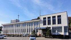
Tsumagoi village office | |||
| |||
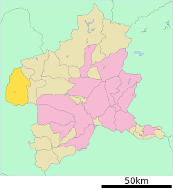 Location of Tsumagoi in Gunma Prefecture | |||
 Tsumagoi
| |||
| Coordinates: 36°31′0.6″N 138°31′48.5″E / 36.516833°N 138.530139°ECoordinates: 36°31′0.6″N 138°31′48.5″E / 36.516833°N 138.530139°E | |||
| Country | Japan | ||
| Region | Kantō | ||
| Prefecture | Gunma Prefecture | ||
| District | Agatsuma | ||
| Area | |||
| • Total | 337.58 km2 (130.34 sq mi) | ||
| Population (February 2015) | |||
| • Total | 9,691 | ||
| • Density | 28.7/km2 (74/sq mi) | ||
| Time zone | Japan Standard Time (UTC+9) | ||
| - Tree | Silver birch | ||
| - Flower | Japanese Gentian | ||
| - Fish | Oncorhynchus masou | ||
| Phone number | 0279-96-0511 | ||
| Address | 110 Ōaza Ōmae, Tsumagoi-mura, Agatsuma-gun, Gunma-ken 377-1692 | ||
| Website | Official website | ||


Tsumagoi (嬬恋村 Tsumagoi-mura) is a village located in Agatsuma District of west-central Gunma Prefecture in the northern Kantō region of Japan. As of February 2015, the village had an estimated population of 9,691 and a population density of 28.7 persons per km². Its total area was 337.51 km².
Geography
Tsumagoi is situated on the northwestern corner of Gunma Prefecture, touching Nagano Prefecture to the north, south, and west. Because of its elevated location and the ash deposits of Mount Asama, Tsumagoi is fit and well known for growing cabbages. It has a cool climate, with an average yearly temperature of 7℃.[1][2]
- Mountains: Mount Asama (2568m), Mount Motoshirane (2171m), Mount Kusatsu-Shirane (2160m), Mount Azumaya (2354m)
- Rivers: Agatsuma River
- Lakes: Lake Baragi, Lake Tashiro
Surrounding municipalities
Climate
| Climate data for Tsumagoi | |||||||||||||
|---|---|---|---|---|---|---|---|---|---|---|---|---|---|
| Month | Jan | Feb | Mar | Apr | May | Jun | Jul | Aug | Sep | Oct | Nov | Dec | Year |
| Daily mean °C (°F) | −4.6 (23.7) |
−4.3 (24.3) |
−0.9 (30.4) |
5.7 (42.3) |
10.9 (51.6) |
14.7 (58.5) |
18.6 (65.5) |
19.5 (67.1) |
15.3 (59.5) |
9.1 (48.4) |
3.6 (38.5) |
−1.5 (29.3) |
7.2 (45) |
| Average precipitation mm (inches) | 49.0 (1.929) |
60.9 (2.398) |
102.5 (4.035) |
106.9 (4.209) |
138.7 (5.461) |
180.8 (7.118) |
208.7 (8.217) |
175.9 (6.925) |
232.3 (9.146) |
133.8 (5.268) |
74.5 (2.933) |
42.6 (1.677) |
1,506.6 (59.315) |
| Source: 気象庁[3] | |||||||||||||
History
Numerous Jomon period remains have been found in Tsumagoi, although later Yayoi period artifacts are almost non-existent, as the area is not suitable for rice cultivation. During the Edo period, the area around Tsumagoi was part of the hatamoto-administered territory within Kōzuke Province. With the creation of the municipalities system after the Meiji Restoration on April 1, 1889, the village of Tsumagoi was created within Agatsuma District of Gunma Prefecture.
Economy
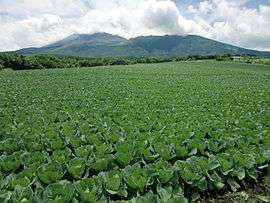
The economy of Tsumagoi is primarily agricultural, with cabbages forming the most noted local crop. Seasonal tourism primarily in connection with its onsen hot spring resorts and ski resorts are also major contributors to the local economy.
Education
Senior high schools
- Tsumagoi High School
Junior high schools
- Nishi Junior High School
- Higashi Junior High School
Elementary schools
- Higashi Elementary School
- Tashiro Elementary School
- Nishi Elementary School
- Hoshimata Elementary School
- Kanbara Elementary School
Transportation
Train
Highway
Local attractions
The main draw of tourists to Tsumagoi are the onsen (natural hot spring) resorts, some of which are also associated with ski resorts. There are two major hot spring resort areas within the town.
- Manza Onsen and ski resort
- Kazawa Onsen and ski resort
- Tsumagoi Onsen
- Handeki Onsen
Noted people from Tsumagoi
- Akira Kuroiwa – Olympic gold medalist speed skater
- Toshiyuki Kuroiwa – Okympic silver medalist speed skater
- Masato Kobayashi – professional baseball player
References
- ↑ 沿革
- ↑ 考える社会科地図 Kangaeru Shakaika Chizu. 四谷大塚出版 Yotsuya-Ōtsuka Shuppan. 2005. p. 57.
- ↑ 気象庁(田代の平年値) "気象庁" Check
|url=value (help). Retrieved 2014-12-18.
External links
| Wikimedia Commons has media related to Tsumagoi, Gunma. |
- Official website (Japanese)
| Core cities | ||
|---|---|---|
| Special cities | ||
| Cities | ||
| Agatsuma District | ||
| Kanra District | ||
| Kitagunma District | ||
| Ōra District | ||
| Sawa District | ||
| Tano District | ||
| Tone District | ||