U.S. Route 33
| |
|---|---|
 | |
| Route information | |
| Length: | 709 mi[1] (1,141 km) |
| Existed: | 1937[1] – present |
| Major junctions | |
| East end: |
|
|
| |
| North end: |
|
| Location | |
| States: | Virginia, West Virginia, Ohio, Indiana |
| Highway system | |

U.S. Route 33 is a United States Numbered Highway that runs northwest–southeast for 709 miles (1,141 km) from northern Indiana to Richmond, Virginia, passing through Ohio and West Virginia en route. Although most odd-numbered U.S. routes are north–south, US 33 is labeled east–west throughout its route except in Indiana where it is labeled north–south.
As of 2016, the highway's northern terminus is at U.S. Highway 20 in southeastern Elkhart, Indiana. Its eastern terminus is in Richmond, Virginia. Prior to 1998, the route extended northward through South Bend, Indiana, to Niles, Michigan. In Virginia, "Route 33" continues east as State Route 33 to Stingray Point, on the Chesapeake Bay near Deltaville, Virginia.
Route description
Indiana
Beginning with its terminus at US 20 on the southeast side of Elkhart, US 33 is a winding road that cuts diagonally from northwest to southeast through Northeast Indiana and serves as Main Street or a portion of Main Street in several cities and towns, including Elkhart, Dunlap, Goshen and Churubusco.
The road is the main overland link between the Fort Wayne metropolitan area and South Bend metropolitan statistical areas.
From Elkhart, U.S. 33 continues southeast passing through the suburbs of Dunlap and Midway before crossing State Road 15 and State Road 4, then continues southeast toward Benton as Lincolnway East.
Southeast of Benton, U.S. 33 intersects State Road 13 before joining with US 6 to become an east–west rural highway running for a few miles between just north of Lake Wawasee near Syracuse to Ligonier at the intersection of State Road 5, where US 33 splits from US 6 and turns south, joining SR 5 as a north–south road for a few miles before splitting off to the southeast toward Kimmell as it enters Noble County.
US 33 continues southeast through Noble County until it reaches Wolf Lake, where it serves as the northern terminus of State Road 109 before continuing until its intersection with State Road 9 at Merriam just north of the Whitley County line. In Whitley County, the road curves eastward to bypass Blue Lake before intersecting with State Road 205 in Churubusco near the county line with Allen County as it heads toward Fort Wayne.
On the west side of Fort Wayne, US 33 joins US 30 near Interstate 69, then follows the interstate south, intersecting with SR 14 and US 24 before turning east to follow the Interstate 469 bypass around the southwest side of Fort Wayne. At the intersection with SR 1 south of the Fort Wayne International Airport, I-469/US 33 turns to the northeast until it intersects US 27 at the Fort Wayne suburb of Hessen Cassel, where US 33 splits off to the southeast to follow US 27 as a combined highway toward Decatur.
At Decatur, US 33/US 27 becomes a north–south road before it intersects with US 224 and continues as such until US 33 splits off from US 27 south of Decatur and heads east toward the Ohio state line, intersecting SR 101 at Pleasant Mills along the way.
Ohio
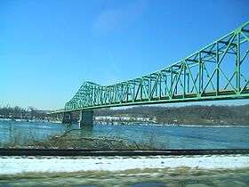
In Ohio, the highway runs at a generally southeast-northwest angle from the west-central to the southeastern part of the state, passing through mostly rural territory except for a significant portion running through downtown Columbus. Most of the route in the state, particularly east of Columbus, is expressway. The highway crosses over the Ravenswood Bridge into West Virginia.
West Virginia


US 33 extends 248 miles (399 km) in West Virginia, from the Ohio River at Ravenswood to the Virginia state line atop Shenandoah Mountain west of Harrisonburg, Virginia.
_near_Nilhor_Lane_in_Brandywine%2C_Pendleton_County%2C_West_Virginia.jpg)
Shortly after entering West Virginia and crossing the Ohio River, US 33 turns south, joining Interstate 77 to Ripley. The route then turns east from I-77, joining US 119 at Spencer, then passing through extremely rural areas of Roane, Calhoun, Gilmer, and Lewis counties.
US 33 Intersects Interstate 79 at Weston, West Virginia. From Interstate 79 east, US 33 is a four-lane highway, part of Corridor H of the Appalachian Development Highway System. The four-lane segment continues on through rural areas of Upshur, and Randolph counties, to just a couple miles past Elkins.
At Harding, US 250 joins US 33 for several miles after Elkins, where US 33 joins SR 55 and returns to a two-lane road, except for a seven-mile (11 km) section of four-lane across Kelly Mountain between Canfield and Bowden. Passing through the Monongahela National Forest, US 33 crosses the Eastern Continental Divide between Harman and Onego at about 3,240 feet (990 m) elevation, entering Pendleton County, then descends the Allegheny Front along Seneca Creek, skirting the north end of Spruce Mountain, at 4,861 feet (1,482 m) the highest point of the Allegheny Mountains.
US 33 then joins SR 28 at Seneca Rocks, West Virginia, and continues south in the Potomac River headwaters through scenic forest and farmland landscapes. Turning eastward from SR 28 at Judy Gap, US 33 crosses North Fork Mountain at about 3,600 feet (1,100 m), with a turnout on the western slope offering a scenic view of the Germany Valley below and the more distant Allegheny Front from Spruce Knob to Dolly Sods. US 220 joins US 33 for about half a mile in Franklin. After Franklin, US 33 continues eastward through rural areas, then climbs steeply to cross Shenandoah Mountain at Dry River Gap at about 3,450 feet (1,050 m) into Rockingham County, Virginia.
Virginia
U.S. Route 33 extends 139 miles (224 km) in Virginia from the West Virginia state line west of Harrisonburg across the Shenandoah Valley, Blue Ridge Mountains, and Atlantic Piedmont to Richmond.
From Richmond, "Route 33" continues east as Virginia State Route 33 across the Atlantic coastal plain through the Tidewater region of the Middle Peninsula to reach the Chesapeake Bay at Stingray Point just east of Deltaville.
History
US 33 formerly ended in St. Joseph, Michigan, at the junction of the old U.S. Highway 12, was extended to a junction with Interstate 196 near Lake Michigan Beach, Michigan, north of St. Joseph, but later truncated south of Niles, Michigan (junction U.S. Highway 12), then in April 1998 at Elkhart, Indiana.[2] Before its second truncation, it passed through Mishawaka and South Bend, Indiana.[3][4] Former segments of US 33 are now known as M-63, M-51, and State Road 933. Between South Bend and Fort Wayne, US 33 was part of the Lincoln Highway.
Various segments of US 33 have been improved to limited-access freeways. These include Ohio segments from St. Marys to Wapakoneta; Huntsville (near Bellefontaine) to Dublin (a northwestern suburb of Columbus); and bypasses around Lancaster, Nelsonville,[5][6] and Pomeroy.
In West Virginia, US 33 from Interstate 79 near Weston east nearly to Elkins is four-lane, built as part of Corridor H of the Appalachian Development Highway System. The route's steep grade up Shenandoah Mountain is easternmost West Virginia has been widened, with some sharp curves improved.
Proposed improvements
The State of Ohio plans to eventually make US 33 a controlled-access freeway from the Interstate 75 interchange near Wapakoneta to Athens, Ohio, except for the section inside I-270, the Columbus Beltway.
Major intersections
- Virginia
-
 US 250 in Richmond. The highways travel concurrently through the city.
 -
 I‑64 in Dumbarton
 -
 I‑295 northwest of Glen Allen
 -
 US 522 in Cuckoo. The highways travel concurrently to north-northwest of Cuckoo.
 -
 US 15 south of Gordonsville. The highways travel concurrently to Gordonsville.
 -
 US 29 in Ruckersville
 -
 US 340 in Elkton
 -
 I‑81 in Harrisonburg
 -
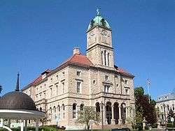
 US 11 in Harrisonburg. The highways travel concurrently around the Rockingham County Courthouse.
 - West Virginia
-
 US 220 in Franklin. The highways travel concurrrently to north of Franklin.
 -
 US 219 / US 250 in Elkins. US 33/US 219 travels concurrently to north of Elkins. US 33/US 250 travel concurrently to north of Norton.
 -
 US 119 in Buckhannon. The highways travel concurrently to Spencer.
 -
 I‑79 southeast of Weston
 -
 US 19 in Weston. The highways travel concurrently through the city.
 -
 I‑77 in Ripley. The highways travel concurrently to Silverton.
 - Ohio
-
 US 50 in Athens. The highways travel concurrently to east of Athens.
 -
 US 22 southwest of Lancaster
 -
 I‑270 in Columbus
 -
 I‑70 in Columbus
 -
 US 23 in Columbus. The highways travel concurrently through the city.
 -
 US 62 in Columbus. The highways travel concurrently through the city.
 -
 US 40 / US 62 in Columbus
 -
 I‑670 in Columbus
 - I‑270 in Dublin
-
 US 42 northeast of New California
 -
 US 36 in Marysville. The highways travel concurrently to west of Marysville.
 -
 US 68 in Bellefontaine
 -
 I‑75 in Wapakoneta
 -
 US 127 southeast of Rockford
 - Indiana
-
 US 27 in Decatur. The highways travel concurrently to south-southeast of Fort Wayne.
 -
 US 224 in Decatur. The highways travel concurrently through the city.
 -

 I‑469 / US 24 / US 27 south-southeast of Fort Wayne. I-469/US 33 travels concurrently to east of Roanoke. US 24/US 33 travels concurrently around the southwestern side of Fort Wayne.
 -
 I‑69 east of Roanoke. The highways travel concurrently to Fort Wayne.
 -
 I‑69 / US 30 in Fort Wayne. US 30/US 33 travels concurrently through the city.
 -
 US 6 in Ligonier. The highways travel concurrently to northeast of Syracuse.
 -
 US 20 in Elkhart
See also
 U.S. Roads portal
References
- 1 2 Droz, Robert V. U.S. Highways : From US 1 to (US 830). URL accessed 02:55, 4 July 2006 (UTC).
- ↑ "Portion of U.S. 33 is now Indiana 933". South Bend Tribune. April 18, 1998. Retrieved December 29, 2008.
- ↑ Christopher J. Bessert (January 1, 2008). "Historic US-33". Michigan Highways. Retrieved March 14, 2008.
- ↑ Charles Sarjeant. "US 33". Indiana Highway Ends. Retrieved March 14, 2008.
- ↑ Lane, Mary Beth (October 2, 2013). "Rt. 33 [sic] Motorists Save Time as Nelsonville Bypass Opens". The Columbus Dispatch. Retrieved October 3, 2013.
- ↑ "US 33 Nelsonville Bypass". The Ohio Department of Transportation. Retrieved April 23, 2013.
External links
Routes in italics are no longer a part of the system. Highlighted routes are considered main routes of the system. |