U.S. Route 224
| ||||||||||
|---|---|---|---|---|---|---|---|---|---|---|
 | ||||||||||
| Route information | ||||||||||
| Auxiliary route of US 24 | ||||||||||
| Length: | 288.21 mi[1][2][3] (463.83 km) | |||||||||
| Major junctions | ||||||||||
| West end: |
| |||||||||
|
| ||||||||||
| East end: |
| |||||||||
| Location | ||||||||||
| States: | Indiana, Ohio, Pennsylvania | |||||||||
| Counties: |
IN: Huntington, Wells, Adams OH: Van Wert, Putnam, Hancock, Seneca, Huron, Ashland, Medina, Summit, Portage, Mahoning PA: Lawrence | |||||||||
| Highway system | ||||||||||
| ||||||||||

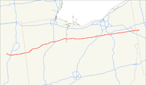
U.S. Route 224 (US 224) is a spur of U.S. Route 24. It currently runs for 289 miles (465 km) from Huntington, Indiana at US 24 to New Castle, Pennsylvania at US 422 Business (US 422 Bus.) and Pennsylvania Route 18 (PA 18) . It passes through the states of Indiana, Ohio and Pennsylvania. It goes through the cities of Canfield, Ohio, Akron, Ohio, and Findlay, Ohio. In Northeast Ohio, US 224 is located a short distance north of the Western Reserve's southern boundary.
Route description
Indiana
From the western terminus US 224 heads southeast concurrent with State Road 5 (SR 5). US 224 and SR 5 heads through downtown Huntington as one-way streets, with eastbound on Cherry Street and State Street and westbound on Warren Street. From downtown US 224 and SR 5 head southeast then outside of downtown SR 5 heads due south and US 224 heads east. US 224 passes through Markle where US 224 has an interchange with Interstate 69 (I-69) and intersections with both State Road 116 (SR 116) and State Road 3 (SR 3). US 224 heads east towards Decatur passing through intersections with State Road 301 (SR 301) and State Road 1 (SR 1). In Decatur US 224 has a short concurrency with U.S. Route 27 (US 27) and U.S. Route 33 (US 33). US 224 heads east from Decatur towards Ohio passing through a short concurrency with State Road 101 (SR 101).[4]
The only section of U.S. Route 224 in Indiana that is included in the National Highway System is the part concurrent with US 27 and US 33.[5] Traffic reports from the Indiana Department of Transportation in 2010 showed that the lowest traffic levels were the 2,420 vehicles and 670 commercial vehicles using the highway daily near the Ohio state line; the highest traffic levels were the 21,680 vehicles and 1,690 commercial vehicles traveling along the section of US 224 that is concurrent with US 27 and US 33.[6]
Ohio
West of its concurrency with US 42 near Lodi, Ohio, US 224 is a rural arterial highway, mostly two lanes, across western Ohio. It runs roughly parallel to the former Baltimore & Ohio Railroad from its westerly US 42 junction to Tiffin, Ohio, a city around which it sweeps to the south with intersections at various state highways that radiate out from downtown. US 224 passes through a commercial strip on the south side of Willard, Ohio, and goes through downtown Findlay and Ottawa, Ohio, but it otherwise specializes in small towns along its course across northwest Ohio. It crosses US 250 east of Greenwich, Ohio; Ohio Route 4 (a major north-south route) at Attica, Ohio; US 23 south of Fostoria, Ohio, and I-75 in Findlay, and has brief concurrences with US 127 and US 30 near Van Wert, Ohio. It crosses the Ashland Railway just east of Willard, the Norfolk Southern railroad at Attica, CSX Transportation near US 23, in Findlay, and in Ottawa, and the Chicago, Fort Wayne & Eastern west of Van Wert.
East of Lodi, OH, US 224 meets the western terminus of Interstate 76, with which it forms a concurrency. Less than a mile later, both routes intersect with Interstate 71. US 224 continues along with Interstate 76 to Akron. Here, interstate 76 exits and heads north. Continuing on US 224, the route runs concurrent with Interstate 277, a short auxiliary highway running though southern Akron. Interstate 277 quickly ends, leaving US 224 to continue into a heavily wooded area. The highway then intersects with Ohio State Routes 43, 44, 169, 225, 14, 45, and 46. Shortly after crossing over Ohio State Route 11, US 224 enters the township of Boardman, OH. This stretch of US 224, through Canfield, Boardman, and Poland, OH is known for its chronic congestion. As US 224 leaves the village of Poland, OH, it curves towards the southeast and continues through rural terrain as it heads towards Pennsylvania.
Pennsylvania
US 224 crosses into Mahoning Township in Lawrence County, Pennsylvania and becomes West State Street, a two-lane undivided road. The road heads through wooded areas with some homes and commercial establishments, heading to the east-southeast. The route curves to the northeast in Peanut and passes over a Norfolk Southern railroad line, coming to an intersection with PA 551. Here, PA 551 turns northeast to form a concurrency with US 224. The road heads through wooded areas and crosses the Mahoning River and two CSX railroad lines. PA 551 splits from US 224 by heading north on North Edinburg Road, with US 224 continuing into wooded areas with some farm fields. The road turns to the southeast and enters Union Township. The route continues through wooded areas with some farmland and homes, passing to the south of New Castle Municipal Airport and heading through the community of Parkstown. US 224 heads into businesses areas, gaining a second lane westbound before widening into a six-lane divided highway as it comes to an interchange with I-376/US 422.[7][8]
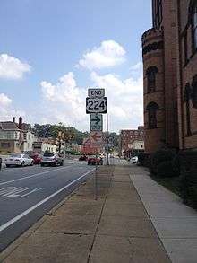
Past this interchange, the road becomes a three-lane road with a center left-turn lane and passes through a mix of residences and businesses, running through the community of Oakwood. The route heads into New Castle and passes through wooded areas of development, gaining a second westbound lane and coming to an intersection with US 422 Business. At this point, US 422 Business turns east to join US 224 on four-lane divided West Falls Street, passing more development and crossing over a New Castle Industrial Railroad line and the Shenango River. The road heads to the east and continues through commercial areas. US 224 ends at an intersection with PA 18, at which point US 422 Business turns south to join that route.[7][8]
History
When US 224 was commissioned in Indiana in 1934, it replace State Road 16 (SR 16), from Huntington to the Ohio state line.
Although U.S. 224 is only in Pennsylvania for 10 miles, the eastern terminus has changed several times since being issued in 1933, ending at various points in New Castle, Pennsylvania or in adjacent Union Township west of the city.[9] The eastern terminus has been moved five times (1936, 1947, 1974, 1977, 2008), the most notable of which was in the 1970s when the New Castle Bypass opened in 1974 and saw an extension of U.S. 224 through the city itself and into Shenango Township at the eastern terminus of the bypass, essentially taking over U.S. 422's old alignment after 422 moved to the bypass.
The route was truncated back at the current interchange with 422 and Interstate 376 in 1977 while the old alignment through New Castle was replaced by Business 422. This would be the case until March 20, 2008, when 224 was officially extended two miles (3 km) to PA 18 inside the New Castle city limits with the placement of new signs. PennDOT had gotten approval from the AASHTO for the extension in September 2007.[10]
The extension of U.S. 224 marked the second extension of a major highway into downtown New Castle in a little more than a year, as Pennsylvania Route 65 was extended a mile from its previous terminus with Business 422 to the PA 108/PA 168 concurrency in February 2007.
Major intersections
| State | County | Location | mi[1][2][3] | km | Exit | Destinations | Notes |
|---|---|---|---|---|---|---|---|
| Indiana | Huntington | Huntington | 0.00 | 0.00 | Western terminus of US 224; western end of SR 5 concurrency | ||
| 3.25 | 5.23 | Eastern end of SR 5 concurrency | |||||
| Markle | 10.00 | 16.09 | Exit 82 on I-69 | ||||
| 10.23 | 16.46 | Western terminus of SR 116 | |||||
| 11.00 | 17.70 | Northern terminus of SR 3 | |||||
| Wells | Kingsland | 20.03 | 32.24 | ||||
| Lancaster–Jefferson township line | 23.97 | 38.58 | Northern terminus of SR 301 | ||||
| Adams | Decatur | 32.05 | 51.58 | Northern end of US 27/US 33 concurrency | |||
| 32.27 | 51.93 | Southern end of US 27/US 33 concurrency | |||||
| Union Township | 36.51 | 58.76 | Western end of SR 101 concurrency | ||||
| 37.52 | 60.38 | Eastern end of SR 101 concurrency | |||||
| 39.63 0.00 | 63.78 0.00 | Indiana–Ohio state line | |||||
| Ohio | Van Wert | Harrison Township | 1.47 | 2.37 | Western end of SR 49 concurrency | ||
| 5.10 | 8.21 | Eastern end of SR concurrency | |||||
| Pleasant Township | 10.70– 10.98 | 17.22– 17.67 | Western end of US 30 concurrency | ||||
| Van Wert | 14.50 | 23.34 | Eastern end of US 30 concurrency; southern end of US 127 concurrency | ||||
| 15.85 | 25.51 | Northern end of US 127 concurrency | |||||
| | 21.68 | 34.89 | Southern terminus of SR 637 | ||||
| Putnam | Monterey Township | 27.73 | 44.63 | Western end of SR 66 concurrency | |||
| Ottoville | 28.72 | 46.22 | Eastern end of SR 66 concurrency; western terminus of SR 189 | ||||
| 28.83 | 46.40 | Western terminus of SR 189 | |||||
| Jackson Township | 31.67 | 50.97 | |||||
| 32.92 | 52.98 | Northern terminus of SR 190 | |||||
| Kalida | 37.16 | 59.80 | Eastern terminus of SR 114 | ||||
| 37.29 | 60.01 | Western end of SR 115 concurrency | |||||
| 37.49 | 60.33 | Eastern end of SR 115 concurrency | |||||
| Glandorf | 45.08 | 72.55 | Eastern terminus of SR 694 | ||||
| Ottawa | 46.29 | 74.50 | Western end of SR 15 concurrency; southern terminus of SR 109 | ||||
| Hancock | Blanchard Township | 60.58 | 97.49 | ||||
| 62.60 | 100.74 | Southern terminus of SR 186 | |||||
| Findlay | 67.09 | 107.97 | Eastern end of SR 15 concurrency | ||||
| 69.01 | 111.06 | Western end of SR 12 concurrency; northern terminus of SR 37 | |||||
| 70.19 | 112.96 | Eastern end of SR 12 concurrency | |||||
| Seneca | Loudon Township | 82.41 | 132.63 | ||||
| 85.00 | 136.79 | ||||||
| Tiffin | 91.99 | 148.04 | |||||
| 93.33 | 150.20 | ||||||
| 94.87 | 152.68 | ||||||
| 96.10 | 154.66 | ||||||
| Scipio Township | 101.19 | 162.85 | |||||
| 103.30 | 166.25 | ||||||
| Attica | 110.23 | 177.40 | |||||
| Huron | Willard | 118.63 | 190.92 | ||||
| 119.51 | 192.33 | Southern terminus of SR 99 | |||||
| 121.84 | 196.08 | ||||||
| Greenwich Township | 132.09 | 212.58 | |||||
| Ashland | Ruggles Township | 135.63 | 218.28 | ||||
| 136.94 | 220.38 | ||||||
| Nova | 141.53 | 227.77 | |||||
| Sullivan | 145.86 | 234.74 | |||||
| Medina | Homerville | 150.87 | 242.80 | ||||
| Lodi | 154.77 | 249.08 | Southern end of US 42 concurrency; western terminus of SR 421 | ||||
| 157.41 | 253.33 | ||||||
| 158.89 | 255.71 | Northern end of US 42 concurrency; eastern end of SR 421 | |||||
| Westfield Center | 164.26 | 264.35 | 1 | Western end of I–76 concurrency; western terminus of I–76. I-71 exits 209A-B. | |||
| 166.12 | 267.34 | 2 | |||||
| Wadsworth | 174.52 | 280.86 | 7 | ||||
| 173.56 | 279.32 | 9 | |||||
| 175.56 | 282.54 | 11 | |||||
| Summit | Norton | 177.12 | 285.05 | 13 | |||
| 178.45 | 287.19 | 14 | Cleveland Massillon Road | ||||
| Akron | 179.99 | 289.67 | 16 | Barber Road | |||
| 181.33 | 291.82 | 17A | State Street | Eastbound exit and westbound entrance only | |||
| 181.63 | 292.31 | 17 | |||||
| 182.14 | 293.13 | 18 1 | Eastern end of I–76 concurrency; western terminus of I–277; western end of I–277 concurrency | ||||
| 183.29– 183.48 | 294.98– 295.28 | 2 | |||||
| 184.61 | 297.10 | 3 | Main Street | ||||
| 185.88 | 299.14 | 4 | Eastern end of I–277 concurrency; and signed as exits 4A (south) & 4B (north); eastern terminus of I–277. I-77 exits 122A-B. | ||||
| 186.88 | 300.75 | Kelly Avenue | |||||
| 187.35 | 301.51 | Akron Fulton International Airport | Eastbound exit and entrance only | ||||
| 188.03 | 302.60 | ||||||
| Springfield Township | 190.08 | 305.90 | Southern terminus of SR 91 | ||||
| Summit–Portage county line | Springfield–Suffield township line | 191.90 | 308.83 | Southern terminus of SR 532 | |||
| Portage | Suffield Township | 194.32 | 312.73 | ||||
| Randolph Township | 199.61 | 321.24 | |||||
| Atwater | 204.89 | 329.74 | Northern end of SR 183 concurrency | ||||
| 205.42 | 330.59 | Eastern end of SR 193 concurrency | |||||
| | 208.00 | 334.74 | Western end of SR 225 concurrency | ||||
| Deerfield Township | 210.49 | 338.75 | Eastern end of SR 225 concurrency | ||||
| Mahoning | Berlin Center | 215.98 | 347.59 | ||||
| Ellsworth | 220.70 | 355.18 | |||||
| Canfield | 224.72 | 361.65 | Northern terminus of SR 446 | ||||
| 225.76 | 363.33 | ||||||
| 226.88 | 365.13 | ||||||
| Boardman | 228.38 | 367.54 | Southern terminus of SR 625 | ||||
| 230.91 | 371.61 | ||||||
| 232.77 | 374.61 | ||||||
| Poland | 233.43 | 375.67 | |||||
| 233.54 | 375.85 | ||||||
| 238.43 0.00 | 383.72 0.00 | Ohio–Pennsylvania state line | |||||
| Pennsylvania | Lawrence | Mahoning Township | 4.33 | 6.97 | West end of PA 551 concurrency | ||
| 4.95 | 7.97 | East end of PA 551 concurrency | |||||
| Union Township | 7.86 | 12.65 | I-376/US 422 exit 13 | ||||
| New Castle | 8.91 | 14.34 | West end of US 422 Bus. concurrency | ||||
| 10.15 | 16.33 | East end of US 422 Bus. concurrency | |||||
1.000 mi = 1.609 km; 1.000 km = 0.621 mi
| |||||||
See also
 Indiana portal
 Ohio portal
 Pennsylvania portal
 U.S. Roads portal
References
- 1 2 Indiana Department of Transportation (2004). Reference Post Book (PDF). Indianapolis: Indiana Department of Transportation. U-224. Archived (PDF) from the original on October 6, 2014. Retrieved April 25, 2011.
- 1 2 "Straight Line Diagrams". Retrieved 2012-11-19.
- 1 2 "Penndot - Pennsylvania Stateroads". Retrieved 2012-11-20.
- ↑ Google (2011-04-25). "overview map of US 224 in Indiana" (Map). Google Maps. Google. Retrieved 2011-04-25.
- ↑ Federal Highway Administration (December 2003). National Highway System: Indiana (PDF) (Map). Scale not given. Washington, DC: Federal Highway Administration. Retrieved October 16, 2012.
- ↑ Indiana Department of Transportation (2010). "Indiana Traffic Counts". Indianapolis: Indiana Department of Transportation. Retrieved August 14, 2012.
- 1 2 Google (December 30, 2011). "overview of U.S. Route 224 in Pennsylvania" (Map). Google Maps. Google. Retrieved December 30, 2011.
- 1 2 Lawrence County, Pennsylvania Highway Map (PDF) (Map). PennDOT. 2011. Retrieved May 21, 2011.
- ↑ "Pennsylvania Highways: US 224".
- ↑ http://route.transportation.org/Documents/SignedAASHTOApplicationforUS224.pdf