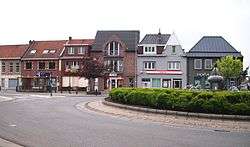
Kruishoutem
| Kruishoutem | |||
|---|---|---|---|
| Municipality | |||
 | |||
| |||
 Kruishoutem Location in Belgium | |||
|
Location of Kruishoutem in East Flanders 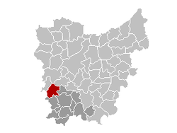 | |||
| Coordinates: 50°54′N 03°31′E / 50.900°N 3.517°ECoordinates: 50°54′N 03°31′E / 50.900°N 3.517°E | |||
| Country | Belgium | ||
| Community | Flemish Community | ||
| Region | Flemish Region | ||
| Province | East Flanders | ||
| Arrondissement | Oudenaarde | ||
| Government | |||
| • Mayor | Joop Verzele | ||
| • Governing party/ies | CD&V | ||
| Area | |||
| • Total | 46.76 km2 (18.05 sq mi) | ||
| Population (1 January 2016)[1] | |||
| • Total | 8,137 | ||
| • Density | 170/km2 (450/sq mi) | ||
| Postal codes | 9770-9772 | ||
| Area codes | 09 | ||
| Website | www.kruishoutem.be | ||

Kruishoutem (Dutch pronunciation: [ˌkrœy̯sˈɦʌu̯tɛm], in French and English Cruyshautem) is a municipality located in the Belgian province of East Flanders. The municipality comprises the towns of Kruishoutem proper, Nokere and Wannegem-Lede. On January 1, 2011, Kruishoutem had a total population of 8,140. The total area is 46.76 km² which gives a population density of 174 inhabitants per km².
The SONS Museum is located in Kruishoutem.
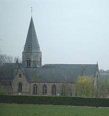
Church of Nokere
Sister cities
References
- ↑ Population per municipality as of 1 January 2016 (XLS; 397 KB)
External links
 Media related to Kruishoutem at Wikimedia Commons
- Official website (Dutch)
 |
Zulte | Deinze | Nazareth | |
| Waregem (VWV) | |
Zingem | ||
| ||||
| | ||||
| Wortegem-Petegem | Oudenaarde |
This article is issued from Wikipedia - version of the 11/30/2016. The text is available under the Creative Commons Attribution/Share Alike but additional terms may apply for the media files.