Abrest
| Abrest | ||
|---|---|---|
|
Town hall in September 2013 | ||
| ||
 Abrest | ||
|
Location within Auvergne-Rhône-Alpes region  Abrest | ||
| Coordinates: 46°05′58″N 3°26′43″E / 46.0994°N 3.4453°ECoordinates: 46°05′58″N 3°26′43″E / 46.0994°N 3.4453°E | ||
| Country | France | |
| Region | Auvergne-Rhône-Alpes | |
| Department | Allier | |
| Arrondissement | Vichy | |
| Canton | Vichy-2 | |
| Intercommunality | Vichy Val d'Allier | |
| Government | ||
| • Mayor (2014–2020) | Patrick Montagner | |
| Area1 | 10.46 km2 (4.04 sq mi) | |
| Population (2013)2 | 2,789 | |
| • Density | 270/km2 (690/sq mi) | |
| Time zone | CET (UTC+1) | |
| • Summer (DST) | CEST (UTC+2) | |
| INSEE/Postal code | 03001 / 03200 | |
| Elevation |
251–434 m (823–1,424 ft) (avg. 260 m or 850 ft) | |
| Website | ville-abrest.com | |
|
1 French Land Register data, which excludes lakes, ponds, glaciers > 1 km² (0.386 sq mi or 247 acres) and river estuaries. 2 Population without double counting: residents of multiple communes (e.g., students and military personnel) only counted once. | ||

Abrest (in occitan Abrèt) is a French commune in the Allier department in the Auvergne-Rhône-Alpes region of central France.
The commune is one of the 37 communes in the urban area of Vichy and is also part of Vichy Auvergne countryside.
Its inhabitants are called Abrestois or Abrestoises.[1]
Geography
Location
Abrest is located about 3 kilometres (1.9 mi) south of Vichy and 4 kilometres (2.5 mi) north of Saint-Yorre. The commune straddles the Allier River with the river forming the western boundary of the commune in the southern portion. Departmental road 131 traverses some hamlets of the commune on the west bank of the Allier while departmental road 906e (former D906): Avenue de Vichy and Avenue de Thiers is on the east bank and passes through the centre of the town from Vichy to Saint-Yorre. The commune also contains Mount Bourbon and Bourbon Lamagne.
Localities and Hamlets
- Right Bank: Abrest, Quinssat, Les Béarnais, Les Dollots, Les Jacquets, Les Rémondins, Les Chaussins, Les Séjournins.
- Left Bank: La Sablière, La Boire, La Tour, Les Sables.
Neighbouring Communes and Villages[2]
 |
Bellerive-sur-Allier | Vichy | Le Vernet | |
| Serbannes | |
La Chapelle | ||
| ||||
| | ||||
| Hauterive | Saint-Yorre | Arronnes |
Communications
Roads

The town is traversed by the D906e (former D906) road which links Le Puy-en-Velay, Thiers, Puy-Guillaume, and Saint-Yorre to Vichy which is the main axis of movement. Historically this road was National Highway 106 from Nimes to Saint-Gérand-le-Puy. This route is heavily used by trucks, so could be described as a problematic area.
The town is far from any motorway: the A719 motorway (which enables access to the A71) is 20 kilometres (12 mi) to the west and the A89 motorway (junction Thiers-West) is 30 kilometres (19 mi) away.
The Southwest Bypass (contournement sud-ouest), which aims to divert the flow of heavy vehicles, will be opened in 2016.[3]
- Departmental roads traversing the territory of the commune are
- D426 from Vichy to Abrest via ZA de la Croix Saint-Martin and the camp ground;
- D126 from Cusset to Abrest via Côte Saint-Amand;
- D131 from Vichy to Hauterive (along the left bank) serving the business area La Tour;
- D175 from Cusset to the D43 (63) via Le Vernet and Busset along the commune border with Le Vernet, accessible from the Quinssat road.
Public transports
Abrest is served by two of the nine lines of the transit network MobiVie:
- Route D serves the right bank (camp ground, Stadium of Graviers, the Castle, Town Hall, and the Biernets district) and runs from Monday to Saturday with four outbound and five return trips per day.
- Route G serves the left bank (district and industrial area of La Tour and Les Sables) and runs from Monday to Saturday with five runs per day.
- Custom MobiVie is a transport service on demand which is available to connect with routes B and D on the right bank, and routes B and C on the left bank.
Only the Dollots district in the south is served by the TER between Vichy and Pont-de-Dore, Thiers, and Arlanc (6 daily round trips). This service also runs on Sundays and holidays (3 return trips).
Route 55 (Vichy-Châteldon-Puy-Guillaume) of the Transdôme network serves Abrest (one round trip per day and two during the school year) serves the town centre and Dollots.[4]
Cycling
There are no cycle routes in right bank of Allier and no bicycle parkings.
Rail
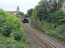
The commune has no railway station but it is traversed by two railway lines:
- Vichy–Riom railway;
- Saint-Germain-des-Fossés–Darsac railway (freight traffic only).
Urban Planning
Between 2008 and 2010, the development of Highway D906 was conducted in two phases under a communal contract for construction of the town:[5]
Firstly, in 2008 with the creation of a 30 kilometres per hour (19 mph) zone[Note 1] and road humps with a pedestrian crossing and secondly in 2009-2010, the development of the D906 road to the right of the town hall.[Note 2] The development has not altered the quality of the road: in some places the road has deteriorated due to the passage of heavy trucks, which can not take any other route.
Geology
The city is listed as a zone of low seismicity as are the majority of communes in the department.[6] Its neighbouring communes, with the exception of Brugheas, are listed at the same level.
History
The name of the commune in the form of ABRET (Latin arbor meaning "tree") was mentioned for the first time in 1301 in the Dictionary of Mr. Chazaud.[7]
Abrest was formerly a parish in the diocese of Clermont. It was fortified at the end of the 16th century and the current commune lies on both banks of the Allier. This is quite unusual because in general important rivers tend to serve as communal boundaries.
At the highest point is an old castle called Hurlevants with a view across the Allier valley and the mountains of Auvergne. The Chaussins Castle dates from the 15th century. The construction of the church dates from 1793, and as for the Town Hall, it was built in 1886.[8]
Activities in the commune
Wine: The commune was one of the main localities of the former wine coast along with Le Vernet, Creuzier-le-Vieux and to a lesser extent, Saint-Yorre and Cusset.
Jacques François Chomel in his Treatise of mineral water and baths of Vichy, appeared at Clermont in 1734 and wrote: "The wine in Vichy is good, the slopes of Abret [Abrest], of Crotte [extinct village located at the site of the Ailes district], Longevigne, the vintage of Celestins, of Ris, of Châteldon on the other side of the river Grave-la-rama [a place where Bellerive is currently], all these wines are good and are available in Paris."
The vineyards lasted until the early 20th century.
The small village of Biernets (which was written "Biernay" in the 18th century) was the most important wine village of the commune. There was a high proportion of vintners in the population (up to 70% of the population in 1750, as well as related activities such as cooperage).
The peak of the grape harvests was in the middle of the 19th century. Much of the slopes of Saint-Amand and Dollots hill were covered with vines.
The Rue des Vignes (Vines Street) and the Rue du Baril (Barrel street) are remnants of this activity.
Today, the vineyards have not completely disappeared, grapes are still cultivated a little in some places (2-3 family vineyards).
Port: Abrest was a small port on the right bank of the Allier. The impasse du Vieux-Port (Cul-de-sac of the Old Port) still bears witness. This port probably lived on a heavy traffic of wine.[9]
Heraldry
.svg.png) |
Created in 1999 by Messrs. Baujard and Deplat, holder of a Master of Plastic Art, the arms of Abrest is the symbol of the commune.
The blue line represents the Allier river which splits the commune into two parts with one side the watchtower and the other the castle.[10] Blazon: |
Politics and Administration
List of Successive Mayors of Abrest[11]
| From | To | Name | Party | Position |
|---|---|---|---|---|
| 1995 | 2009 | René Boisset | PS | |
| 2009 | 2014 | Christian Boch | DVG | Deputy Premier |
| 2014 | 2020 | Patrick Montagner[12] |
(Not all data is known)
Commune budget
Budget was in 2011:[13] €1,526,546 in investment and €1,827,154 in fonctionnement.
Population and Society
Demographic change
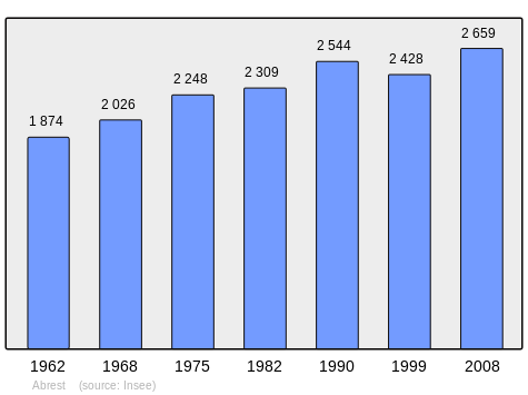
Evolution of the population of the municipality
In 2013, the commune had 2,789 inhabitants.[14] The evolution of the number of inhabitants is known through the population censuses conducted in the town since 1793. From the 21st century, a census of municipalities with fewer than 10,000 inhabitants is held every five years, unlike larger towns that have a sample survey every year.[Note 3] [Note 4]
| 1793 | 1800 | 1806 | 1821 | 1831 | 1836 | 1841 | 1846 | 1851 |
|---|---|---|---|---|---|---|---|---|
| 751 | 957 | 822 | 828 | 820 | 845 | 906 | 903 | 876 |
| 1856 | 1861 | 1866 | 1872 | 1876 | 1881 | 1886 | 1891 | 1896 |
|---|---|---|---|---|---|---|---|---|
| 866 | 860 | 919 | 913 | 887 | 868 | 875 | 834 | 803 |
| 1901 | 1906 | 1911 | 1921 | 1926 | 1931 | 1936 | 1946 | 1954 |
|---|---|---|---|---|---|---|---|---|
| 829 | 806 | 875 | 896 | 1,036 | 1,300 | 1,210 | 1,311 | 1,479 |
| 1962 | 1968 | 1975 | 1982 | 1990 | 1999 | 2006 | 2010 | 2013 |
|---|---|---|---|---|---|---|---|---|
| 1,874 | 2,026 | 2,248 | 2,309 | 2,544 | 2,428 | 2,530 | 2,732 | 2,789 |
Sources : Ldh/EHESS/Cassini until 1962, INSEE database from 1968 (population without double counting and municipal population from 2006)
Distribution of Age Groups
Percentage Distribution of Age Groups in Abrest
| Abrest | Abrest | |
|---|---|---|
| Age Range | Men | Women |
| 0 to 14 Years | 18.4 | 18.4 |
| 15 to 29 Years | 12.6 | 13.5 |
| 30 to 44 Years | 20.5 | 19.5 |
| 45 to 59 Years | 22.9 | 21.5 |
| 60 to 74 Years | 17 | 15.8 |
| 75 to 89 Years | 8.2 | 10.8 |
| 90 Years+ | 0.4 | 0.6 |
Economy
Employment
There were 1643 people aged between 15 and 64 years in 2008 in the commune which represented 74% of active people.
66.6% of active people were employed, 7.4% were unemployed.[15]
| Agricultural Workers | Artisans, Shopkeepers, Business owners | Executives and Intellectuals | Middle Managers | Employees | Workers | |
|---|---|---|---|---|---|---|
| Active Population | 4 | 78 | 58 | 288 | 366 | 370 |
| Employed Active People | 4 | 74 | 54 | 265 | 315 | 319 |
| No. of Jobs | 8 | 76 | 87 | 324 | 241 | 554 |
122 people unemployed in 2008; Unemployment rate is 10%.[15]
There are 1344 jobs in the area (1210 employees), 1103 of the people who have a job reside in the area.[15]
The rate of female employment (employees) in the agriculture sector is 100%.[15]
Businesses in the town
The commune of Abrest has a dozen companies in the business zone, ZA de la Tour, on the left bank of the Allier.
Businesses in the commune are:[16]
- Industrial: Ligier Automobiles, SAEB - Old established Barber, Brooks Instrument;
- Construction: Paving Auvergne, SOPROMECO, Guelpa, Great Central Dredging, CMV ROSSIGNOL, Industrial Constructions - Cosinus
- Trade: Gedimat, Ulimed
- Services: NSE Services, RLD 1 - Vichy.
The Abrest commune has 123 establishments around half of which are individual enterprises. 57 institutions have employees[17]).[18]
Shops
The commune of Abrest has:
- a pharmacy
- a post office
- a Banque Postale ATM
- a convenience store
- a hairdresser
- a bakery
- a tobacconnist
- three restaurants (La Colombiere, La Campagne, and Piccolino)
Culture and heritage
Civil heritage
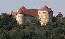

The commune has one building that is registered as a historical monument:
- The Chateau des Chaussins (14th century)
 [19]
[19]
- Other sites of interest
- 'Remains of a chateau in the town: the dovecote tower, partly rebuilt in the 19th century.
- The Chateau de Quinssat from the 17th century
- The Medieval tower of Maubet. Mentioned in the 13th century.
Religious heritage
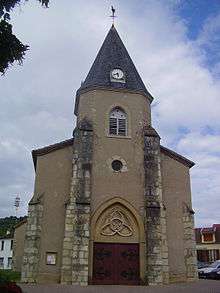
- The Church of Abrest. Originally a Gothic church, it was almost entirely rebuilt in the 19th century.
- The Old parish church of the Diocese of Clermont, fortified at the end of the 16th century.
Environmental heritage
Facilities
Since early 2006, the town has had a community centre and a municipal library located on the Avenue des Graviers - on the sloping part of the D426 - with 28 parking spaces, two for people with disabilities and reduced mobility.
The multi-purpose hall located on the right bank was rebuilt and renovated in 2009 and named Camille Claudel.
Education
The city has one public primary school located on the rue de Treuil and rue de la Croix (the development was secured in 2006 on two streets with 30 km/h zone and 1 + 3 speed humps, and in 2015).
Cultural events and festivities
Since 2001, the town of Abrest has organised an organic fair in May or June.
Every year in November, the communal staff of Abrest organize a traditional toy market.
Sports
Abrest has a football stadium, the Stade des Graviers, and a club: the US Abrest which creates promotions for the departmental district.
Notable People linked to the commune
- Louis Justin Marie, the last Marquis of Talaru Marquis and owner of the Chateau de Chaussins before the French Revolution
- André de Soixon was an important figure in Abrest. He lived a part of his life there and helped to develop the village, including rebuilding houses and helping the villagers. André de Soixon was of provincial gentry.
See also
External links
- Abrest official website (French)
- Abrest on the old IGN website (French)
- Abrest on Google Maps
- Abrest on Géoportail, National Geographic Institute (IGN) website (French)
- Abret on the 1750 Cassini Map
- Abrest on the INSEE website (French)
- INSEE (French)
Notes and references
Notes
- ↑ Since 2008, the speed was limited to 30 kilometres per hour (19 mph) without any special enactment.
- ↑ This development was followed by:
- a complete reconstruction of the roadway,
- the implementation of road humps to slow the traffic at the pedestrian crossing (2009) followed by a flattened road hump beside the town hall about 70 metres long to assist pedestrians crossing the road (2009)
- the change to the Place des Anciens-Combattants (transformation of the parking to 4 minute stops)
- the replacement of traffic lights (2010)
- the creation of a parking area with four spaces including one for disabled people in the adjoining the next building.
- ↑ At the beginning of the 21st century, the methods of identification have been modified by law No. 2002-276 of 27 February 2002 , the so-called "law of local democracy" and in particular Title V "census operations" which allow, after a transitional period running from 2004 to 2008, the annual publication of the legal population of the different French administrative districts. For municipalities with a population greater than 10,000 inhabitants, a sample survey is conducted annually, the entire territory of these municipalities is taken into account at the end of the period of five years. The first "legal population" after 1999 under this new law came into force on 1 January 2009 and was based on the census of 2006.
- ↑ In the census table and the graph, by convention in Wikipedia, and to allow a fair comparison between five yearly censuses, the principle has been retained for subsequent legal populations since 1999 displayed in the census table and the graph that shows populations for the years 2006, 2011, 2016, etc.. , as well as the latest legal population published by INSEE
References
- ↑ "Abrest (03200)". habitants.fr (in French). SARL Patagos. Retrieved 23 January 2016.
- ↑ Google Maps
- ↑ Ducros, Jean-Pierre (2014-03-03). "Peut-être fini en 2016 « sauf aléas »" [Perhaps finished in 2016 if nothing unexpected happens]. La Montagne (in French).
- ↑ Timetable of Line 55, General Council of Puy-de-Dôme (French)
- ↑ "Town Planning: 1 million for VVA". VVA Magazine (in French) (15): 15. June 2010.
- ↑ Légifrance, JORF, DEVP0823374D, Decree No. 2010-1255 of 22 October 2010 for defining the level of seismicity in French territory (French)
- ↑ Father Michel Peynot History of Saint-Yorre, Ed. Res Universalis (French)
- ↑ Last two paragraphs from the commune official website (French)
- ↑ Tixer, G. Abrest Yesterday and Today.
- ↑ Abrest Commune Official Site
- ↑ List of Mayors of France (French)
- ↑ List of Mayors of Allier on the Association of Mayors and Presidents of communities of Allier website, 8 April 2014. Retrieved 13 May 2015. (French)
- ↑ "The rate of tax revenue increases". La Montagne: 11. 2011-05-16.
- ↑ "2013 Legal populations-Abrest". INSEE (in French). Retrieved 23 January 2016.
- 1 2 3 4 5 Results of the census for the commune of Abrest, INSEE (Employment)
- ↑ Panorama of Entreprises, 2011 edition, supplement of the TV Magazine in the magazine La Montagne of 13 February 2011.
- ↑ Directory of Businesses and Institutions SIREN
- ↑ INSEE – Urban Data intra-communal by Quarter – Auvergne – Agglomeration (urban unit): Vichy
- ↑ Ministry of Culture, Mérimée PA00092966 Chateau des Chaussins (French)
| Wikimedia Commons has media related to Abrest. |