Arronnes
| Arronnes | ||
|---|---|---|
|
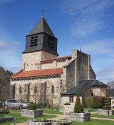
Church of St-Léger at Arronnes | ||
| ||
 Arronnes | ||
|
Location within Auvergne-Rhône-Alpes region  Arronnes | ||
| Coordinates: 46°03′32″N 3°34′10″E / 46.0589°N 3.5694°ECoordinates: 46°03′32″N 3°34′10″E / 46.0589°N 3.5694°E | ||
| Country | France | |
| Region | Auvergne-Rhône-Alpes | |
| Department | Allier | |
| Arrondissement | Vichy | |
| Canton | Lapalisse | |
| Intercommunality | Montagne Bourbonnaise | |
| Government | ||
| • Mayor (2014–2020) | François Szypula | |
| Area1 | 26 km2 (10 sq mi) | |
| Population (2013)2 | 372 | |
| • Density | 14/km2 (37/sq mi) | |
| Time zone | CET (UTC+1) | |
| • Summer (DST) | CEST (UTC+2) | |
| INSEE/Postal code | 03008 / 03250 | |
| Elevation |
330–597 m (1,083–1,959 ft) (avg. 300 m or 980 ft) | |
|
1 French Land Register data, which excludes lakes, ponds, glaciers > 1 km² (0.386 sq mi or 247 acres) and river estuaries. 2 Population without double counting: residents of multiple communes (e.g., students and military personnel) only counted once. | ||
Arronnes (Occitan, Arona) is a French commune in the Allier department in the Auvergne-Rhône-Alpes region of central France.
The inhabitants of the commune are known as Arronnais or Arronnaises.[1]
Geography
Arronnes is located some 18 kilometres (11 mi) south-east of Vichy and 6 kilometres (3.7 mi) west by south-west of Le Mayet-de-Montagne. Access to the commune is by the D995 road from Cusset in the north-west passing through the heart of the commune and the village and continuing south-east to Ferrières-sur-Sichon. Apart from the village there are the hamlets of Les Fours, Doyat, Les Barlets, and Les Etangs in the south of the commune. There are substantial forests spread over the commune occupying about 60% of the land area with the balance farmland.[2]
The Sichon river flows from the south-east to the north-west of the commune joined by its tributary the Vareille at the village and continuing north-west to join the Allier in Vichy.[2]
Neighbouring communes and villages[2]
 |
Le Vernet | La Chapelle | Nizerolles | |
| Busset | |
Le Mayet-de-Montagne | ||
| ||||
| | ||||
| Ris | Lachaux | Ferrières-sur-Sichon |
Toponymy
First named in 1282: Arona from the pre-Celtic ar ("stream" or "water") and the Gallic onna meaning river.[3]
Heraldry
.svg.png) |
Blazon: Or, a pal wavy of Azure between in chief a Phrygian helmet of Gules, to dexter a crozier of Sable, to sinister a key the same. |
Administration
List of Successive Mayors[4]
| From | To | Name | Party | Position |
|---|---|---|---|---|
| 2001 | 2020 | François Szypula[5] | UDI | Former General Councillor of the canton of Le Mayet-de-Montagne (2004–2015) |
(Not all data is known)
Demography
In 2013 the commune had 372 inhabitants.[6] The evolution of the number of inhabitants is known from the population censuses conducted in the commune since 1793. From the 21st century, a census of communes with fewer than 10,000 inhabitants is held every five years, unlike larger towns that have a sample survey every year.[Note 1]
| 1793 | 1800 | 1806 | 1821 | 1831 | 1836 | 1841 | 1846 | 1851 |
|---|---|---|---|---|---|---|---|---|
| 896 | 896 | 879 | 745 | 1,062 | 1,045 | 1,047 | 1,100 | 1,062 |
| 1856 | 1861 | 1866 | 1872 | 1876 | 1881 | 1886 | 1891 | 1896 |
|---|---|---|---|---|---|---|---|---|
| 1,057 | 1,000 | 974 | 993 | 950 | 1,014 | 1,032 | 1,042 | 927 |
| 1901 | 1906 | 1911 | 1921 | 1926 | 1931 | 1936 | 1946 | 1954 |
|---|---|---|---|---|---|---|---|---|
| 933 | 962 | 914 | 750 | 681 | 646 | 638 | 499 | 473 |
| 1962 | 1968 | 1975 | 1982 | 1990 | 1999 | 2006 | 2010 | 2013 |
|---|---|---|---|---|---|---|---|---|
| 434 | 375 | 329 | 329 | 299 | 332 | 362 | 361 | 372 |
Sources : Ldh/EHESS/Cassini until 1962, INSEE database from 1968 (population without double counting and municipal population from 2006)

Distribution of Age Groups
Percentage Distribution of Age Groups in Arronnes and Allier Department in 2010
| Arronnes | Arronnes | Allier | Allier | |
|---|---|---|---|---|
| Age Range | Men | Women | Men | Women |
| 0 to 14 Years | 17.6 | 17.6 | 16.8 | 14.7 |
| 15 to 29 Years | 11.5 | 15.4 | 15.4 | 13.6 |
| 30 to 44 Years | 16.5 | 17.0 | 18.5 | 17.2 |
| 45 to 59 Years | 28.6 | 25.3 | 21.9 | 20.9 |
| 60 to 74 Years | 15.9 | 14.8 | 17.2 | 17.8 |
| 75 to 89 Years | 9.9 | 8.8 | 9.5 | 14.1 |
| 90 Years+ | 0.0 | 1.1 | 0.6 | 1.7 |
Sources:
- Evolution and Structure of the population of the Commune in 2010, INSEE.
- Evolution and Structure of the population of the Department in 2010, INSEE.
Sites and monuments
- The Church of Saint-Léger (11th century).
 is registered as an historical monument.[7] Built in granite, it once belonged to a Benedictine priory and the monks welcomed pilgrims who crossed the Bourbonnais mountains. In the church is a Bronze Bell from 1520 which is registered as a historical object.
 [8]
[8] - A Peasant's House is located in a former farmhouse from the early 19th century.
See also
External links
- Arronnes on the National Geographic Institute website (French)
- Arronnes on Lion1906
- Arronnes on Google Maps
- Arronnes on Géoportail, National Geographic Institute (IGN) website (French)
- Aronne on the 1750 Cassini Map
- Arronnes on the INSEE website (French)
- INSEE (French)
Notes and references
Notes
- ↑ At the beginning of the 21st century, the methods of identification have been modified by Law No. 2002-276 of 27 February 2002, the so-called "law of local democracy" and in particular Title V "census operations" allows, after a transitional period running from 2004 to 2008, the annual publication of the legal population of the different French administrative districts. For communes with a population greater than 10,000 inhabitants, a sample survey is conducted annually, the entire territory of these communes is taken into account at the end of the period of five years. The first "legal population" after 1999 under this new law came into force on 1 January 2009 and was based on the census of 2006.
References
- ↑ Arronnes (03250): public services, habitants.fr, SARL Patagos (French)
- 1 2 3 Google Maps
- ↑ Bonin, Marcel (2006). Les noms de lieux en Bourbonnais [Place names in Bourbonnais] (in French). p. 17.
- ↑ List of Mayors of France (French)
- ↑ Re-elected in 2014: "Liste nominative des communes de l'Allier (avec maire, arrondissement et canton)" [Nominative list of communes of Allier (with mayor, arrondissement and canton)] (PDF). Association of Mayors and Presidents of Communities of Allier. 1 April 2015. Archived from the original (PDF) on 18 May 2015. Retrieved 13 May 2015.
- ↑ "Legal populations - Arronnes". INSEE (in French). Retrieved 23 January 2016.
- ↑ Ministry of Culture, Mérimée PA00092974 Church of Saint-Léger (French)
- ↑ Ministry of Culture, Palissy PM03000014 Bronze Bell (French)
| Wikimedia Commons has media related to Arronnes. |