Arpheuilles-Saint-Priest
| Arpheuilles-Saint-Priest | ||
|---|---|---|
|
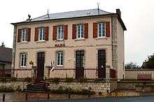
The road into Arpheuilles-Saint-Priest | ||
| ||
 Arpheuilles-Saint-Priest | ||
|
Location within Auvergne-Rhône-Alpes region  Arpheuilles-Saint-Priest | ||
| Coordinates: 46°13′32″N 2°40′43″E / 46.2256°N 2.6786°ECoordinates: 46°13′32″N 2°40′43″E / 46.2256°N 2.6786°E | ||
| Country | France | |
| Region | Auvergne-Rhône-Alpes | |
| Department | Allier | |
| Arrondissement | Montluçon | |
| Canton | Montluçon-3 | |
| Intercommunality | Pays de Marcillat-en-Combraille | |
| Government | ||
| • Mayor (2008–2020) | Jean-Paul Lamoine | |
| Area1 | 20.02 km2 (7.73 sq mi) | |
| Population (2013)2 | 351 | |
| • Density | 18/km2 (45/sq mi) | |
| Time zone | CET (UTC+1) | |
| • Summer (DST) | CEST (UTC+2) | |
| INSEE/Postal code | 03007 / 03420 | |
| Elevation |
393–543 m (1,289–1,781 ft) (avg. 340 m or 1,120 ft) | |
|
1 French Land Register data, which excludes lakes, ponds, glaciers > 1 km² (0.386 sq mi or 247 acres) and river estuaries. 2 Population without double counting: residents of multiple communes (e.g., students and military personnel) only counted once. | ||

Arpheuilles-Saint-Priest is a French commune in the Allier department in the Auvergne-Rhône-Alpes region of central France.
The inhabitants of the commune are known as Arpheuillais or Arpheuillaises.[1]
Geography
Arpheuilles-Saint-Priest is located some 14 kilometres (8.7 mi) south-east of Montluçon and some 8 kilometres (5.0 mi) south-west of Commentry. Access to the commune is by the D69 road from Durdat-Larequille in the north-east passing through the village and continuing south-east to Ronnet. The D1089 branches off the D69 just north-west of the village and continues south-west to Marcillat-en-Combraille. The D460 from Ronnet going north to join the D2144 passes through the east of the commune. Apart from the village there are the hamlets of Villenette, La Naute, and L'Harpe. Apart from a large belt of forest in the north, the commune is entirely farmland.[2]
The Banny river rises in the commune near the village and flows north-east to the Etang de la Ganne. The Ruisseau de Puy Clevaud rises near Villenette and flows south to join the Tartasse south of the commune.[2]
Neighbouring communes and villages[2]
 |
Saint-Genest | Villebret | Durdat-Larequille | |
| Mazirat | |
La Celle | ||
| ||||
| | ||||
| Terjat | Virlet | Ars-les-Favets |
History
Heraldry
.svg.png) |
Blazon: Party per pale, first Or, an oak leaf in Vert; second Gules, a harp in Argent; all surmounted in chief Azure charged with a key Or in fesse. |
Administration
List of Successive Mayors[3]
| From | To | Name | Party | Position |
|---|---|---|---|---|
| 1793 | 1795 | Jean Confession | ||
| 1795 | 1796 | Joseph Cajat | ||
| 1796 | 1820 | André Labarre | ||
| 1820 | 1821 | Hippolyte Garreau | ||
| 1821 | 1848 | Pierre Mage | ||
| 1848 | 1850 | Nicolas Aucouturier | ||
| 1850 | 1852 | Jean-Gilbert Mage | ||
| 1850 | 1852 | Perronet | ||
| 1852 | 1878 | Jean-Gilbert Mage | ||
| 1878 | 1888 | François Cajat | ||
| 1888 | 1892 | Antoine Labarre | ||
| 1892 | 1919 | Félix Lamoine | ||
| 1919 | Antonin Gaume | |||
| 2001 | 2008 | Georges Liconnet | ||
| 2008 | 2020 | Jean Paul Lamoine[4] |
(Not all data is known)
Demography
In 2013 the commune had 351 inhabitants.[5] The evolution of the number of inhabitants is known from the population censuses conducted in the commune since 1793. From the 21st century, a census of communes with fewer than 10,000 inhabitants is held every five years, unlike larger towns that have a sample survey every year.[Note 1]
| 1793 | 1800 | 1806 | 1821 | 1831 | 1836 | 1841 | 1846 | 1851 |
|---|---|---|---|---|---|---|---|---|
| 410 | 414 | 402 | 470 | 498 | 553 | 852 | 840 | 891 |
| 1856 | 1861 | 1866 | 1872 | 1876 | 1881 | 1886 | 1891 | 1896 |
|---|---|---|---|---|---|---|---|---|
| 868 | 754 | 785 | 774 | 772 | 803 | 840 | 810 | 878 |
| 1901 | 1906 | 1911 | 1921 | 1926 | 1931 | 1936 | 1946 | 1954 |
|---|---|---|---|---|---|---|---|---|
| 826 | 837 | 806 | 651 | 601 | 598 | 554 | 457 | 409 |
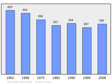
| 1962 | 1968 | 1975 | 1982 | 1990 | 1999 | 2006 | 2009 | 2013 |
|---|---|---|---|---|---|---|---|---|
| 420 | 401 | 358 | 321 | 334 | 307 | - | 337 | 351 |
Sources : Ldh/EHESS/Cassini until 1962, INSEE database from 1968 (population without double counting and municipal population from 2006)

Distribution of Age Groups


Percentage Distribution of Age Groups in Arpheuilles-Saint-Priest and Allier Department in 2009
| Arpheuilles-Saint-Priest | Arpheuilles-Saint-Priest | Allier | Allier | |
|---|---|---|---|---|
| Age Range | Men | Women | Men | Women |
| 0 to 14 Years | 14.9 | 17.0 | 16.6 | 14.5 |
| 15 to 29 Years | 16.7 | 10.3 | 15.8 | 13.7 |
| 30 to 44 Years | 19.0 | 20.0 | 18.9 | 17.4 |
| 45 to 59 Years | 26.8 | 27.9 | 22.1 | 21.1 |
| 60 to 74 Years | 14.3 | 16.3 | 16.8 | 17.6 |
| 75 to 89 Years | 8.3 | 8.5 | 9.4 | 14.0 |
| 90 Years+ | 0.0 | 0.0 | 0.6 | 1.7 |
Sources:
- Evolution and Structure of the population of the Commune in 2009, INSEE.
- Evolution and Structure of the population of the Department in 2009, INSEE.
Sites and monuments

- The Church of Saint Peter from the 19th century.
See also
External links
- Arpheuilles-Saint-Priest on the National Geographic Institute website (French)
- Arpheuilles-Saint-Priest on Lion1906
- Arpheuilles-Saint-Priest on Google Maps
- Arpheuilles-Saint-Priest on Géoportail, National Geographic Institute (IGN) website (French)
- Arpheuille on the 1750 Cassini Map
- Arpheuilles-Saint-Priest on the INSEE website (French)
- INSEE (French)
Notes and references
Notes
- ↑ At the beginning of the 21st century, the methods of identification have been modified by Law No. 2002-276 of 27 February 2002, the so-called "law of local democracy" and in particular Title V "census operations" allows, after a transitional period running from 2004 to 2008, the annual publication of the legal population of the different French administrative districts. For communes with a population greater than 10,000 inhabitants, a sample survey is conducted annually, the entire territory of these communes is taken into account at the end of the period of five years. The first "legal population" after 1999 under this new law came into force on 1 January 2009 and was based on the census of 2006.
References
- ↑ Inhabitants of Arpheuilles-Saint-Priest, habitants.fr, SARL Patagos (French)
- 1 2 3 Google Maps
- ↑ List of Mayors of France (French)
- ↑ Re-elected in 2014: "Liste nominative des communes de l'Allier (avec maire, arrondissement et canton)" [Nominative list of communes of Allier (with mayor, arrondissement and canton)] (PDF). Association of Mayors and Presidents of Communities of Allier. 1 April 2015. Archived from the original (PDF) on 18 May 2015. Retrieved 13 May 2015.
- ↑ "Legal populations - Arpheuilles-Saint-Priest". INSEE (in French). Retrieved 23 January 2016.
| Wikimedia Commons has media related to Arpheuilles-Saint-Priest. |