Busset
| Busset | |
|---|---|
|
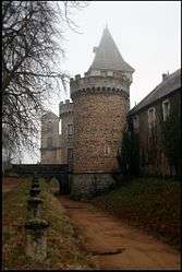
The château in Busset | |
 Busset | |
|
Location within Auvergne-Rhône-Alpes region  Busset | |
| Coordinates: 46°03′46″N 3°30′48″E / 46.0628°N 3.5133°ECoordinates: 46°03′46″N 3°30′48″E / 46.0628°N 3.5133°E | |
| Country | France |
| Region | Auvergne-Rhône-Alpes |
| Department | Allier |
| Arrondissement | Vichy |
| Canton | Lapalisse |
| Intercommunality | Vichy Val d'Allier |
| Government | |
| • Mayor (2014–2020) | Michel Aurambout |
| Area1 | 36.96 km2 (14.27 sq mi) |
| Population (2013)2 | 890 |
| • Density | 24/km2 (62/sq mi) |
| Time zone | CET (UTC+1) |
| • Summer (DST) | CEST (UTC+2) |
| INSEE/Postal code | 03045 / 03270 |
| Elevation |
265–608 m (869–1,995 ft) (avg. 500 m or 1,600 ft) |
|
1 French Land Register data, which excludes lakes, ponds, glaciers > 1 km² (0.386 sq mi or 247 acres) and river estuaries. 2 Population without double counting: residents of multiple communes (e.g., students and military personnel) only counted once. | |
Busset is a commune in the Allier department in central France.
Population
| Historical population | ||
|---|---|---|
| Year | Pop. | ±% |
| 1793 | 1,442 | — |
| 1800 | 1,480 | +2.6% |
| 1806 | 1,432 | −3.2% |
| 1821 | 1,419 | −0.9% |
| 1831 | 1,689 | +19.0% |
| 1836 | 1,700 | +0.7% |
| 1841 | 1,691 | −0.5% |
| 1846 | 1,676 | −0.9% |
| 1851 | 1,737 | +3.6% |
| 1856 | 1,647 | −5.2% |
| 1861 | 1,736 | +5.4% |
| 1866 | 1,738 | +0.1% |
| 1872 | 1,692 | −2.6% |
| 1876 | 1,738 | +2.7% |
| 1881 | 1,710 | −1.6% |
| 1886 | 1,733 | +1.3% |
| 1891 | 1,775 | +2.4% |
| 1896 | 1,680 | −5.4% |
| 1901 | 1,666 | −0.8% |
| 1906 | 1,567 | −5.9% |
| 1911 | 1,506 | −3.9% |
| 1921 | 1,314 | −12.7% |
| 1926 | 1,228 | −6.5% |
| 1931 | 1,130 | −8.0% |
| 1936 | 1,075 | −4.9% |
| 1946 | 958 | −10.9% |
| 1954 | 963 | +0.5% |
| 1962 | 976 | +1.3% |
| 1968 | 914 | −6.4% |
| 1975 | 820 | −10.3% |
| 1982 | 853 | +4.0% |
| 1990 | 881 | +3.3% |
| 1999 | 852 | −3.3% |
| 2008 | 849 | −0.4% |
| 2013 | 890 | +4.8% |
| Source: INSEE (1968–2013[1]) | ||
See also
References
- ↑ "2013 legal populations - Busset". INSEE (in French). Retrieved 1 February 2016.
| Wikimedia Commons has media related to Busset. |
This article is issued from Wikipedia - version of the 2/1/2016. The text is available under the Creative Commons Attribution/Share Alike but additional terms may apply for the media files.