Bost, Allier
| Bost | |
|---|---|
|
The church in Bost | |
 Bost | |
|
Location within Auvergne-Rhône-Alpes region  Bost | |
| Coordinates: 46°10′47″N 3°31′10″E / 46.1797°N 3.5194°ECoordinates: 46°10′47″N 3°31′10″E / 46.1797°N 3.5194°E | |
| Country | France |
| Region | Auvergne-Rhône-Alpes |
| Department | Allier |
| Arrondissement | Vichy |
| Canton | Cusset |
| Intercommunality | Vichy Val d'Allier |
| Government | |
| • Mayor (2014–2020) | Christian Catard |
| Area1 | 9.48 km2 (3.66 sq mi) |
| Population (2013)2 | 194 |
| • Density | 20/km2 (53/sq mi) |
| Time zone | CET (UTC+1) |
| • Summer (DST) | CEST (UTC+2) |
| INSEE/Postal code | 03033 / 03300 |
| Elevation |
267–429 m (876–1,407 ft) (avg. 284 m or 932 ft) |
|
1 French Land Register data, which excludes lakes, ponds, glaciers > 1 km² (0.386 sq mi or 247 acres) and river estuaries. 2 Population without double counting: residents of multiple communes (e.g., students and military personnel) only counted once. | |
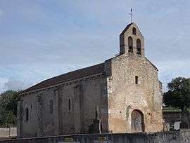
Bost is a commune in the Allier department in central France. The town is part of the Vichy urban area and boasts a twelfth century church, St-Pierre.
Population
| Historical population | ||
|---|---|---|
| Year | Pop. | ±% |
| 1962 | 182 | — |
| 1968 | 192 | +5.5% |
| 1975 | 163 | −15.1% |
| 1982 | 144 | −11.7% |
| 1990 | 153 | +6.2% |
| 1999 | 147 | −3.9% |
| 2008 | 179 | +21.8% |
| 2013 | 194 | +8.4% |
| Source: INSEE (1968–2013[1]) | ||
See also
References
- ↑ "2013 legal populations - Bost". INSEE (in French). Retrieved 1 February 2016.
| Wikimedia Commons has media related to Bost (Allier). |
This article is issued from Wikipedia - version of the 2/1/2016. The text is available under the Creative Commons Attribution/Share Alike but additional terms may apply for the media files.