Bègues
| Bègues | ||
|---|---|---|
|
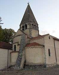
The church in Bègues | ||
| ||
 Bègues | ||
|
Location within Auvergne-Rhône-Alpes region  Bègues | ||
| Coordinates: 46°07′42″N 3°09′24″E / 46.1283°N 3.1567°ECoordinates: 46°07′42″N 3°09′24″E / 46.1283°N 3.1567°E | ||
| Country | France | |
| Region | Auvergne-Rhône-Alpes | |
| Department | Allier | |
| Arrondissement | Vichy | |
| Canton | Gannat | |
| Intercommunality | Bassin de Gannat | |
| Government | ||
| • Mayor (2014–2020) | Alain Viguié | |
| Area1 | 8.3 km2 (3.2 sq mi) | |
| Population (2013)2 | 231 | |
| • Density | 28/km2 (72/sq mi) | |
| Time zone | CET (UTC+1) | |
| • Summer (DST) | CEST (UTC+2) | |
| INSEE/Postal code | 03021 / 03800 | |
| Elevation |
290–520 m (950–1,710 ft) (avg. 525 m or 1,722 ft) | |
|
1 French Land Register data, which excludes lakes, ponds, glaciers > 1 km² (0.386 sq mi or 247 acres) and river estuaries. 2 Population without double counting: residents of multiple communes (e.g., students and military personnel) only counted once. | ||
.svg.png)
Bègues is a commune in the Allier department in central France.
Geography
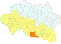 Location of Bègues in the canton of Gannat (before March 2015).
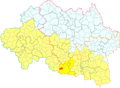 Location of Bègues in the Bassin de Gannat intercommunality.
Population
| Historical population | ||
|---|---|---|
| Year | Pop. | ±% |
| 1962 | 123 | — |
| 1968 | 150 | +22.0% |
| 1975 | 152 | +1.3% |
| 1982 | 196 | +28.9% |
| 1990 | 193 | −1.5% |
| 1999 | 202 | +4.7% |
| 2008 | 230 | +13.9% |
| 2013 | 231 | +0.4% |
| Source: INSEE (1968–2013[1]) | ||
Administration
- 2008–2014: Georges Beaumet
- 2014–2020: Alain Viguié[2]
See also
References
- ↑ "2013 legal populations - Bègues". INSEE (in French). Retrieved 24 January 2016.
- ↑ "Liste nominative des communes de l'Allier (avec maire, arrondissement et canton)" [Nominative list of communes of Allier (with mayor, arrondissement and canton)] (PDF). Association of Mayors and Presidents of Communities of Allier (in French). 1 April 2015. Archived from the original (PDF) on 18 May 2015. Retrieved 13 May 2015.
| Wikimedia Commons has media related to Bègues. |
This article is issued from Wikipedia - version of the 11/11/2016. The text is available under the Creative Commons Attribution/Share Alike but additional terms may apply for the media files.