Hérisson
| Hérisson | ||
|---|---|---|
|
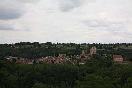
A general view of Hérisson | ||
| ||
 Hérisson | ||
|
Location within Auvergne-Rhône-Alpes region  Hérisson | ||
| Coordinates: 46°30′34″N 2°42′44″E / 46.5094°N 2.7122°ECoordinates: 46°30′34″N 2°42′44″E / 46.5094°N 2.7122°E | ||
| Country | France | |
| Region | Auvergne-Rhône-Alpes | |
| Department | Allier | |
| Arrondissement | Montluçon | |
| Canton | Huriel | |
| Intercommunality | Pays de Tronçais | |
| Government | ||
| • Mayor (2014–2020) | Bernard Faureau[1] | |
| Area1 | 32.57 km2 (12.58 sq mi) | |
| Population (2012)2 | 636 | |
| • Density | 20/km2 (51/sq mi) | |
| Time zone | CET (UTC+1) | |
| • Summer (DST) | CEST (UTC+2) | |
| INSEE/Postal code | 03127 / 03190 | |
| Elevation |
177–327 m (581–1,073 ft) (avg. 199 m or 653 ft) | |
|
1 French Land Register data, which excludes lakes, ponds, glaciers > 1 km² (0.386 sq mi or 247 acres) and river estuaries. 2 Population without double counting: residents of multiple communes (e.g., students and military personnel) only counted once. | ||
.svg.png)
For other uses, see Hérisson (disambiguation).
Hérisson is a commune in the Allier department in central France.
Population
| Historical population | ||
|---|---|---|
| Year | Pop. | ±% |
| 1962 | 916 | — |
| 1968 | 1,043 | +13.9% |
| 1975 | 979 | −6.1% |
| 1982 | 872 | −10.9% |
| 1990 | 801 | −8.1% |
| 1999 | 709 | −11.5% |
| 2008 | 676 | −4.7% |
| 2012 | 636 | −5.9% |
| Source: INSEE | ||
Notable people
- Henri Harpignies (June 28, 1819 – August 28, 1916), 19th century painter of the Barbizon school who made many pictures of Hérisson and the surroundings
- Louis Bignon (26 June 1816 - 18 May 1906), restaurateur, who made the Café Riche the most fashionable in Paris.
- Olivier Perrier (born September 15, 1940), actor, codirector of the "Théâtre des Fédérés".
Gallery
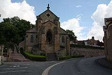 Church of Notre-Dame
.JPG) Chapelle du Calvaire
Chapelle du Calvaire_Eglise_de_Chateloy_(2).jpg) Église de Châteloy
Église de Châteloy
_Eglise_de_Chateloy_(3).jpg) Église de Châteloy: Interior
Église de Châteloy: Interior_Eglise_de_Chateloy_(5).jpg) Église de Châteloy: Freso
Église de Châteloy: Freso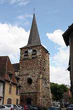 Old church of église Saint-Sauveur
 Porte de Varenne
See also
References
- ↑ "Liste nominative des communes de l'Allier (avec maire, arrondissement et canton)" [Nominative list of communes of Allier (with mayor, arrondissement and canton)] (PDF). Association of Mayors and Presidents of Communities of Allier (in French). 1 April 2015. Retrieved 1 August 2015.
| Wikimedia Commons has media related to Hérisson. |
This article is issued from Wikipedia - version of the 11/14/2016. The text is available under the Creative Commons Attribution/Share Alike but additional terms may apply for the media files.