Allouville-Bellefosse
| Allouville-Bellefosse | |
|---|---|
|
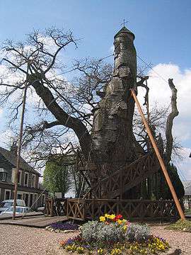
Thousand-year-old oak tree | |
 Allouville-Bellefosse | |
|
Location within Normandy region  Allouville-Bellefosse | |
| Coordinates: 49°37′27″N 0°40′37″E / 49.6241°N 0.677°ECoordinates: 49°37′27″N 0°40′37″E / 49.6241°N 0.677°E | |
| Country | France |
| Region | Normandy |
| Department | Seine-Maritime |
| Arrondissement | Rouen |
| Canton | Yvetot |
| Government | |
| • Mayor (2001–2008) | Didier Terrier |
| Area1 | 14.66 km2 (5.66 sq mi) |
| Population (2006)2 | 1,022 |
| • Density | 70/km2 (180/sq mi) |
| Time zone | CET (UTC+1) |
| • Summer (DST) | CEST (UTC+2) |
| INSEE/Postal code | 76001 / 76190 |
| Elevation |
114–154 m (374–505 ft) (avg. 148 m or 486 ft) |
|
1 French Land Register data, which excludes lakes, ponds, glaciers > 1 km² (0.386 sq mi or 247 acres) and river estuaries. 2 Population without double counting: residents of multiple communes (e.g., students and military personnel) only counted once. | |
Allouville-Bellefosse is a commune in the Seine-Maritime department in the Haute-Normandie region in northern France.
Geography
A farming village situated in the Pays de Caux, some 30 miles (48 km) northeast of Rouen at the junction of the D33, D34 and the D110 roads.
Population
| Year | 1962 | 1968 | 1975 | 1982 | 1990 | 1999 | 2006 |
|---|---|---|---|---|---|---|---|
| Population | 645 | 675 | 661 | 903 | 1007 | 986 | 1022 |
| From the year 1962 on: No double counting—residents of multiple communes (e.g. students and military personnel) are counted only once. | |||||||
Places of interest
- The church of St.Quentin, dating from the sixteenth century.
- Chêne chapelle, a 1000-year-old oak tree (the oldest in France) with a chapel built into it.
- The sixteenth-century abandoned church at Bellefosse.
- A natural history museum.
- The eighteenth-century château, in Louis XV style.
- Two manorhouses, at Bellefosse and Ismenil.
See also
References
External links
| Wikimedia Commons has media related to Allouville-Bellefosse. |
- Official website of Allouville-Bellefosse (French)
- Allouville-Bellefosse on the Quid website (French)
This article is issued from Wikipedia - version of the 10/26/2015. The text is available under the Creative Commons Attribution/Share Alike but additional terms may apply for the media files.