Grèges
"Greges" redirects here. For the botanical term, see Grex (horticulture).
| Grèges | ||
|---|---|---|
| ||
 Grèges | ||
|
Location within Normandy region  Grèges | ||
| Coordinates: 49°55′25″N 1°08′45″E / 49.9236°N 1.1458°ECoordinates: 49°55′25″N 1°08′45″E / 49.9236°N 1.1458°E | ||
| Country | France | |
| Region | Normandy | |
| Department | Seine-Maritime | |
| Arrondissement | Dieppe | |
| Canton | Dieppe-Est | |
| Intercommunality | Dieppe | |
| Government | ||
| • Mayor | Daniel Lefevre | |
| Area1 | 3.13 km2 (1.21 sq mi) | |
| Population (2006)2 | 796 | |
| • Density | 250/km2 (660/sq mi) | |
| Time zone | CET (UTC+1) | |
| • Summer (DST) | CEST (UTC+2) | |
| INSEE/Postal code | 76324 / 76370 | |
| Elevation |
74–101 m (243–331 ft) (avg. 95 m or 312 ft) | |
|
1 French Land Register data, which excludes lakes, ponds, glaciers > 1 km² (0.386 sq mi or 247 acres) and river estuaries. 2 Population without double counting: residents of multiple communes (e.g., students and military personnel) only counted once. | ||
Grèges is a commune in the Seine-Maritime department in the Haute-Normandie region in northern France.
Geography
A farming and suburban village situated in the Pays de Caux, some 2 miles (3.2 km) east of Dieppe at the junction of the D920 and the D100 roads.
Heraldry
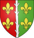 |
The arms of Grèges are blazoned : Per pale gules and vert, a pallet ?raguly? argent between 4 fleurs-de-lys Or. (the centre charge might also be blasoned 'a lopped branch palewise', as it is not what English would describe as 'raguly'. |
Population
| Year | 1962 | 1968 | 1975 | 1982 | 1990 | 1999 | 2006 |
|---|---|---|---|---|---|---|---|
| Population | 323 | 333 | 383 | 594 | 761 | 742 | 796 |
| From the year 1962 on: No double counting—residents of multiple communes (e.g. students and military personnel) are counted only once. | |||||||
Places of interest
- The church of St.Madeleine, dating from the sixteenth century.
- The ruins of a 15th-century presbytery.
See also
References
External links
| Wikimedia Commons has media related to Grèges. |
- Grèges on the Quid website (French)
This article is issued from Wikipedia - version of the 7/12/2016. The text is available under the Creative Commons Attribution/Share Alike but additional terms may apply for the media files.