Martainville-Épreville
| Martainville-Épreville | ||
|---|---|---|
|
Martainville Castle | ||
| ||
 Martainville-Épreville | ||
|
Location within Normandy region  Martainville-Épreville | ||
| Coordinates: 49°27′38″N 1°17′31″E / 49.4606°N 1.2919°ECoordinates: 49°27′38″N 1°17′31″E / 49.4606°N 1.2919°E | ||
| Country | France | |
| Region | Normandy | |
| Department | Seine-Maritime | |
| Arrondissement | Rouen | |
| Canton | Darnétal | |
| Intercommunality | Communauté de communes du Plateau de Martainville | |
| Government | ||
| • Mayor (2014–2020) | Lionel Saillard | |
| Area1 | 7.61 km2 (2.94 sq mi) | |
| Population (2011)2 | 725 | |
| • Density | 95/km2 (250/sq mi) | |
| Time zone | CET (UTC+1) | |
| • Summer (DST) | CEST (UTC+2) | |
| INSEE/Postal code | 76412 / 76116 | |
| Elevation |
138–162 m (453–531 ft) (avg. 152 m or 499 ft) | |
|
1 French Land Register data, which excludes lakes, ponds, glaciers > 1 km² (0.386 sq mi or 247 acres) and river estuaries. 2 Population without double counting: residents of multiple communes (e.g., students and military personnel) only counted once. | ||

Martainville-Épreville is a commune in the Seine-Maritime department in the Haute-Normandie region in north-western France.
Geography
A farming village, with some associated light industry, situated some 12 miles (19 km) east of Rouen at the junction of the D 85, D 13 and the N 31 (former N 30) roads.
Heraldry
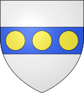 |
The arms of Martainville-Épreville are blazoned : Argent, on a fess azure, 3 bezants [Or]. |
Population
| 1962 | 1968 | 1975 | 1982 | 1990 | 1999 | 2006 | 2008 | 2011 |
|---|---|---|---|---|---|---|---|---|
| 389 | 438 | 515 | 599 | 606 | 611 | 681 | 702 | 725 |
| Starting in 1962: Population without duplicates | ||||||||
Places of interest
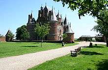
Martainville Castle
- The fifteenth-century castle, with its dovecote, gardens and a museum.
- The churches of St.Ouen and of Notre-Dame, both dating from the seventeenth century.
See also
References
External links
| Wikimedia Commons has media related to Martainville-Épreville. |
This article is issued from Wikipedia - version of the 5/21/2014. The text is available under the Creative Commons Attribution/Share Alike but additional terms may apply for the media files.