Pavilly
| Pavilly | ||
|---|---|---|
|
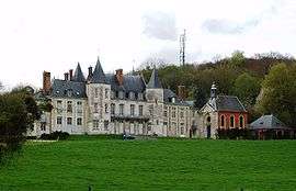
The castle Château d'Esneval | ||
| ||
 Pavilly | ||
|
Location within Normandy region  Pavilly | ||
| Coordinates: 49°34′09″N 0°57′16″E / 49.5692°N 0.9544°ECoordinates: 49°34′09″N 0°57′16″E / 49.5692°N 0.9544°E | ||
| Country | France | |
| Region | Normandy | |
| Department | Seine-Maritime | |
| Arrondissement | Rouen | |
| Canton | Pavilly | |
| Government | ||
| • Mayor | Claude Lemesle | |
| Area1 | 14.19 km2 (5.48 sq mi) | |
| Population (2006)2 | 6,158 | |
| • Density | 430/km2 (1,100/sq mi) | |
| Time zone | CET (UTC+1) | |
| • Summer (DST) | CEST (UTC+2) | |
| INSEE/Postal code | 76495 / 76570 | |
| Elevation |
50–166 m (164–545 ft) (avg. 102 m or 335 ft) | |
|
1 French Land Register data, which excludes lakes, ponds, glaciers > 1 km² (0.386 sq mi or 247 acres) and river estuaries. 2 Population without double counting: residents of multiple communes (e.g., students and military personnel) only counted once. | ||
Pavilly is a commune in the Seine-Maritime department in the Haute-Normandie region in northern France.
Geography
A town of farming and light industry situated by the banks of the Austreberthe River in the Pays de Caux, some 12 miles (19 km) northwest of Rouen at the junction of the D4, D142, D22 and the D67 roads.
Heraldry
 |
The arms of Pavilly are blazoned : Quarterly 1: Azure, a cross fleurdelysée Or; 2: Sable, a crozier reversed Or, over which a wolf couchant argent; 3: Sable, a bee argent; and 4: paly Or and azure, a chief gules. |
Population
| 1962 | 1968 | 1975 | 1982 | 1990 | 1999 | 2006 |
|---|---|---|---|---|---|---|
| 4276 | 5024 | 5593 | 5442 | 5729 | 6140 | 6158 |
| Starting in 1962: Population without duplicates | ||||||
Places of interest
- The church of Notre-Dame, dating from the thirteenth century.
- The chapel of Sainte Austreberthe, all that remains of the thirteenth century priory that was originally founded by Philibert of Jumièges.
- The fourteenth-century château Esneval, built on the foundations of a feudal castle.
People
- Saint Austrebertha, born at Thérouanne (Pas-de-Calais) in 633, died at Pavilly on February 10 704. She was the first abbess at the convent of Pavilly.
See also
References
External links
| Wikimedia Commons has media related to Pavilly. |
- Official town website (French)
- Pavilly on the Quid website (French)
This article is issued from Wikipedia - version of the 9/10/2016. The text is available under the Creative Commons Attribution/Share Alike but additional terms may apply for the media files.