Le Mesnil-sous-Jumièges
| Le Mesnil-sous-Jumièges | |
|---|---|
|
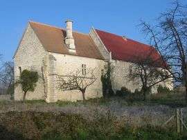
The Manor | |
 Le Mesnil-sous-Jumièges | |
|
Location within Normandy region  Le Mesnil-sous-Jumièges | |
| Coordinates: 49°24′45″N 0°51′32″E / 49.4125°N 0.8589°ECoordinates: 49°24′45″N 0°51′32″E / 49.4125°N 0.8589°E | |
| Country | France |
| Region | Normandy |
| Department | Seine-Maritime |
| Arrondissement | Rouen |
| Canton | Duclair |
| Intercommunality | Seine-Austreberthe |
| Government | |
| • Mayor (2001–2008) | Yannick Deconihout |
| Area1 | 6.84 km2 (2.64 sq mi) |
| Population (2006)2 | 633 |
| • Density | 93/km2 (240/sq mi) |
| Time zone | CET (UTC+1) |
| • Summer (DST) | CEST (UTC+2) |
| INSEE/Postal code | 76436 / 76480 |
| Elevation |
1–55 m (3.3–180.4 ft) (avg. 6 m or 20 ft) |
|
1 French Land Register data, which excludes lakes, ponds, glaciers > 1 km² (0.386 sq mi or 247 acres) and river estuaries. 2 Population without double counting: residents of multiple communes (e.g., students and military personnel) only counted once. | |
Le Mesnil-sous-Jumièges is a commune in the Seine-Maritime department in the Haute-Normandie region in northern France.
Geography
A farming village, situated in the Roumois and inside a meander of the river Seine, some 12 miles (19 km) west of Rouen on the D65 road. A ferry boat carries cars and passengers across the river to Yville-sur-Seine.
Population
| Year | 1962 | 1968 | 1975 | 1982 | 1990 | 1999 | 2006 |
|---|---|---|---|---|---|---|---|
| Population | 449 | 455 | 467 | 556 | 571 | 550 | 633 |
| From the year 1962 on: No double counting—residents of multiple communes (e.g. students and military personnel) are counted only once. | |||||||
Places of interest
- The church of St.Philibert, dating from the sixteenth century.
- The fourteenth century manor house of Agnès Sorel, mistress of Charles VII.
See also
References
External links
| Wikimedia Commons has media related to Le Mesnil-sous-Jumièges. |
- Official commune website (French)
- A history website of Le Mesnil (French)
- Le Mesnil-sous-Jumièges on the Quid website (French)
This article is issued from Wikipedia - version of the 11/29/2014. The text is available under the Creative Commons Attribution/Share Alike but additional terms may apply for the media files.