Canteleu
| Canteleu | ||
|---|---|---|
|
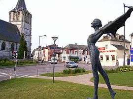
La Place Gustave Prat, Canteleu | ||
| ||
 Canteleu | ||
|
Location within Normandy region  Canteleu | ||
| Coordinates: 49°26′28″N 1°01′34″E / 49.4411°N 1.0261°ECoordinates: 49°26′28″N 1°01′34″E / 49.4411°N 1.0261°E | ||
| Country | France | |
| Region | Normandy | |
| Department | Seine-Maritime | |
| Arrondissement | Rouen | |
| Canton | Maromme | |
| Intercommunality | CREA | |
| Government | ||
| • Mayor (2008-2014) | Christophe Bouillon | |
| Area1 | 17.61 km2 (6.80 sq mi) | |
| Population (2011)2 | 14,790 | |
| • Density | 840/km2 (2,200/sq mi) | |
| Time zone | CET (UTC+1) | |
| • Summer (DST) | CEST (UTC+2) | |
| INSEE/Postal code | 76157 / 76380 | |
| Elevation |
2–138 m (6.6–452.8 ft) (avg. 128 m or 420 ft) | |
|
1 French Land Register data, which excludes lakes, ponds, glaciers > 1 km² (0.386 sq mi or 247 acres) and river estuaries. 2 Population without double counting: residents of multiple communes (e.g., students and military personnel) only counted once. | ||
Canteleu is a commune in the Seine-Maritime department in the Haute-Normandie region in north-western France.
Geography
A small town of forestry and light industry situated by the banks of the river Seine, just 2 miles (3.2 km) northwest and over the river from the centre of Rouen, at the junction of the D 51, D 982 and the D 94 roads.
Heraldry
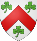 |
The arms of Canteleu are blazoned : Argent, a chevron gules between 3 trefoils vert. |
Population
| Year | 1962 | 1968 | 1975 | 1982 | 1990 | 1999 | 2006 | 2011 |
|---|---|---|---|---|---|---|---|---|
| Population | 10,278 | 13,415 | 14,174 | 15,276 | 16,090 | 15,430 | 14,206 | 14,790 |
| From the year 1962 on: No double counting—residents of multiple communes (e.g. students and military personnel) are counted only once. | ||||||||
Places of interest
- Saint-Martin’s church, dating from the thirteenth century.
- The seventeenth century convent of Sainte-Barbe, built over a cave in the cliffs, overlooking the river.
- The Flaubert museum.
- The two churches of St.Pierre, at the hamlets of Bapeaume (1872) and Croisset.
- Vestiges of a 12th-century castle at Croisset.
- A Carthaginian column in the park.
- The sixteenth century Château des Deux-Lions.
- A turretted house at Dieppedalle.
Notable people
- Gustave Flaubert (1821–1880) lived at the hamlet of Croisset for 40 years and died here.
- English painter Robert Henry Cheney (1801–1866) painted several views of and from here, including the watercolour Rouen-From the chateau de Cantelieu, July 19, 1842.
Twin towns
See also
References
Bibliography
- Alice Lejard, Canteleu aux multiples facettes, 2000 ISBN 2-9516176-0-7
- Michel Giard, Hurler avec les loups à Canteleu, Éd. Charles Corlet, 2003 ISBN 2847060774
External links
| Wikimedia Commons has media related to Canteleu. |
- Official town website (French)
- Canteleu on the Quid website (French)
This article is issued from Wikipedia - version of the 11/14/2016. The text is available under the Creative Commons Attribution/Share Alike but additional terms may apply for the media files.