Tôtes
| Tôtes | ||
|---|---|---|
| ||
 Tôtes | ||
|
Location within Normandy region  Tôtes | ||
| Coordinates: 49°40′46″N 1°02′52″E / 49.6794°N 1.0478°ECoordinates: 49°40′46″N 1°02′52″E / 49.6794°N 1.0478°E | ||
| Country | France | |
| Region | Normandy | |
| Department | Seine-Maritime | |
| Arrondissement | Dieppe | |
| Canton | Tôtes | |
| Intercommunality | Communauté de communes des Trois Rivières | |
| Government | ||
| • Mayor (2014-2020) | Jean-Yves Billoré | |
| Area1 | 7.61 km2 (2.94 sq mi) | |
| Population (2011)2 | 1,457 | |
| • Density | 190/km2 (500/sq mi) | |
| Time zone | CET (UTC+1) | |
| • Summer (DST) | CEST (UTC+2) | |
| INSEE/Postal code | 76700 / 76890 | |
| Elevation |
138–172 m (453–564 ft) (avg. 158 m or 518 ft) | |
|
1 French Land Register data, which excludes lakes, ponds, glaciers > 1 km² (0.386 sq mi or 247 acres) and river estuaries. 2 Population without double counting: residents of multiple communes (e.g., students and military personnel) only counted once. | ||
Tôtes is a commune in the Seine-Maritime department in the Haute-Normandie region in north-western France.
Geography
A farming small market town situated in the Pays de Caux, some 19 miles (31 km) south of Dieppe at the junction of the D 927 and the D 929 roads, formerly route nationale 27 and route nationale 29. Prior to the construction of the autoroute system, it was a strategically important crossroads.
Heraldry
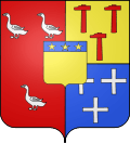 |
The arms of Tôtes are blazoned : Per pale 1: Gules, 3 geese argent and 2: per fess Or and azure, 3 hammers reversed gules and 3 crosslets argent; overall an inescutcheon Or, on a chief azure, 3 mullets of 5 Or. |
Population
| 1962 | 1968 | 1975 | 1982 | 1990 | 1999 | 2006 | 2008 | 2011 |
|---|---|---|---|---|---|---|---|---|
| 826 | 819 | 848 | 956 | 1059 | 1084 | 1285 | 1330 | 1457 |
| Starting in 1962: Population without duplicates | ||||||||
Places of interest
- The church, dating from the nineteenth century.
- The nineteenth century château.
- The Auberge du Cygne, an inn and staging post of the 15th century.
People
- Guy de Maupassant and Gustave Flaubert, French writers, stayed regularly at the inn.
Twin towns
- Bleckede, Germany, since 1977.
- Monreal del Campo, Spain
See also
References
External links
| Wikimedia Commons has media related to Tôtes. |
- Tôtes on the Quid website (French)
This article is issued from Wikipedia - version of the 7/14/2016. The text is available under the Creative Commons Attribution/Share Alike but additional terms may apply for the media files.