Bosc-Bordel
| Bosc-Bordel | |
|---|---|
 | |
 Bosc-Bordel | |
|
Location within Normandy region  Bosc-Bordel | |
| Coordinates: 49°35′39″N 1°24′40″E / 49.5942°N 1.4111°ECoordinates: 49°35′39″N 1°24′40″E / 49.5942°N 1.4111°E | |
| Country | France |
| Region | Normandy |
| Department | Seine-Maritime |
| Arrondissement | Rouen |
| Canton | Buchy |
| Government | |
| • Mayor | Jean-Pierre Rousseau |
| Area1 | 11.95 km2 (4.61 sq mi) |
| Population (2006)2 | 474 |
| • Density | 40/km2 (100/sq mi) |
| Time zone | CET (UTC+1) |
| • Summer (DST) | CEST (UTC+2) |
| INSEE/Postal code | 76120 / 76750 |
| Elevation |
192–236 m (630–774 ft) (avg. 233 m or 764 ft) |
|
1 French Land Register data, which excludes lakes, ponds, glaciers > 1 km² (0.386 sq mi or 247 acres) and river estuaries. 2 Population without double counting: residents of multiple communes (e.g., students and military personnel) only counted once. | |
Bosc-Bordel is a commune in the Seine-Maritime department in the Haute-Normandie region in northern France.
The inhabitants of the town of Bosc-Bordel are "Bordelois, Bordelois."[1]
Geography
A farming village situated in the Pays de Bray, some 22 miles (35 km) northeast of Rouen at the junction of the D7, D919 and the D38 roads.
Population
| Year | 1962 | 1968 | 1975 | 1982 | 1990 | 1999 | 2006 |
|---|---|---|---|---|---|---|---|
| Population | 339 | 361 | 337 | 385 | 401 | 440 | 443 |
| From the year 1962 on: No double counting—residents of multiple communes (e.g. students and military personnel) are counted only once. | |||||||
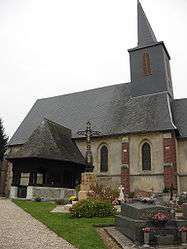
Places of interest
- The church of St.Jean-Baptiste, dating from the thirteenth century.
See also
References
External links
| Wikimedia Commons has media related to Bosc-Bordel. |
- Bosc-Bordel on the Quid website (French)
This article is issued from Wikipedia - version of the 11/6/2016. The text is available under the Creative Commons Attribution/Share Alike but additional terms may apply for the media files.