Val-de-Saâne
| Val-de-Saâne | ||
|---|---|---|
| ||
 Val-de-Saâne | ||
|
Location within Normandy region  Val-de-Saâne | ||
| Coordinates: 49°42′19″N 0°57′55″E / 49.7053°N 0.9653°ECoordinates: 49°42′19″N 0°57′55″E / 49.7053°N 0.9653°E | ||
| Country | France | |
| Region | Normandy | |
| Department | Seine-Maritime | |
| Arrondissement | Dieppe | |
| Canton | Tôtes | |
| Intercommunality | Communauté de communes des Trois Rivières | |
| Government | ||
| • Mayor (2008–2014) | Norbert Gainville | |
| Area1 | 13.87 km2 (5.36 sq mi) | |
| Population (2010)2 | 1,445 | |
| • Density | 100/km2 (270/sq mi) | |
| Time zone | CET (UTC+1) | |
| • Summer (DST) | CEST (UTC+2) | |
| INSEE/Postal code | 76018 / 76890 | |
| Elevation |
70–158 m (230–518 ft) (avg. 144 m or 472 ft) | |
|
1 French Land Register data, which excludes lakes, ponds, glaciers > 1 km² (0.386 sq mi or 247 acres) and river estuaries. 2 Population without double counting: residents of multiple communes (e.g., students and military personnel) only counted once. | ||
Val-de-Saâne is a commune in the Seine-Maritime department in the Haute-Normandie region in north-western France.
Geography
A farming commune situated by the banks of the river Saâne in the Pays de Caux, some 19 miles (31 km) south of Dieppe at the junction of the D2, D25 and the D23 roads. The commune was created in 1964 by the fusion of the four villages of Anglesqueville-sur-Saâne, Eurville, Thiédeville and Varvannes
Heraldry
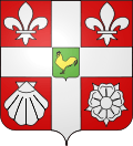 |
The arms of the commune of Val-de-Saâne are blazoned : Gules, on a cross Or between 2 fleurs-de-lys, an escallop and a rose argent, an inescutcheon vert charged with a cock Or. |
Population
| Year | 1962 | 1968 | 1975 | 1982 | 1990 | 1999 | 2006 | 2010 |
|---|---|---|---|---|---|---|---|---|
| Population | 688 | 707 | 1027 | 1214 | 1257 | 1330 | 1353 | 1445 |
| From the year 1962 on: No double counting—residents of multiple communes (e.g. students and military personnel) are counted only once. | ||||||||
Places of interest
- The church of St. Wandrille, dating from the eleventh century.
- The church of St. Sulpice, dating from the nineteenth century.
- The church of St. Nicaise, dating from the eleventh century.
- The church of St. Pierre at Eurville.
- The sixteenth-century château of Varvannes.
See also
References
External links
| Wikimedia Commons has media related to Val-de-Saâne. |
- Val-de-Saâne on the Quid website (French)
This article is issued from Wikipedia - version of the 7/14/2016. The text is available under the Creative Commons Attribution/Share Alike but additional terms may apply for the media files.