Greater Bridgeport
| Southwestern Connecticut | |
|---|---|
| Bridgeport-Stamford-Norwalk | |
 | |
| Country | United States |
| State(s) | Connecticut |
| Largest city | Bridgeport |
| Other cities |
- Stamford - Norwalk - Danbury - Stratford |
| Area | |
| • Total | 625.8 sq mi (1,621 km2) |
| Population (2015) | |
| • Total | 948,053 |
| • Rank | 57th in the U.S. |
| • Density | 1,514.9/sq mi (584.9/km2) |
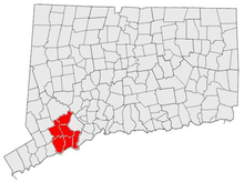
Greater Bridgeport is the metropolitan area centered on the city of Bridgeport in the U.S. state of Connecticut. The area is located in Southwestern Connecticut and consists of the city of Bridgeport and five other adjacent towns – Easton, Fairfield, Monroe, Stratford, and Trumbull. The Bridgeport area has a population of more than 305,000.
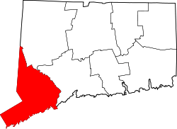
Greater Bridgeport is part of the Bridgeport-Stamford-Norwalk metropolitan statistical area, which consists of all of Fairfield County. The estimated 2015 county population was 948,053.[1]
Definitions
Greater Bridgeport Region
The smallest official definition of Greater Bridgeport is the area under the authority of the Greater Bridgeport Regional Planning Agency, which oversees transportation, land use and economic development planning for its member towns. The region consists of the six towns indicated in the introduction.[2]
Bridgeport Labor Market Area
The Bridgeport Labor Market Area includes the core region above and also extends northeast into Milford and the Lower Naugatuck Valley (including Ansonia, Beacon Falls, Derby, Oxford, Seymour, and Shelton) for a total of 13 towns.[3]
Bridgeport-Stamford NECTA
The urbanized areas of Stamford and Bridgeport are contiguous and considered by the U.S. Census Bureau as a single urban core.[4] The towns containing this merged urbanized area, plus surrounding towns with significant commuter interchange to the central towns, are grouped together as the Bridgeport-Stamford-Norwalk New England City and Town Area. The area contains 25 towns and includes the Greater Bridgeport Region, the Gold Coast, the Lower Naugatuck Valley, and the additional outlying towns of Milford, Newtown, Redding, Ridgefield, Southbury, and Woodbridge.[5] As of the 2000 census, the population of the NECTA was 892,283[6]
A slightly smaller definition known as the Southwest Service Delivery Area consists of the Greater Bridgeport Region, the Lower Naugatuck Valley (including Oxford), the Gold Coast, and the town of Milford (20 towns).[7]
Metropolitan Statistical Area
The MSA associated with Bridgeport is the Bridgeport-Stamford-Norwalk MSA and consists of the entirety of Fairfield County with 23 towns.[8] While statistically similar in terms of population and extent to the NECTA definition, the MSA includes the city of Danbury and its suburbs, and excludes the Valley region.
References
- ↑ Fairfield County QuickFacts from the US Census Bureau. Quickfacts.census.gov. Retrieved on 2016-05-30.
- ↑ Greater Bridgeport Regional Planning Agency
- ↑ Connecticut Department of Economic and Community Development - Labor Market Areas
- ↑ Urbanized area maps
- ↑ U.S. Census Bureau - Definitions of NECTAs
- ↑ U.S. Census Bureau - Population of NECTAs
- ↑ Connecticut Department of Economic and Community Development - Service Delivery Areas
- ↑ U.S. Census Bureau - Definitions of MSAs
See also
- Gold Coast (Connecticut) for the contiguous urbanized area centered on the city of Stamford
- Lower Naugatuck River Valley which is part of the Bridgeport Labor Market Area
