North Canaan, Connecticut
| North Canaan, Connecticut | ||
|---|---|---|
| Town | ||
| ||
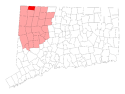 Location in Litchfield County, Connecticut | ||
| Coordinates: 42°01′21″N 73°17′27″W / 42.02250°N 73.29083°WCoordinates: 42°01′21″N 73°17′27″W / 42.02250°N 73.29083°W | ||
| Country | United States | |
| State | Connecticut | |
| NECTA | None | |
| Region | Northwestern Connecticut | |
| County | Litchfield County | |
| Incorporated | 1858 | |
| Government | ||
| • Type | Selectman-town meeting | |
| • First selectman | Douglas E. Humes, Jr. | |
| • Selectman | Charles P. Perotti | |
| • Selectman | Susan J. Clayton | |
| Area | ||
| • Total | 19.5 sq mi (50.5 km2) | |
| • Land | 19.5 sq mi (50.4 km2) | |
| • Water | 0.0 sq mi (0.0 km2) | |
| Elevation | 823 ft (251 m) | |
| Population (2005)[1] | ||
| • Total | 3,392 | |
| • Density | 174/sq mi (67/km2) | |
| Time zone | Eastern (UTC-5) | |
| • Summer (DST) | Eastern (UTC-4) | |
| ZIP code | 06018, 06024 | |
| Area code(s) | 860 | |
| FIPS code | 09-54030 | |
| GNIS feature ID | 0213478 | |
| Website | www.northcanaan.org | |
North Canaan is a town in Litchfield County, Connecticut, United States. The population was 3,350 at the 2000 census. The town center is still called "Canaan" by local residents, being the main town center of the old Town of Canaan prior to North Canaan splitting off as its own town. The Union Depot building, a former railroad station, is being restored.
Geography
According to the United States Census Bureau, the town has a total area of 19.5 square miles (50.4 km²), of which, 19.5 square miles (50.4 km²) of it is land and 0.05% is water.
Principal communities
- Canaan (village) (not the same as the town of Canaan, locally known as "Falls Village" or "South Canaan")
- Canaan Valley
- East Canaan (has its own post office)
- Sodom[2]
Demographics
| Historical population | |||
|---|---|---|---|
| Census | Pop. | %± | |
| 1860 | 1,426 | — | |
| 1870 | 1,695 | 18.9% | |
| 1880 | 1,537 | −9.3% | |
| 1890 | 1,683 | 9.5% | |
| 1900 | 1,803 | 7.1% | |
| 1910 | 2,171 | 20.4% | |
| 1920 | 1,933 | −11.0% | |
| 1930 | 2,287 | 18.3% | |
| 1940 | 2,304 | 0.7% | |
| 1950 | 2,647 | 14.9% | |
| 1960 | 2,836 | 7.1% | |
| 1970 | 3,045 | 7.4% | |
| 1980 | 3,185 | 4.6% | |
| 1990 | 3,284 | 3.1% | |
| 2000 | 3,350 | 2.0% | |
| 2010 | 3,315 | −1.0% | |
| Est. 2014 | 3,214 | [3] | −3.0% |
As of the census[5] of 2000, there were 3,350 people, 1,343 households, and 864 families residing in the town. The population density was 172.2 people per square mile (66.5/km²). There were 1,444 housing units at an average density of 74.2 per square mile (28.7/km²). The racial makeup of the town was 96.93% White, 1.19% African American, 0.18% Native American, 0.18% Asian, 0.39% from other races, and 1.13% from two or more races. Hispanic or Latino of any race were 2.36% of the population.
There were 1,343 households out of which 30.0% had children under the age of 18 living with them, 50.4% were married couples living together, 9.9% had a female householder with no husband present, and 35.6% were non-families. 30.2% of all households were made up of individuals and 13.9% had someone living alone who was 65 years of age or older. The average household size was 2.38 and the average family size was 2.98.
In the town the population was spread out with 23.3% under the age of 18, 6.7% from 18 to 24, 28.1% from 25 to 44, 22.9% from 45 to 64, and 19.0% who were 65 years of age or older. The median age was 40 years. For every 100 females there were 92.6 males. For every 100 females age 18 and over, there were 89.1 males.
The median income for a household in the town was $39,020, and the median income for a family was $52,292. Males had a median income of $34,135 versus $23,705 for females. The per capita income for the town was $18,971. About 3.3% of families and 5.8% of the population were below the poverty line, including 3.1% of those under age 18 and 5.0% of those age 65 or over.
Transportation
The main highways of the town are Route 7 (north-south) and Route 44 (east-west).
The North Canaan Union Depot, originally built in 1872, was heavily damaged by a fire in 2001 and has been under restoration by the Connecticut Railroad Historical Association since 2003. It lies along a reformed Housatonic Railroad though there is no regularly scheduled service at this time.
Education
- K-8 North Canaan Elementary School (North Canaan, CT)
- 9-12 Housatonic Valley Regional High School (Falls Village, CT)
References
- ↑ U.S. Census Bureau Population Estimates
- ↑ Douthat, Strat (Sep 26, 1992). "Connecticut's Sodom gone, but not forgotten". Gainesville Sun. pp. 6D. Retrieved 26 May 2015.
- ↑ "Annual Estimates of the Resident Population for Incorporated Places: April 1, 2010 to July 1, 2014". Retrieved June 4, 2015.
- ↑ "Census of Population and Housing". Census.gov. Retrieved June 4, 2015.
- ↑ "American FactFinder". United States Census Bureau. Retrieved 2008-01-31.
External links
| Wikimedia Commons has media related to North Canaan, Connecticut. |
- U.S. Geological Survey Geographic Names Information System: North Canaan, Connecticut
- Northwest Connecticut Arts Council
- Northwest Connecticut Convention and Visitors Bureau
- Northwestern Connecticut Community College in Winsted
- Town of North Canaan
- Town of North Canaan Land Use Regulations
- "The Beckley Blast Furnace: East Canaan, Connecticut". Library of Congress. Retrieved May 29, 2013.

Municipalities and communities of Litchfield County, Connecticut, United States | ||
|---|---|---|
| Consolidated city | 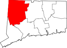 | |
| Towns | ||
| Non-consolidated city |
| |
| Boroughs | ||
| Other communities | ||