Old Saybrook, Connecticut
| Old Saybrook, Connecticut | ||
|---|---|---|
| Town | ||
|
| ||
| ||
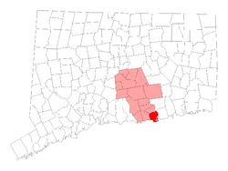 Location within Middlesex County, Connecticut | ||
| Coordinates: 41°17′38″N 72°22′57″W / 41.29389°N 72.38250°WCoordinates: 41°17′38″N 72°22′57″W / 41.29389°N 72.38250°W | ||
| Country |
| |
| State |
| |
| NECTA | New Haven | |
| Region | Connecticut River Estuary | |
| Incorporated | 1854 | |
| Government | ||
| • Type | Selectman-town meeting | |
| • First selectman | Carl P. Fortuna, Jr (R) | |
| • Selectman | Scott Geigerich (R) | |
| • Selectman | Steven Gernhardt (D) | |
| Area | ||
| • Total | 21.6 sq mi (55.9 km2) | |
| • Land | 15.0 sq mi (38.8 km2) | |
| • Water | 6.6 sq mi (17.0 km2) | |
| Elevation | 39 ft (12 m) | |
| Population (2010) | ||
| • Total | 10,242 | |
| • Density | 682.8/sq mi (263.6/km2) | |
| Time zone | Eastern (UTC-5) | |
| • Summer (DST) | Eastern (UTC-4) | |
| ZIP code | 06475 | |
| Area code(s) | 860 | |
| FIPS code | 09-57320 | |
| GNIS feature ID | 0213484 | |
| Website | http://www.oldsaybrookct.org/ | |
Old Saybrook is a town in Middlesex County, Connecticut, United States. The population was 10,242 at the 2010 census. It contains the incorporated borough of Fenwick, as well as the census-designated places of Old Saybrook Center and Saybrook Manor.
History
in 1624, shortly after establishing their first settlement at Governors Island, Dutch settlers established a short-lived factorij at present day Old Saybrook. The trading post was named Kievits Hoek, or "Plover's Corner". Kievits Hoek was soon abandoned as the Dutch consolidated settlement at New Amsterdam. In 1633, Fort Goede Hoop (Huys de Goede Hoop), was established at present-day Hartford.[1]
The Pequot siege of Saybrook Fort took place from September 1636 to March 1637 during the Pequot War.
Following the August 1636 Massachusetts Bay attack on Manisses, Pequot, and Western Niantic villages, the Pequot retaliation fell on the English at Saybrook. During an eight-month time period, the Pequot killed and wounded more than twenty English at and near Saybrook Fort. The English were attacked when they ventured far from their palisade, and the Pequot destroyed English provisions and burned warehouses while they attempted to interrupt river traffic to Windsor, Wethersfield, and Hartford. During the Siege and Battle of Saybrook Fort, the Pequot and English assessed each other's military capabilities, and adjusted counter-tactics. Each side’s tactical modifications show a high degree of sophistication, planning, and ingenuity. Lessons learned during the siege of Saybrook escalated the Pequot War in Connecticut Colony, and indirectly resulted in the attack and destruction of Mistick Fort (May 1637).
The Saybrook Colony was established in late 1635 at the mouth of the Connecticut River, in what is today Old Saybrook and environs. John Winthrop, the Younger, son of the Governor of the Massachusetts Bay Colony, was designated Governor by the group that claimed possession of the land via a deed of conveyance from Robert Rich, 2nd Earl of Warwick. Winthrop was aided by Colonel George Fenwick and Captain Lion Gardiner. As the principals of the group who had planned to settle the colony were supporters of Oliver Cromwell and remained in England during the English Civil War, the colony struggled. In 1644, Fenwick agreed to merge the colony with the more vibrant Connecticut Colony a few miles up river, which purchased the land and fort from him.
The design of the Flag of Connecticut comes from the seal of Saybrook Colony. The seal was brought from England by Colonel George Fenwick, and depicted 15 grapevines and a hand in the upper left corner with a scroll reading "Qui Transtulit Sustinet".
In 1647 Mason assumed command of Saybrook (Colony) Fort which controlled the main trade and supply route to the upper river valley. The fort promptly and mysteriously burned to the ground but another improved fort was quickly built nearby. He spent the next twelve years there and served as Commissioner of the United Colonies, as the chief military officer, magistrate and peacekeeper.
In 1659, almost all settlers from Saybrook under the leadership of Major John Mason, purchased land from Uncas, sachem of the Mohegan tribe, removed to and founded Norwich, Connecticut.[2]
On October 9, 1701 the Collegiate School of Connecticut was chartered in Old Saybrook. It moved to New Haven in 1716, and was later renamed Yale University.
Turtle - the first American submarine - was invented in Westbrook Connecticut in 1775 by David Bushnell; a replica is housed at Old Saybrook Senior High School.
The General Assembly created the separate town of Old Saybrook from Saybrook in 1852. Old Saybrook was partitioned again in 1854 when the northern part became the town of Essex.[3]
Later development
In early 2007, plans were established to return the former town hall building to its original use as a theater. The theatre was completed in 2009 and is named "Katharine Hepburn Cultural Arts Center and Theater".
The town has committed spending almost $2 million on the renovation, and at least $810,000 is to be contributed by the state. A committee is attempting to raise another $2.5 million, partly for the renovation and to add two wings, but also for an endowment. The structure was originally built in 1901 and was a theater until the 1940s. After renovations, the theater will seat 250, and Hepburn memorabilia will be displayed there.[4]
Geography
According to the United States Census Bureau, the town has a total area of 21.6 square miles (56.0 km²), of which, 15.0 square miles (39.0 km²) of it is land and 6.6 square miles (17.0 km²) of it (30.45%) is water.
Principal communities
- Chalker Beach
- Cornfield Point
- District of Fencove
- Borough of Fenwick
- District of Fenwood
- Indian Town
- Knollwood
- Old Saybrook Center (includes Saybrook Point)
- District of Otter Cove
- Saybrook Manor
- North Cove
Climate
Under the Köppen climate classification system, Old Saybrook, along with much of the eastern Connecticut coast, lies in the broad transition zone from the colder continental climates of New England and New York, to the temperate climates of the Middle Atlantic states to the south.
The warm season in Old Saybrook is from late May through mid-October. Warm and often humid weather, with highs in the 80s F and lows in the 60s F are common. Late day thundershowers are common in the hottest months, despite the mostly sunny skies. The cool/cold season is from late November though mid-March, with highs near 40 F and lows in the upper 20s F. Winter weather is far more variable than summer weather along the Connecticut coast, ranging from sunny days with high temperatures in the low 50s F to cold and blustery conditions with occasional snow. Like much of the Connecticut coast and nearby Long Island, New York, some of the winter precipitation is rain or a mix and rain and wet snow. Old Saybrook receives from one half to one third as much winter snowfall as inland Connecticut and New York State. Old Saybrook and New London average about 25 inches of snowfall annually compared to 45 inches in Hartford and 61 inches in Albany, New York.
In Old Saybrook, winter temperatures are moderated not only by Long Island Sound, but also by the Connecticut River and the large system of marshes and tidal rivers in and around its delta. The maritime influence in the area also depresses summertime temperatures (due to a sea breeze which does not reach areas further inland).
Flora
Coastal Connecticut (including Old Saybrook) is the broad transition zone where so-called "subtropical indicator" plants and other broadleaf evergreens can successfully be cultivated. Old Saybrook averages about 90 days annually with freeze (temperatures of 32 F/0 C) - about the same as Baltimore, Maryland, or Albuquerque, NM, for example. As such, Southern Magnolias, Needle Palms, Windmill palm, Loblolly Pines, and Crape Myrtles are grown in private and public gardens.
Demographics
| Historical population | |||
|---|---|---|---|
| Census | Pop. | %± | |
| 1860 | 1,105 | — | |
| 1870 | 1,215 | 10.0% | |
| 1880 | 1,302 | 7.2% | |
| 1890 | 1,484 | 14.0% | |
| 1900 | 1,431 | −3.6% | |
| 1910 | 1,516 | 5.9% | |
| 1920 | 1,463 | −3.5% | |
| 1930 | 1,643 | 12.3% | |
| 1940 | 1,985 | 20.8% | |
| 1950 | 2,499 | 25.9% | |
| 1960 | 5,274 | 111.0% | |
| 1970 | 8,468 | 60.6% | |
| 1980 | 9,287 | 9.7% | |
| 1990 | 9,552 | 2.9% | |
| 2000 | 10,367 | 8.5% | |
| 2010 | 10,242 | −1.2% | |
| Est. 2014 | 10,217 | [5] | −0.2% |
2000 U.S. Census
As of the census of 2000, there were 10,367 people, 4,184 households, and 2,920 families residing in the town. The population density was 689.5 people per square mile (266.1/km²). There were 5,357 housing units at an average density of 356.3 per square mile (137.5/km²). The racial makeup of the town was 95.75% White, 1.01% African American, 0.08% Native American, 1.72% Asian, 0.07% Pacific Islander, 0.45% from other races, and 0.93% from two or more races. Hispanic or Latino of any race were 1.87% of the population.
There were 4,184 households out of which 27.2% had children under the age of 18 living with them, 59.4% were married couples living together, 7.6% had a female householder with no husband present, and 30.2% were non-families. 25.4% of all households were made up of individuals and 12.9% had someone living alone who was 65 years of age or older. The average household size was 2.41 and the average family size was 2.90.
In the town the population was spread out with 21.7% under the age of 18, 4.1% from 18 to 24, 25.2% from 25 to 44, 27.6% from 45 to 64, and 21.5% who were 65 years of age or older. The median age was 44 years. For every 100 females there were 89.5 males. For every 100 females age 18 and over, there were 86.3 males.
The median income for a household in the town was $62,742, and the median income for a family was $72,868. Males had a median income of $48,527 versus $36,426 for females. The per capita income for the town was $30,720. About 1.5% of families and 4.5% of the population were below the poverty line, including 1.9% of those under age 18 and 9.7% of those age 65 or over.
2010 U.S. Census
As of the 2010 census, the total population was 10,242. There were 4,247 households and 2,923 families living in the town. 1,108 households had children under the age of 18. The population density was 682.8 people per square mile (263.6/km²). There were 5,602 housing units at an average density of 373.5 per square mile (144.2/km²). The racial makeup of the town was 93.9% White, .9% African American, 0.1% Native American, 2.4% Asian, 0.0003% Pacific Islander, 1.2% from other races, and 1.5% from two or more races. Hispanic or Latino of any race were 3.3% of the population.
There were 4,247 households out of which 23.7% had children under the age of 18 living with them, 56.2% were married couples living together, 7.5% had a female householder with no husband present, and 33.2% were non-families. 28.9% of all households were made up of individuals and 14.6% had someone living alone who was 65 years of age or older. The average household size was 2.21 and the average family size was 2.71.
In the town the population was spread out with 21.4% under the age of 20, 3.4% from 20 to 24, 16.4% from 25 to 44, 33.5% from 45 to 64, and 25.3% who were 65 years of age or older. The median age was 50.1 years. The population consisted of 4,852 (47.4%) males and 5,390 (52.6%) females.
The median income for a household in the town was $80,347, and the median income for a family was $97,399. Males had a median income of $74,298 versus $49,913 for females. The per capita income for the town was $43,266. About 4.5% of families and 5.9% of the population were below the poverty line, including 6.0% of those under age 18 and 4.3% of those age 65 or over.[7]
Transportation
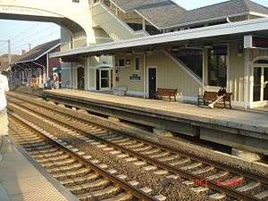
Old Saybrook's train station opened in 1873 and was rebuilt in 2002. Amtrak, the national rail passenger system, provides daily service along the Northeast Corridor to Boston, New York and points south. The high-speed Acela Express passes through Old Saybrook but does not stop; service is provided by the conventional Northeast Regional. The Connecticut Department of Transportation provides regular commuter service to New Haven and Stamford via the Shore Line East.
The Estuary Transit District provides public transportation services throughout Old Saybrook and the surrounding towns through its 9 Town Transit services.
Media
One radio station is licensed to Old Saybrook: WLIS AM 1420 (variety)
National Register of Historic Places in Old Saybrook
- Black Horse Tavern, added December 1, 1978
- Elisha Bushnell House, added November 29, 1978
- Connecticut Valley Railroad Roundhouse and Turntable Site, added April 28, 1994
- Jedidiah Dudley House, added April 12, 1982
- Samuel Eliot House, added November 9, 1972
- General William Hart House, added November 9, 1972
- James Pharmacy, added August 5, 1994
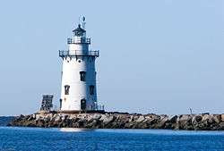
- Lynde Point Lighthouse, added May 29, 1990
- Old Saybrook South Green, added September 3, 1976
- Parker House, added November 29, 1978
- Humphrey Pratt Tavern, added November 7, 1972
- Saybrook Breakwater Lighthouse, added May 29, 1990
- William Tully House, added March 15, 1982
- Ambrose Whittlesey House, added August 23, 1985
- John Whittlesey Jr. House, added October 26, 1984
Notable people
- Lion Gardner (1599-1663)
- Major John Mason (1600-1672)
- Vin Baker (1971–) — professional basketball player in the NBA (1993–2006)
- Virginia Biddle (1910–2003) — American revue performer and showgirl
- Art Carney (1918–2003) — Academy Award- and Emmy Award-winning actor
- Katharine Hepburn (1907–2003) — Academy Award–winning actress, lived in the borough of Fenwick
- John Clellon Holmes (1926–1988) — writer and poet associated with the "Beat Generation"
- Ann Petry (1908–1997) — novelist, journalist and biographer
- Elmer Eric Schattschneider (1892–1971) — prominent political scientist and former president of the American Political Science Association
See also
- Saybrook, Illinois is named in honor of Old Saybrook.
Notes
- ↑ Tully, William B. (1884), "Town of Old Saybrook", The History of Middlesex County 1635-1885, J. H. Beers & Co., p. 282
- ↑ Caulkins, Frances Manwaring (1866). History of Norwich. p. 57.
- ↑ Connecticut Society of Genealogists: Old Saybrook
- ↑ Wojtas, Joe, "Hepburn's Town to Honor Her With a Theater", The New York Times, "Connecticut" section, page 2, February 18, 2007
- ↑ "Annual Estimates of the Resident Population for Incorporated Places: April 1, 2010 to July 1, 2014". Retrieved June 4, 2015.
- ↑ "Census of Population and Housing". Census.gov. Retrieved June 4, 2015.
- ↑ "American FactFinder: 06475". US Census Bureau. Retrieved 1 April 2013.
External links
| Wikivoyage has a travel guide for Old Saybrook. |
- Town government Web site
- Central Regional Tourism District
- Old Saybrook Historical Society
- Sustainable Saybrook Community Partnership Program
- Old Saybrook Republican Town Committee

Municipalities and communities of Middlesex County, Connecticut, United States | ||
|---|---|---|
| City |  | |
| Towns | ||
| Borough | ||
| Other communities | ||