Cornier
| Cornier | ||
|---|---|---|
|
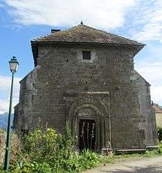
The Chapel of Moussy, in Cornier | ||
| ||
 Cornier | ||
|
Location within Auvergne-Rhône-Alpes region  Cornier | ||
| Coordinates: 46°05′37″N 6°18′02″E / 46.0936°N 6.3006°ECoordinates: 46°05′37″N 6°18′02″E / 46.0936°N 6.3006°E | ||
| Country | France | |
| Region | Auvergne-Rhône-Alpes | |
| Department | Haute-Savoie | |
| Arrondissement | Arrondissement of Bonneville | |
| Canton | Canton of La Roche-sur-Foron | |
| Intercommunality | Communauté de communes du Pays Rochois | |
| Government | ||
| • Mayor (2008–2014) | Gilbert Allard | |
| Area1 | 6.78 km2 (2.62 sq mi) | |
| Population (1999)2 | 936 | |
| • Density | 140/km2 (360/sq mi) | |
| Time zone | CET (UTC+1) | |
| • Summer (DST) | CEST (UTC+2) | |
| INSEE/Postal code | 74090 / 74800 | |
| Elevation | 453–912 m (1,486–2,992 ft) | |
| Website | Mairie-cornier.com | |
|
1 French Land Register data, which excludes lakes, ponds, glaciers > 1 km² (0.386 sq mi or 247 acres) and river estuaries. 2 Population without double counting: residents of multiple communes (e.g., students and military personnel) only counted once. | ||

Cornier is a commune in the Haute-Savoie department in the Auvergne-Rhône-Alpes region in south-eastern France.
See also
References
| Wikimedia Commons has media related to Cornier. |
This article is issued from Wikipedia - version of the 10/28/2016. The text is available under the Creative Commons Attribution/Share Alike but additional terms may apply for the media files.