Frangy
| Frangy | ||
|---|---|---|
|
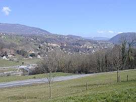
A view of Frangy from the south-west | ||
| ||
 Frangy | ||
|
Location within Auvergne-Rhône-Alpes region  Frangy | ||
| Coordinates: 46°01′11″N 5°55′50″E / 46.0197°N 5.9306°ECoordinates: 46°01′11″N 5°55′50″E / 46.0197°N 5.9306°E | ||
| Country | France | |
| Region | Auvergne-Rhône-Alpes | |
| Department | Haute-Savoie | |
| Arrondissement | Arrondissement of Saint-Julien-en-Genevois | |
| Canton | Canton of Frangy | |
| Intercommunality | Communauté de communes du Val des Usses | |
| Government | ||
| • Mayor (2014–2020) | Bernard Revillon | |
| Area1 | 9.69 km2 (3.74 sq mi) | |
| Population (1999)2 | 1,598 | |
| • Density | 160/km2 (430/sq mi) | |
| Time zone | CET (UTC+1) | |
| • Summer (DST) | CEST (UTC+2) | |
| INSEE/Postal code | 74131 / 74270 | |
| Elevation | 299–562 m (981–1,844 ft) | |
|
1 French Land Register data, which excludes lakes, ponds, glaciers > 1 km² (0.386 sq mi or 247 acres) and river estuaries. 2 Population without double counting: residents of multiple communes (e.g., students and military personnel) only counted once. | ||

Frangy is a commune in the Haute-Savoie department in the Auvergne-Rhône-Alpes region in south-eastern France.
See also
Culture and heritage
- fr:Ferme de Bel-Air, heritage protection as Monument historique since December 7, 2010. région level importance, formerly called "Inventaire Supplémentaire des Monuments Historiques" (ISMH).[1]
References
- ↑ order n°10-520 December 7, 2010.
| Wikimedia Commons has media related to Frangy. |
This article is issued from Wikipedia - version of the 10/28/2016. The text is available under the Creative Commons Attribution/Share Alike but additional terms may apply for the media files.