Cordon, Haute-Savoie
| Cordon | |
|---|---|
|
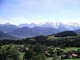
Cordon with the Mont-Blanc mountains in the background | |
 Cordon | |
|
Location within Auvergne-Rhône-Alpes region  Cordon | |
| Coordinates: 45°55′26″N 6°36′46″E / 45.9239°N 6.6128°ECoordinates: 45°55′26″N 6°36′46″E / 45.9239°N 6.6128°E | |
| Country | France |
| Region | Auvergne-Rhône-Alpes |
| Department | Haute-Savoie |
| Arrondissement | Arrondissement of Bonneville |
| Canton | Canton of Sallanches |
| Intercommunality | SIVOM Pays du Mont-Blanc |
| Government | |
| • Mayor (2008–2014) | Serge Paget |
| Area1 | 22.35 km2 (8.63 sq mi) |
| Population (2006)2 | 1,013 |
| • Density | 45/km2 (120/sq mi) |
| • Urban | 60,234 |
| Time zone | CET (UTC+1) |
| • Summer (DST) | CEST (UTC+2) |
| INSEE/Postal code | 74089 / 74700 |
| Elevation | 580–2,520 m (1,900–8,270 ft) |
|
1 French Land Register data, which excludes lakes, ponds, glaciers > 1 km² (0.386 sq mi or 247 acres) and river estuaries. 2 Population without double counting: residents of multiple communes (e.g., students and military personnel) only counted once. | |
Cordon is a commune in the Haute-Savoie department in the Auvergne-Rhône-Alpes region in south-eastern France.
See also
References
| Wikimedia Commons has media related to Cordon (Haute-Savoie). |
This article is issued from Wikipedia - version of the 10/28/2016. The text is available under the Creative Commons Attribution/Share Alike but additional terms may apply for the media files.