Kadapa district
| Kadapa district కడప జిల్లా | |
|---|---|
| District of Andhra Pradesh | |
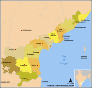
 Location of Kadapa district in Andhra Pradesh | |
| Country | India |
| State | Andhra Pradesh |
| Administrative division | Kadapa district |
| Headquarters | Kadapa |
| Tehsils | 50[1] |
| Government | |
| • Lok Sabha constituencies | Kadapa, Rajampet |
| • Assembly seats | 10 |
| Area | |
| • Total | 15,379 km2 (5,938 sq mi) |
| Population (2011) | |
| • Total | 2,884,524[2] |
| • Urban | 34.1% |
| Demographics | |
| • Literacy | 67.88% |
| • Sex ratio | 984 |
| Vehicle registration | AP-03 |
| Major highways | NH 18 |
| Coordinates | 14°28′N 78°49′E / 14.467°N 78.817°ECoordinates: 14°28′N 78°49′E / 14.467°N 78.817°E |
| Website | Official website |


Kadapa district (officially: YSR Kadapa district) is one of the 13 districts in the Indian state of Andhra Pradesh. It is also one of the four districts in the Rayalaseema region of the state. The city of Kadapa is the seat of administration for the district.[3]
History
Rock paintings
Paleolithic rock paintings found at Chintakunta caves[4] near Muddanuru in Kadapa district are said to be the second largest group of paintings in India after Bhimbetika rock art paintings. The rock paintings with mystic figures are also found at Dappalle village[5] near Mailavaram Dam in Jammalamadugu Taluk of the district.
Prehistoric Culture
Many Paleolithic sites were found in Kadapa district, as the surroundings of Jammalamadugu, Mailavaram Dam[5] and Gandikota.
Some megalithic burial sites were explored near Porumamilla, Sankhavaram and at Yellatur[6] village near Kadapa. The surroundings of Vontimitta are also noted as Megalithic cultural sites.
The section of Rayachoti consists of many documented and undocumented Megalithic sites and stone circles. A noted megalithic site is at Devandlapalli[7] in Tsundupalle taluk of the district.
Buddhism & Jainism
Kadapa has historical importance since BC era. It was connected with Mouryans in BC era and Sathavahanas. Buddhism must have flourished here for many years along the banks of rivers Cheyyeru and Penna. Nandalur[8] is an important Buddhist site in the district along with Tallapaka, Rajampeta, Konduru, Khazipeta in the district.
Jainism also had a place in Kadapa district history; the remnants of a buried Jain temple were found at Danavulapadu[9] village on the banks of river Penna.
Medieval history
It was part of the area ceded to the British by Nizam. The District was formed by splitting the Ceded Districts into two in 1808 during the British rule, the other district being Bellary.[10] The British spelt the district as Cuddapah.
The district is part of Rayalaseema, commemorating the name of Rayulu (Kings) of the Vijayanagar Empire, who ruled the area in the 16th century. Gandikota fort located on the bank of the Penna River was the citadel of Pemmasani Nayaks, commanders of Vijayanagar army and who won the battles of Raichur and Gulbarga for the Vijayanagar kings.
The old records of the district reveal that Kadapa previously called Gadapa which means in Telugu language threshold. The ancient village of Kadapa with its large tank and temple of Lord Venkateswara at Devuni Kadapa was convenient camping place for the myriads of pilgrims travelling to the holy shrine of Tirupathi. There was a belief that the pilgrims have to first visit Devuni Kadapa, before going to Tirupathi to pray to Saint Annamacharya and Saint Potuluri Veera Brahmam who foretold the future and advocated a classless society. The ancient temple at Vontimitta which inspired Pothana to compose Andhra Maha Bhagavatham is also in the district. In the olden days Kadapa was also called "Heranyanagaram".
Recent historical records reveal that in Jyothi village located in Sidhout mandal has 108 Shiva lingas on the bank of Penna river.
Geography
Kadapa District occupies an area of 15,938 square kilometres (6,154 sq mi),[11] comparatively equivalent to Canada's Prince Patrick Island.[12]
The main rivers in this district are Penna, Chitravathi, Kunderu, Papagni, Sagileru, Bahuda and Cheyyeru. The forest area is 5,050 km². It is 32.87% of the district area. It is the only district in the state of Andhra Pradesh (AP) that is surrounded by AP districts on all sides. All other districts either skirt the Bay of Bengal and/or border neighbouring states.
Economy
Besides its historical importance, the district has occupied an important place in the industrial map of Andhra Pradesh with its valuable mineral resources.
Black corson soil lands are 24%, black soil 19%, sandy soil lands 4%, red soil lands 25%. The first variety lands are very fertile, sand soil lands less so. 'Korra', orange, lime and betel leaf are the special crops. They are cultivated near river beds. Starting at Sunkesula Dam on Tungabadra river Cuddapah-Kurnool (K.C) Canal flows through Kadapa and Kurnool districts providing water to 40 km² of cultivable land. The main source of drinking water to this district is Galer-Nagari-Sujalasravanthi Canal.
This district is the repository of mineral wealth. As per the 1983 survey of geological survey of India 3 million tons of lead, 74,000,000 tons of barytes, and 27000 tons of asbestos deposits are there. It is estimated that 70 million tons of barytes deposits might be in Mangampet. There are clay deposits in Rajampet. This is used to make stone implements. Limestone is available in Yerraguntla, M/s. Coramandal Fertilizers established a cement factory with an annual yield of 1 million tons. Bharat cement corporation increased its capacity to 1 million tons. National mineral development corporation is extracting asbestos in Brahman palli and barytes in Mangampet. Kadapa is also famous for its stone called "kadapa stone" used in building construction and for slabs especially in south India. In Tummalapalle, there are 49,000 tonnes of confirmed uranium deposits which are mined and processed locally.[13][14] Zuari Cements, India Cement Ltd, Bharati Cements, Dalmia Bharat Cements, Govindaraja Textiles, Nsl Textiles, Samyu Glass, Bharati Polymers, Sajala woven shocks, Corus India Ltd are other industries.
In 2006 the Indian government named Kadapa district as one of the country's 250 most backward districts (out of a total of 640).[15] It is one of the thirteen districts in Andhra Pradesh currently receiving funds from the Backward Regions Grant Fund Programme (BRGF).[15]
Demographics
According to the 2011 census Kadapa District has a population of 2,884,524, Hindus are 83.7%, Muslims are 14% & Christians are 2.3%[16] roughly equal to the nation of Jamaica[17] or the US state of Arkansas.[18] This gives it a ranking of 132nd in India (out of a total of 640).[16] The district has a population density of 188 inhabitants per square kilometre (490/sq mi) .[16] Its population growth rate over the decade 2001–2011 was 10.87%.[16] Kadapa district has a sex ratio of 984 females for every 1000 males,[16] and a literacy rate of 67.88%.[16]
Divisions
Kadapa District has three Revenue Divisions viz., Kadapa, Rajampeta and Jammalamadugu divisions.[19] The district has 50 mandals under these revenue divisions. It also has a Municipal Corporation of Kadapa and six municipalities namely, Badvel, Mydukur, Proddatur, Pulivendula, Rayachoti, Jammalamadugu and a Nagar panchayat of Rajampet.[20][21]
There are a total of 51 mandals in Kadapa District.[22]
Mandals
The mandals are listed with respect to their revenue divisions in the following table:[19][23]
Assembly constituenties
Education
The primary and secondary school education is imparted by government, aided and private schools, under the School Education Department of the state.[24][25] As per the school information report for the academic year 2015-16, there are a total of 4,488 schools. They include, 22 government, 3,094 mandal and zilla parishads, 1 residential, 1,181 private, 10 model, 29 Kasturba Gandhi Balika Vidyalaya (KGBV), 88 municipal and 63 other types of schools.[26] The total number of students enrolled in primary, upper primary and high schools of the district are 401,293.[27]
There are a good number of schools, degree colleges, engineering colleges and universities. These include IIIT at Idupulapaya, Yogi Vemana University at Kadapa, KSRM College of Engineering, RIMS College of Dentals and Govt.Hospitals, JNTU-A College of Engineering at Pulivendula, Sri Venkateswara Veterinary College at Proddatur, Yogi vemana Engineering College at Proddatur, and Hyderabad Public School at Kadapa.
Tourist locations

The district is home to many tourist locations which include temples and forts, each with its own unique design and architecture and its own history.[28][29]
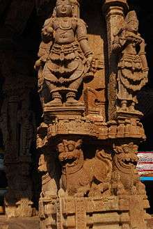
- Vontimitta - The town is famous for the temple of Sri Kodandarama Swamy temple, a Hindu temple dedicated to the god Rama, located in Vontimitta in Korajampet taluk of Kadapa District in the Indian state of Andhra Pradesh. The temple, an example of Vijayanagara architectural style, is dated to the 16th century. It is stated to be the largest temple in the region.[2][3][4][5] It is located at a distance of 25 kilometres (16 mi) from Kadapa and is close to Rajampet.[6]
- Rayachoty - Rayachoty is known for the temple of Sri Veerabhadra Swamy Temple which was renovated by Srikrishna Devaraya in 14th century.
- Nandalur - Nandalur is famous for the temple of Sri Soumyanatha Swamy.An ancient Buddhist site is located on a small hill near Nandalur called Lanja Kanuma Gutta.
- Tallapaka - Tallapaka is the birthplace of Tallapaaka Annamacharya a renowned Telugu poet and ardent devotee of Lord Venkateshwara, often regarded as Telugu Padakavita Pitamaha.
- Gandikota - Gandikota is a well-known historical place, where several historical monuments are located and some movies are shot here, like Maryada Ramanna, Ek Veera and Super Cowboy, etc.
- Bramham Gari Matham - The place where the manuscripts of Pothuluru Virabrahmendra Swami are kept.
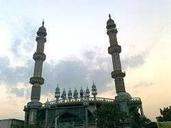
- Ameen Peer Dargah - A 324-year-old Sufi shrine in the city of Kadapa.
- Sri Lankamalleswara Wildlife Sanctuary - A wildlife sanctuary headquartered in the city of Kadapa which is the only home of an endangered species called the Jerdon's courser.
Notable personalities
- Tallapaka Annamacharya
- Pothuluri Veerabrahmam a well-known saint and astronomer, often called as 'Nostradamus of India'
- Dr. YS Rajasekhara Reddy Chief minister of Andhra Pradesh state (2004-2009)
- Allasani Peddana One of the poets in Astdiggajalu in Srikrishnadevarayalu.
- Bhaktha Kannappa
- Molla (poet) Poet.
- C.P. Brown A Telugu author, he also worked as a collector.
- B. Nagi Reddy South Indian film producer
- B. Padmanabham Veteran film comedian and producer
- Bomireddi Narasimha Reddy (B. N. Reddy), famous film Director
- Pasupuleti Kannamba first generation Telugu heroine and producer, famous for sword fights.
- Santha Kumari, an Indian musical artist and film actress
- Dr. Yaga Venugopal Reddy, better known as Y. V. Reddy, former Reserve Bank of India Governor
- Justice K. Jayachandra Reddy Former Supreme Court Judge, Former National Law Commission Chairman, Former Press Council of India Chairman, Member of the Expert Group appointed by United Nations.
- A. V. S. Reddy former AP State Election Commissioner
- V. N. Reddy an Indian cinematographer
- Yogi Vemana, popularly known as Vemana, was a great Telugu philosopher and poet. His poems were written in Telugu, and are known for their use of simple language and native idioms. His poems discuss the subjects of Yoga, wisdom and morality. He is popularly called Yogi Vemana, in recognition of his success in the path of Yoga.
Transport
The total of core road network of the district is 1,130.906 km (702.712 mi). It includes, 714.317 km (443.856 mi) of existing and a proposed length of 416.589 km (258.856 mi).[30]
Education
The primary and secondary school education is imparted by government, aided and private schools, under the School Education Department of the state.[31][32] The total number of students enrolled in primary, upper primary and high schools of the district are 400,697.[33]
References
- ↑ "District - Guntur". Andhra Pradesh Online Portal. Retrieved 23 August 2014.
- ↑ "District profile". AP State Portal. Retrieved 20 July 2014.
- ↑ "Districts". Government of AP. Retrieved 22 May 2015.
- ↑ Subramanyam, M.V. (25 July 2012). "Second largest rock art painting site explored". The Hindu. Chennai, India.
- 1 2 http://asi.nic.in/nmma_reviews/Indian%20Archaeology%201976-77%20A%20Review.pdf
- ↑ "Comprehensive History and Culture of Andhra Pradesh: Pre- and protohistoric ...". google.co.in.
- ↑ "Megalithic burial site found in Kadapa". The Hindu. Chennai, India. 24 June 2012.
- ↑ http://asi.nic.in/nmma_reviews/Indian%20Archaeology%201979-80%20A%20Review.pdf
- ↑ "Archaeological Survey of India". ap.nic.in.
- ↑ The Imperial Gazetteer of India, Volume 7. Oxford: Clarendon Press. 1908. pp. 158–176.
- ↑ Srivastava, Dayawanti et al. (ed.) (2010). "States and Union Territories: Andhra Pradesh: Government". India 2010: A Reference Annual (54th ed.). New Delhi, India: Additional Director General, Publications Division, Ministry of Information and Broadcasting (India), Government of India. pp. 1111–1112. ISBN 978-81-230-1617-7.
- ↑ "Island Directory Tables: Islands by Land Area". United Nations Environment Program. 18 February 1998. Retrieved 11 October 2011.
Prince Patrick Island 15,848
- ↑ "Tummalapalle uranium mill to start operation by March 2011". Article from the Times of India. WISE Uranium Project. 24 October 2010. Retrieved 19 July 2011.
- ↑ "India: 'Massive' uranium find in Andhra Pradesh". BBC News – South Asia. BBC. 19 July 2011. Retrieved 19 July 2011.
- 1 2 Ministry of Panchayati Raj (8 September 2009). "A Note on the Backward Regions Grant Fund Programme" (PDF). National Institute of Rural Development. Retrieved 27 September 2011.
- 1 2 3 4 5 6 "District Census 2011". Census2011.co.in. 2011. Retrieved 30 September 2011.
- ↑ US Directorate of Intelligence. "Country Comparison:Population". Retrieved 1 October 2011.
Jamaica 2,868,380 July 2011 est
- ↑ "2010 Resident Population Data". U.S. Census Bureau. Retrieved 30 September 2011.
Arkansas 2,915,918
- 1 2 "Revenue Divisions". National Informatics Centre. Retrieved 22 May 2015.
- ↑ "Andhra Pradesh Municipalities Reservation of Chairperson in Municipal Councils and Nagar Panchayats". Tgnns.com. Government of Andhra Pradesh. Retrieved 19 February 2015.
- ↑ "Municipal Websites". Commissioner and Director of Municipal Administration. Government of Andhra Pradesh. Retrieved 19 February 2015.
- ↑ "Mandals in Kadapa district" (PDF). AP State Portal. Retrieved 20 July 2014.
- ↑ "District Revenue Divisions and Mandals". Y.S.R.-District Panchayat. National Informatics Centre. Retrieved 7 November 2014.
- ↑ "School Education Department" (PDF). School Education Department, Government of Andhra Pradesh. Retrieved 7 November 2016.
- ↑ "The Department of School Education - Official AP State Government Portal". www.ap.gov.in. Retrieved 7 November 2016.
- ↑ "School Information Report". Commissionerate of School Education. Government of Andhra Pradesh. Retrieved 8 November 2016.
- ↑ "Student Information Report". Commissionerate of School Education. Child info 2015-16, District School Education - Andhra Pradesh. Retrieved 8 November 2016.
- ↑ Welcome to Frontline : Vol. 29 :: No. 10. Hinduonnet.com. Retrieved on 20 May 2012.
- ↑ Welcome to Frontline : Vol. 29 :: No. 10. Hinduonnet.com. Retrieved on 20 May 2012.
- ↑ ":: APRDC ::". Andhra Pradesh Road Development Corporation. Roads and Buildings Department. Retrieved 9 November 2016.
- ↑ "School Education Department" (PDF). School Education Department, Government of Andhra Pradesh. Retrieved 7 November 2016.
- ↑ "The Department of School Education - Official AP State Government Portal | AP State Portal". www.ap.gov.in. Retrieved 7 November 2016.
- ↑ "Student Information Report". Commissionerate of School Education. Child info 2015-16, District School Education - Andhra Pradesh. Retrieved 8 November 2016.
External links
| Wikimedia Commons has media related to Kadapa district. |
 |
Kurnool district | Prakasam district | | |
| Anantapur district | |
Nellore district | ||
| ||||
| | ||||
| Chittoor district |
| Topics | 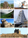 | |
|---|---|---|
| Regions | ||
| Districts | ||
| Million-plus cities | ||
| Cities (population over 1 lakh) | ||
| Tourism |
| |
| Related lists |
| |
| ||