Fujinomiya, Shizuoka
| Fujinomiya 富士宮市 | |||
|---|---|---|---|
| City | |||
|
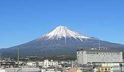
Mount Fuji and Fujinomiya City Office | |||
| |||
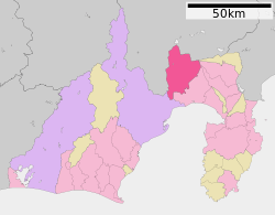 Location of Fujinomiya in Shizuoka Prefecture | |||
 Fujinomiya
| |||
| Coordinates: 35°13′19.6″N 138°37′17.8″E / 35.222111°N 138.621611°ECoordinates: 35°13′19.6″N 138°37′17.8″E / 35.222111°N 138.621611°E | |||
| Country | Japan | ||
| Region | Chūbu (Tōkai) | ||
| Prefecture | Shizuoka Prefecture | ||
| Government | |||
| • -Mayor | Naoyoshi Komuro | ||
| Area | |||
| • Total | 389.08 km2 (150.22 sq mi) | ||
| Population (September 2015) | |||
| • Total | 130,298 | ||
| • Density | 337/km2 (870/sq mi) | ||
| Time zone | Japan Standard Time (UTC+9) | ||
| - Tree | Maple | ||
| - Flower | Fujizakura | ||
| - Bird | Euasian skylark | ||
| - Fish | Rainbow trout | ||
| Phone number | 0544-22-1119 | ||
| Address | 150 Yumizawachō, Fujinomiya-shi, Shizuoka-ken 418-8601 | ||
| Website |
www | ||


Fujinomiya (富士宮市 Fujinomiya-shi) is a city located in central Shizuoka Prefecture, Japan.
As of September 2015, the city had an estimated population of 130,928 and a population density of 337 persons per km². The total area was 388.99 square kilometres (150.19 sq mi).
Geography
Fujinomiya is located in central Shizuoka Prefecture on an upland plateau on the foothills and lower slopes of Mount Fuji with an altitude ranging from 35 meters to 3336 meters. The average temperature is 15.6 deg C. Much of the city lies within the borders of the Fuji-Hakone-Izu National Park.
Fujinomiya is known as one of the main starting points for climbing trips to Mount Fuji, the summit of which is partly within the borders of the city. As with most of Shizuoka Prefecture, the area enjoys a warm maritime climate with hot, humid summers and mild, cool winters.
Surrounding municipalities
- Shizuoka Prefecture
- Yamanashi Prefecture
History
Fujinomiya is an ancient settlement, developing as a market town associated with the Ichinomiya, or supreme Shinto shrine of Suruga Province, the Fujisan Hongū Sengen Taisha (富士山本宮浅間大社). It was also a post town (fortified during the Sengoku period) on the primary route connecting Suruga with Kai Province. During the Edo period, the area was tenryō territory under direct control of the Tokugawa shogunate. British consul Sir Rutherford Alcock made the first recorded ascent on Mount Fuji by a non-Japanese person from Fujinomiya in 1860. During the cadastral reform of the early Meiji period in 1889, the area was reorganized into Omiya Town and eight villages with Fuji District, Shizuoka.
The modern city was established on June 1, 1942 with the merger of Omiya Town with neighoring Fujioka Village. The city expanded by annexing neighboring Fujine village in 1955, and Kitayama, Shiraito, Kamiide and Ueno villages in 1956.
The most recent merger was on March 23, 2010, when the town of Shibakawa (from Fuji District) was merged into Fujinomiya.
Economy
Fujinomiya is an industrial center within Shizuoka Prefecture, traditionally with a heavy emphasis on the paper industry. Other manufacturing industries include rotating equipment, chemicals and pharmaceuticals.
Education
Fujinomiya has 21 elementary schools, 13 public and one private middle schools, and four public and two private high schools.
Transportation
Rail
- JR Central - Minobu Line
- Gendōji - Fujinomiya - Nishi-Fujinomiya - Numakubo - Shibakawa - Inako
Highway
Bus
- Fuji Kyūkō
- Fuji-Kyū Shizuoka Bus
- Sankō town coach
- Fujinomiya Station - Tokyo International Airport Express Bus
- Fujinomiya Station - Tokyo Station Express Bus
- Kyoto/Osaka line Express Bus
Sister city relations
-
 Santa Monica, California, United States[1] since July 21, 1975
 -
 Shaoxing, Zhejiang Province, China,[2] since November 11, 1997
Local attractions
- Fujinomiya is famous for yakisoba noodles (富士宮やきそば Fujinomiya yakisoba)
- Mount Fuji
- Fujisan Hongū Sengen Taisha
- Shiraito Falls
- Asagiri Plateau
- Lake Tanuki
Festivals
- Hatsumōde (Fujisan Hongū Sengen Taisha)
- Yabusame (Horseback archery) Festival (May 4, 5, 6)
- Oyamabiraki (opening of climbing season) July 1
- Gojinka-festival (August)
- Fujinomiya Autumn Festival (November 3, 4, 5)
Events
- The 13th World Scout Jamboree was held August 2–10, 1971 on Asagiri Heights on the western side of Mount Fuji.
- The 9th ISF Women's World Championship was held in Fujinomiya, in 1998.
Noted people from Fujinomiya
- Kumiko Akiyoshi - actress
- Mizuki Sano - singer
- Kōtarō Satomi - actor
- Kaori Shimizu - singer
- Takahiro Yamada (Asian Kung-Fu Generation)
- Masaaki Sawanobori - professional soccer player
- Shinsuke Tayama - Olympic athlete
- Toshie Uematsu - professional wrestler
- Yasuhiro Hiraoka - professional soccer player
- Yutaka Yoshida - professional soccer player
- Hirotsugu Akaike - statistician
Gallery
 Fujinomiya City
 Climbing Mount Fuji-Fujinomiya routes
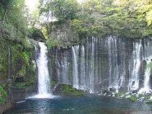 Shiraito Falls
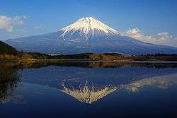 Lake Tanuki
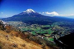 Asagiri Plateau
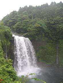 Otodome Falls
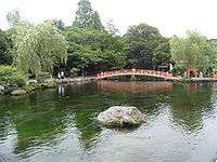 Wakutama Springs of Mount Fuji
 Fujinomiya yakisoba
References
- ↑ "US-Japan Sister Cities by State". Asia Matters for America. Honolulu, HI: East-West Center. Retrieved 20 November 2015.
- ↑ "International Exchange". List of Affiliation Partners within Prefectures. Council of Local Authorities for International Relations (CLAIR). Retrieved 21 November 2015.
External links
- Official website
- Official Shizuoka Prefecture homepage
- FUJISAN HONGU SENGENTAISHA official website
- Mount Fuji Fujinomiya Trail Climbing Guide
- Mount Fuji Fujinomiya Trail Climbing Guide
- Fujinomiya info
| Wikimedia Commons has media related to Fujinomiya, Shizuoka. |
| Wikivoyage has a travel guide for Fujinomiya. |
| Wards of Shizuoka | ||
|---|---|---|
| Wards of Hamamatsu | ||
| Special cities | ||
| Other cities | ||
| Kamo District | ||
| Tagata District | ||
| Suntō District | ||
| Haibara District | ||
| Shūchi District | ||