Hararghe
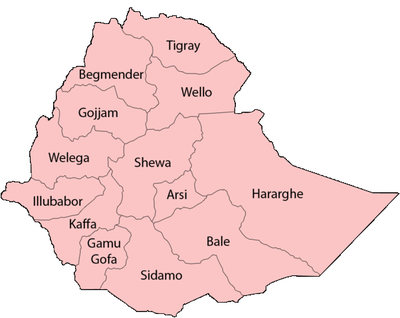
Hararghe (Amharic: ሐረርጌ?; Harari: ሐረርጌይ, Oromo: Harargee, Somali: Xararge) was a province in the eastern part of Ethiopia, with its capital in Harar. Including Ethiopia's part of the Ogaden, Haraghe was bounded on the south by Sidamo, southwest by Arsi, west by Shewa, northwest by Wollo, northeast by French Somaliland, and on the east by Somalia.
Hararghe came into existence as a result of Proclamation 1943/1, which created 12 taklai ghizats from the existing 42 provinces of varying sizes.[1] A comparison of the two maps in Margary Perham, The Government of Ethiopia shows that Hararghe was created by combining the Aussa Sultanate, the lands of the Issa, Gadabuursi, and the Ogaden, with the 1935 provinces of Chercher and Harar.[2] In 1960, the province south of the Shebelle River was made into its own province, Bale.[3] With the adoption of the new constitution in 1995, Hararghe was divided between the Oromia, Harari, Afar and Somali Regions, forming a large part of the latter.
References
- ↑ Bereket Habte Selassie, "Constitutional Development in Ethiopia", Journal of African Law, 10 (1966), p. 79.
- ↑ Perham, The Government of Ethiopia, second edition (London: Faber and Faber, 1969), maps 1 and 2
- ↑ Paul B. Henze, Layers of Time, A History of Ethiopia (New York: Palgrave, 2000), p. 238
Coordinates: 8°N 43°E / 8°N 43°E