San Mateo County, California
| San Mateo County, California | ||||||||
|---|---|---|---|---|---|---|---|---|
| County | ||||||||
| County of San Mateo | ||||||||
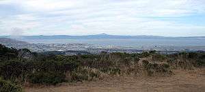
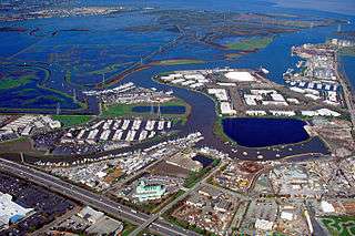
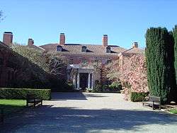
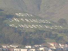
Images, from top down, left to right: A view of San Francisco Bay from the San Francisco Bay Discovery Site, Port of Redwood City, San Bruno Mountain State Park, the historic Filoli Mansion, South San Francisco Hillside Sign, Montara State Beach | ||||||||
| ||||||||
| Motto: All of California in One County | ||||||||
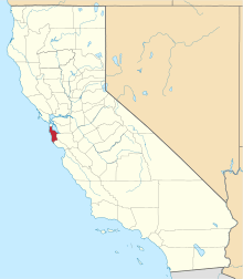 Location in the state of California | ||||||||
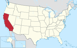 California's location in the United States | ||||||||
| Coordinates: 37°26′N 122°22′W / 37.44°N 122.36°WCoordinates: 37°26′N 122°22′W / 37.44°N 122.36°W | ||||||||
| Country |
| |||||||
| State |
| |||||||
| Region | San Francisco Bay Area | |||||||
| Incorporated | 19 April 1856[1] | |||||||
| Named for | Saint Matthew (English translation) | |||||||
| County seat | Redwood City | |||||||
| Largest city |
Daly City (population) Redwood City (area) | |||||||
| Area | ||||||||
| • Total | 744 sq mi (1,930 km2) | |||||||
| • Land | 448 sq mi (1,160 km2) | |||||||
| • Water | 293 sq mi (760 km2) | |||||||
| Highest elevation[2] | 2,603 ft (793 m) | |||||||
| Population (April 1, 2010)[3] | ||||||||
| • Total | 718,451 | |||||||
| • Estimate (2015)[3] | 765,135 | |||||||
| • Density | 1,693/sq mi (654/km2) | |||||||
| Time zone | Pacific Time Zone (UTC-8) | |||||||
| • Summer (DST) | Pacific Daylight Time (UTC-7) | |||||||
| Area codes | 415/628, 650 | |||||||
| FIPS code | 06-081 | |||||||
| GNIS feature ID | 277305 | |||||||
| Website |
www | |||||||


San Mateo County (/ˌsæn məˈteɪ.oʊ/ SAN mə-TAY-oh; Spanish for "Saint Matthew") is a county located in the U.S. state of California. As of the 2010 census, the population was 718,451.[3] The county seat is Redwood City.[4]
San Mateo County is included in the San Francisco-Oakland-Hayward, CA Metropolitan Statistical Area, and is part of the San Francisco Bay Area, the nine counties bordering San Francisco Bay. It covers most of the San Francisco Peninsula. San Francisco International Airport is located at the northern end of the county, and Silicon Valley begins at the southern end. The county's built-up areas are mostly suburban with some areas being very urban, and are home to several corporate campuses.
History
San Mateo County was formed in 1856 after San Francisco County, one of the state's 18 original counties since California's statehood in 1850, was split apart. Until 1856, San Francisco's city limits extended west to Divisadero Street and Castro Street, and south to 20th Street. In response to the lawlessness and vigilantism that escalated rapidly between 1855 and 1856, the California government decided to divide the county. A straight line was then drawn across the tip of the San Francisco Peninsula just north of San Bruno Mountain. Everything south of the line became the new San Mateo County while everything north of the line became the new consolidated City and County of San Francisco, to date the only consolidated city-county in California.[5][6] The consolidated city-county of San Francisco was formed by a bill introduced by Horace Hawes, signed by the governor on 19 April 1856. San Mateo County was officially organized on 18 April 1857 under a bill introduced by Senator T.G. Phelps. The 1857 bill defined the southern boundary of San Mateo County as following the south branch of San Francisquito Creek to its source in the Santa Cruz Mountains and thence due west to the Pacific Ocean, and named Redwood City as the county seat.[7] San Mateo County then annexed part of northern Santa Cruz County in March 1868, including Pescadero and Pigeon Point.[5][7]
Although the forming bill named Redwood City the county seat, a May 1856 election marked by "unblushing frauds ... perpetuated on an unorganized and wholly unprotected community by thugs and ballot stuffers from San Francisco" named Belmont the county seat.[8] The election results were declared illegal and the county government was moved to Redwood City, with land being donated from the original Pulgas Grant for the county government on 27 February 1858.[8] Redwood City's status as county seat was upheld in two succeeding elections in May 1861 and 9 December 1873, defeating San Mateo and Belmont.[8] Another election in May 1874 named San Mateo the county seat, but the state supreme court overturned that election on 24 February 1875 and the county seat has been in Redwood City since.[8]
San Mateo County bears the Spanish name for Saint Matthew. As a place name, San Mateo appears as early as 1776 and several local geographic features were also designated San Mateo on early maps including variously: a settlement, an arroyo, a headland jutting into the Pacific (Point Montara), and a large land holding (Rancho San Mateo). Until about 1850, the name appeared as San Matheo.
Geography
According to the U.S. Census Bureau, the county has a total area of 741 square miles (1,920 km2), of which 448 square miles (1,160 km2) is land and 293 square miles (760 km2) (40%) is water.[9] It is the third-smallest county in California by land area. A number of bayside watercourses drain the eastern part of the county including San Bruno Creek and Colma Creek. Streams draining the western county include Frenchmans Creek, Pilarcitos Creek, Naples Creek, Arroyo de en Medio, and Denniston Creek. These streams originate along the northern spur of the Santa Cruz Mountains that run through the county. The northern and north-east parts of the county are very heavy densely populated with largely urban and suburban areas, with many of its cities as edge-cities for the Bay Area, whilst the deep south and the west central parts of the county are less heavy densely populated with more rural environment and coastal beaches areas.
Features
San Mateo County straddles the San Francisco Peninsula, with the Santa Cruz Mountains running its entire length. The county encompasses a variety of habitats including estuarine, marine, oak woodland, redwood forest, coastal scrub and oak savannah. There are numerous species of wildlife present, especially along the San Francisco Bay estuarine shoreline, San Bruno Mountain, Fitzgerald Marine Reserve and the forests on the Montara Mountain block. Several creeks discharge to the San Francisco Bay including San Mateo Creek and Laurel Creek and several coastal streams discharge to the Pacific Ocean such as Frenchmans Creek and San Vicente Creek.
Año Nuevo State Marine Conservation Area and Greyhound Rock State Marine Conservation Area are two adjoining marine protected areas off the coast of San Mateo County. Like underwater parks, these marine protected areas help conserve ocean wildlife and marine ecosystems.
Flora and fauna
The county is home to several endangered species including the San Francisco garter snake and the San Bruno elfin butterfly, both of which are endemic to San Mateo County. The endangered California clapper rail is also found on the shores of San Francisco Bay, in the cities of Belmont and San Mateo. The endangered wildflower Hickman's potentilla is found near the Pacific Ocean on the lower slopes of Montara Mountain. The endangered wildflowers White-rayed pentachaeta, Pentachaeta bellidiflora, San Mateo Woolly Sunflower, Eriophyllum latilobum, Marin Dwarf Flax, Hesperolinon congestum and the San Mateo Thornmint, Acanthomintha duttonii, are found in the vicinity of the Crystal Springs Reservoir.
In May 2014, a California condor was spotted near Pescadero, a coastal community south of San Francisco[10]—it was the first California condor spotted in San Mateo County since 1904.[10] The Condor, tagged with the number "597," and also known as "Lupine", is one of 439 condors living in the wild or captivity in California, Baja California and Arizona.[10][11] The three-year-old female flew more than 100 miles (160 km) north from Pinnacles National Park, in San Benito County, on May 30, and landed on a private, forested property near Pescadero, on the San Mateo County Coast, where it was photographed by a motion-activated wildlife camera.[10] Harold Heath, Professor Emeritus, of Stanford University was responsible for the 1904 sighting, 1 mile (1.6 km) west of the University campus.[10][12]
National protected areas
- Don Edwards San Francisco Bay National Wildlife Refuge (part)
- Golden Gate National Recreation Area (part)
Marine protected area
County trails
See this county page for trail descriptions.
- Alpine Trail
- Bog Trail
- Cañada Trail
- Crystal Springs Trail
- Edgewood Trail
- Ralston Trail
- San Andreas Trail
- Sand Hill Trail
- Sawyer Camp Trail
- Skyline Trail
- Sheep Camp Trail
- Sweeney Ridge Trail
- Hiking trails in San Mateo County
County parks
- Coyote Point Recreation Area
- Coyote Point Marina
- Crystal Springs
- Edgewood Park and Natural Reserve
- Fitzgerald Marine Reserve
- Flood Park (County)
- Heritage Grove
- Huddart Park
- Junipero Serra County Park
- Pescadero Creek Park
- Russian Ridge Open Space Preserve
- Sam MacDonald Park
- San Bruno Mountain (County Park)
- San Mateo Fishing Pier
- San Mateo County Memorial Park
- San Pedro Valley County Park
- Sanchez Adobe
- Woodside Store
- Wunderlich Park (New)[13]
State parks
- Año Nuevo State Park
- Butano State Park
- Castle Rock State Park
- Heritage Grove
- Portola Redwoods State Park
- Quarry Park
- Burleigh H. Murray Ranch
- Pigeon Point Light Station Historic State Park
- Point Montara Light Station State Park
- Portola Redwoods State Park
- San Bruno Mountain State Park
State beaches
- Año Nuevo State Reserve
- Bean Hollow State Beach
- Big Basin State Beach
- Gray Whale Cove State Beach
- Half Moon Bay State Beach
- Montara State Beach
- Pacifica State Beach
- Pebble Beach
- Pescadero State Beach
- Pomponio State Beach
- San Gregorio State Beach
- Thornton State Beach
Demographics
San Mateo County had one of the largest Tongan communities outside of Tonga, with an estimated 13,000 Tongan Americans.[14]
2011
| Population, race, and income | |||||
|---|---|---|---|---|---|
| Total population[15] | 711,622 | ||||
| White[15] | 424,219 | 59.6% | |||
| Black or African American[15] | 20,507 | 2.9% | |||
| American Indian or Alaska Native[15] | 2,469 | 0.3% | |||
| Asian[15] | 175,098 | 24.6% | |||
| Native Hawaiian or other Pacific Islander[15] | 10,556 | 1.5% | |||
| Some other race[15] | 47,756 | 6.7% | |||
| Two or more races[15] | 31,017 | 4.4% | |||
| Hispanic or Latino (of any race)[16] | 177,003 | 24.9% | |||
| Per capita income[17] | $45,346 | ||||
| Median household income[18] | $87,633 | ||||
| Median family income[19] | $104,370 | ||||
Places by population, race, and income
| Places by population and race | ||||||||
|---|---|---|---|---|---|---|---|---|
| Place | Type[20] | Population[15] | White[15] | Other[15] [note 1] |
Asian[15] | Black or African American[15] |
Native American[15] [note 2] |
Hispanic or Latino (of any race)[16] |
| Atherton | Town | 6,883 | 84.8% | 4.1% | 10.0% | 0.2% | 0.9% | 5.1% |
| Belmont | City | 25,568 | 66.6% | 8.1% | 22.4% | 2.5% | 0.3% | 12.2% |
| Brisbane | City | 4,179 | 57.9% | 13.0% | 25.6% | 1.0% | 2.5% | 25.1% |
| Broadmoor | CDP | 4,229 | 45.1% | 14.9% | 38.0% | 1.0% | 0.9% | 22.5% |
| Burlingame | City | 28,514 | 70.9% | 6.8% | 20.2% | 1.4% | 0.7% | 11.9% |
| Colma | Town | 1,785 | 32.2% | 21.8% | 44.0% | 1.3% | 0.7% | 40.0% |
| Daly City | City | 100,556 | 27.0% | 13.4% | 55.0% | 3.0% | 1.6% | 24.2% |
| East Palo Alto | City | 28,077 | 54.3% | 15.5% | 3.0% | 17.5% | 9.8% | 62.1% |
| El Granada | CDP | 4,683 | 91.5% | 6.2% | 2.0% | 0.3% | 0.0% | 9.3% |
| Emerald Lake Hills | CDP | 4,273 | 86.3% | 1.8% | 10.9% | 1.0% | 0.0% | 4.6% |
| Foster City | City | 30,133 | 46.1% | 6.1% | 45.2% | 2.0% | 0.7% | 6.4% |
| Half Moon Bay | City | 11,228 | 84.7% | 10.4% | 3.7% | 1.1% | 0.0% | 29.8% |
| Highlands-Baywood Park | CDP | 4,198 | 65.5% | 10.5% | 23.1% | 0.5% | 0.4% | 5.9% |
| Hillsborough | Town | 10,748 | 67.8% | 5.3% | 26.0% | 0.6% | 0.2% | 2.1% |
| Ladera | CDP | 1,649 | 95.8% | 1.6% | 2.5% | 0.0% | 0.0% | 3.7% |
| La Honda | CDP | 1,035 | 92.5% | 4.3% | 2.6% | 0.3% | 0.3% | 6.9% |
| Loma Mar | CDP | 72 | 79.2% | 20.8% | 0.0% | 0.0% | 0.0% | 0.0% |
| Menlo Park | City | 31,669 | 73.1% | 9.9% | 10.2% | 6.0% | 0.9% | 18.1% |
| Millbrae | City | 21,275 | 52.6% | 5.8% | 39.2% | 1.9% | 0.4% | 13.7% |
| Montara | CDP | 2,739 | 88.6% | 5.1% | 6.3% | 0.0% | 0.0% | 11.2% |
| Moss Beach | CDP | 2,439 | 82.3% | 17.2% | 0.3% | 0.2% | 0.1% | 27.2% |
| North Fair Oaks | CDP | 14,666 | 70.1% | 22.6% | 4.0% | 1.7% | 1.6% | 74.3% |
| Pacifica | City | 37,043 | 67.3% | 10.1% | 19.5% | 2.2% | 0.9% | 17.1% |
| Pescadero | CDP | 514 | 64.4% | 35.6% | 0.0% | 0.0% | 0.0% | 48.6% |
| Portola Valley | Town | 4,326 | 92.4% | 1.5% | 5.9% | 0.0% | 0.2% | 6.2% |
| Redwood City | City | 76,031 | 75.0% | 10.3% | 10.6% | 2.7% | 1.3% | 37.3% |
| San Bruno | City | 40,677 | 52.9% | 14.6% | 26.3% | 2.4% | 3.8% | 28.0% |
| San Carlos | City | 28,130 | 82.1% | 6.7% | 10.3% | 0.5% | 0.3% | 9.0% |
| San Mateo | City | 95,957 | 65.3% | 10.4% | 19.8% | 2.3% | 2.1% | 25.0% |
| South San Francisco | City | 62,822 | 41.5% | 16.8% | 35.9% | 2.4% | 3.5% | 33.7% |
| West Menlo Park | CDP | 3,600 | 84.0% | 3.7% | 10.2% | 2.2% | 0.0% | 5.6% |
| Woodside | Town | 5,263 | 91.1% | 4.0% | 4.4% | 0.2% | 0.4% | 6.6% |
| Places by population and income | |||||
|---|---|---|---|---|---|
| Place | Type[20] | Population[21] | Per capita income[17] | Median household income[18] | Median family income[19] |
| Atherton | Town | 6,883 | $128,816 | $250,001 | $250,001 |
| Belmont | City | 25,568 | $51,115 | $100,417 | $130,208 |
| Brisbane | City | 4,179 | $50,977 | $79,129 | $104,798 |
| Broadmoor | CDP | 4,229 | $31,315 | $74,091 | $113,491 |
| Burlingame | City | 28,514 | $52,634 | $79,760 | $109,592 |
| Colma | Town | 1,785 | $29,912 | $80,972 | $84,605 |
| Daly City | City | 100,556 | $28,649 | $75,399 | $83,722 |
| East Palo Alto | City | 28,077 | $18,014 | $50,137 | $49,974 |
| El Granada | CDP | 4,683 | $59,351 | $125,960 | $168,015 |
| Emerald Lake Hills | CDP | 4,273 | $82,988 | $172,619 | $176,250 |
| Foster City | City | 30,133 | $53,384 | $115,053 | $131,421 |
| Half Moon Bay | City | 11,228 | $47,909 | $96,208 | $120,357 |
| Highlands-Baywood Park | CDP | 4,198 | $64,366 | $144,167 | $174,464 |
| Hillsborough | Town | 10,748 | $121,336 | $222,131 | $240,568 |
| Ladera | CDP | 1,649 | $96,569 | $192,917 | $225,375 |
| La Honda | CDP | 1,035 | $59,889 | $155,707 | $161,250 |
| Loma Mar | CDP | 72 | $63,633 | $101,250 | [22] |
| Menlo Park | City | 31,669 | $68,967 | $111,244 | $156,473 |
| Millbrae | City | 21,275 | $41,515 | $83,992 | $101,710 |
| Montara | CDP | 2,739 | $63,411 | $140,408 | $141,224 |
| Moss Beach | CDP | 2,439 | $50,354 | $104,219 | $134,491 |
| North Fair Oaks | CDP | 14,666 | $22,273 | $53,868 | $50,480 |
| Pacifica | City | 37,043 | $42,933 | $93,436 | $105,198 |
| Pescadero | CDP | 514 | $43,372 | $142,548 | $143,413 |
| Portola Valley | Town | 4,326 | $131,950 | $170,208 | $246,111 |
| Redwood City | City | 76,031 | $39,927 | $77,111 | $88,525 |
| San Bruno | City | 40,677 | $34,102 | $77,468 | $83,432 |
| San Carlos | City | 28,130 | $60,313 | $118,865 | $156,085 |
| San Mateo | City | 95,957 | $45,248 | $86,772 | $107,023 |
| South San Francisco | City | 62,822 | $31,563 | $75,543 | $84,027 |
| West Menlo Park | CDP | 3,600 | $78,879 | $132,009 | $183,355 |
| Woodside | Town | 5,263 | $120,069 | $222,986 | $243,563 |
2010
| Historical population | |||
|---|---|---|---|
| Census | Pop. | %± | |
| 1860 | 3,214 | — | |
| 1870 | 6,635 | 106.4% | |
| 1880 | 8,669 | 30.7% | |
| 1890 | 10,087 | 16.4% | |
| 1900 | 12,094 | 19.9% | |
| 1910 | 26,585 | 119.8% | |
| 1920 | 36,781 | 38.4% | |
| 1930 | 77,405 | 110.4% | |
| 1940 | 111,782 | 44.4% | |
| 1950 | 235,659 | 110.8% | |
| 1960 | 444,387 | 88.6% | |
| 1970 | 556,234 | 25.2% | |
| 1980 | 587,329 | 5.6% | |
| 1990 | 649,623 | 10.6% | |
| 2000 | 707,161 | 8.9% | |
| 2010 | 718,451 | 1.6% | |
| Est. 2015 | 765,135 | [23] | 6.5% |
| U.S. Decennial Census[24] 1790–1960[25] 1900–1990[26] 1990–2000[27] 2010–2015[3] | |||
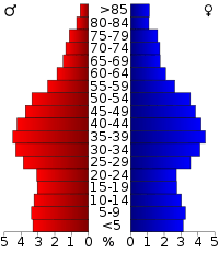
The 2010 United States Census reported that San Mateo County had a population of 718,451. The racial makeup of San Mateo County was 383,535 (53.4%) White, 20,436 (2.8%) African American, 3,306 (0.5%) Native American, 178,118 (24.8%) Asian (9.8% Filipino, 9.0% Chinese, 1.9% Indian, 1.2% Japanese, 0.8% Korean, 0.5% Vietnamese, 0.3% Burmese, 0.1% Pakistani), 10,317 (1.4%) Pacific Islander (0.6% Tongan, 0.3% Samoan, 0.2% Fijian, 0.1% Native Hawaiian), 84,529 (11.8%) from other races, and 38,210 (5.3%) from two or more races. Hispanic or Latino of any race were 182,502 persons (25.4%); 15.7% of San Mateo County is Mexican, 2.7% Salvadoran, 1.2% Guatemalan, 1.2% Nicaraguan, 0.7% Peruvian, 0.6% Puerto Rican, 0.2% Colombian, and 0.2% Cuban.[28]
|
| Population reported at 2010 United States Census | |||||||||
|---|---|---|---|---|---|---|---|---|---|
Population | American | American | | Islander | races | more races | or Latino (of any race) | ||
| San Mateo County | 718,451 | 383,535 | 20,436 | 3,306 | 178,118 | 10,317 | 84,529 | 38,210 | 182,502 |
cities and towns | Population | American | American | | Islander | races | more races | or Latino (of any race) | |
| Atherton | 6,914 | 5,565 | 75 | 7 | 911 | 45 | 95 | 216 | 268 |
| Belmont | 25,835 | 17,455 | 423 | 72 | 5,151 | 198 | 964 | 1,572 | 2,977 |
| Brisbane | 4,282 | 2,578 | 80 | 21 | 1,084 | 41 | 182 | 296 | 712 |
| Burlingame | 28,806 | 19,510 | 360 | 74 | 5,841 | 139 | 1,451 | 1,431 | 3,966 |
| Colma | 1,792 | 620 | 59 | 7 | 619 | 9 | 366 | 112 | 708 |
| Daly City | 101,123 | 23,842 | 3,600 | 404 | 56,267 | 805 | 11,236 | 4,969 | 23,929 |
| East Palo Alto | 28,155 | 8,104 | 4,704 | 120 | 1,057 | 2,118 | 10,694 | 1,358 | 18,147 |
| Foster City | 30,567 | 13,912 | 576 | 29 | 13,746 | 189 | 575 | 1,540 | 1,995 |
| Half Moon Bay | 11,324 | 8,580 | 82 | 71 | 490 | 9 | 1,710 | 382 | 3,563 |
| Hillsborough | 10,825 | 7,178 | 42 | 7 | 3,044 | 23 | 109 | 422 | 373 |
| Menlo Park | 32,026 | 22,494 | 1,551 | 156 | 3,157 | 454 | 2,776 | 1,438 | 5,902 |
| Millbrae | 21,532 | 10,177 | 179 | 33 | 9,205 | 214 | 776 | 948 | 2,555 |
| Pacifica | 37,234 | 24,166 | 976 | 206 | 7,230 | 315 | 1,703 | 2,638 | 6,243 |
| Portola Valley | 4,353 | 3,960 | 12 | 5 | 242 | 1 | 29 | 104 | 175 |
| Redwood City | 76,815 | 46,255 | 1,881 | 511 | 8,216 | 795 | 14,967 | 4,190 | 29,810 |
| San Bruno | 41,114 | 20,350 | 942 | 246 | 10,423 | 1,377 | 5,075 | 2,701 | 12,016 |
| San Carlos | 28,406 | 22,497 | 233 | 65 | 3,267 | 70 | 827 | 1,447 | 2,855 |
| San Mateo | 97,207 | 56,214 | 2,296 | 505 | 18,384 | 1,998 | 12,264 | 5,546 | 25,815 |
| South San Francisco | 63,632 | 23,760 | 1,625 | 395 | 23,293 | 1,111 | 9,598 | 3,850 | 21,645 |
| Woodside | 5,287 | 4,717 | 23 | 4 | 332 | 4 | 63 | 144 | 243 |
places | Population | American | American | | Islander | races | more races | or Latino (of any race) | |
| Broadmoor | 4,176 | 1,705 | 100 | 30 | 1,676 | 44 | 359 | 262 | 981 |
| El Granada | 5,467 | 4,608 | 45 | 38 | 190 | 5 | 336 | 245 | 813 |
| Emerald Lake Hills | 4,278 | 3,655 | 39 | 5 | 322 | 15 | 56 | 186 | 288 |
| Highlands-Baywood Park | 4,027 | 2,657 | 53 | 9 | 1,017 | 17 | 47 | 227 | 306 |
| Ladera | 928 | 811 | 13 | 0 | 16 | 2 | 18 | 68 | 69 |
| La Honda | 1,426 | 1,269 | 3 | 1 | 98 | 0 | 5 | 50 | 33 |
| Loma Mar | 113 | 101 | 2 | 0 | 3 | 0 | 0 | 7 | 12 |
| Montara | 2,909 | 2,491 | 16 | 21 | 142 | 1 | 97 | 141 | 324 |
| Moss Beach | 3,103 | 2,280 | 25 | 43 | 118 | 9 | 494 | 134 | 903 |
| North Fair Oaks | 14,687 | 7,060 | 235 | 143 | 548 | 219 | 5,728 | 754 | 10,731 |
| Pescadero | 643 | 314 | 2 | 2 | 5 | 1 | 294 | 25 | 402 |
| West Menlo Park | 3,659 | 2,983 | 28 | 2 | 416 | 4 | 52 | 174 | 201 |
communities | Population | American | American | | Islander | races | more races | or Latino (of any race) | |
| All others not CDPs (combined) | 15,806 | 11,667 | 156 | 74 | 1,608 | 85 | 1,583 | 633 | 3,542 |
2000
As of the census of 2009,[30] there were 714,936 people, 258,648 households, and 174,582 families residing in the county. The population density was 2,753/sq mi (825/km²). There were 284,471 housing units at an average density of 789/sq mi (432/km²). 7.4% were of Italian, 7.1% Irish, 7.0% German and 5.3% English ancestry according to Census 2000. 46.9% spoke English, 28.4% Spanish, 6.2% Tagalog, 4.0% Chinese or Mandarin and 1.1% Cantonese, and other language 4.2%, as their first language from estimate census 2009.
There were 258,648 households out of which 30% had children under the age of 18, 48.6% were married couples living together, 14.7% had a female householder with no husband present, and 41.7% were non-families. 31.5% of all households were made up of individuals and 6.2% had someone living alone who was 65 years of age or older. The average household size was 3.79 and the average family size was 4.44.
In the county, the population was spread out with 28.6% under the age of 18, 15.9% from 18 to 24, 25.8% from 25 to 44, 21% from 45 to 64, and 9.7% who were 65 years of age or older. The median age was 31 years. For every 100 females there were 97.8 males. For every 100 females age 18 and over, there were 95.1 males.
The median income for a household in the county was $69,306, and the median income for a family was $77,737. Males had a median income of $48,342 versus $45,383 for females. The per capita income for the county was $36,045. About 6.42% of families and 9.51% of the population were below the poverty line, including 10.01% of those under age 18 and 8.52% of those age 65 or over.
Government
San Mateo County has a five-member Board of Supervisors, representing five geographic districts, elected at-large until November 2012. On November 6, 2012, Measure B passed[31] to amend the San Mateo County Charter so that each member of the Board of Supervisors will cease to be elected by an at-large vote of all the voters in the County, but is instead elected only by the voters of his or her district.[32]
San Mateo County is split between California's 14th and 18th congressional districts, represented by Jackie Speier (D–Hillsborough) and Anna Eshoo (D–Atherton), respectively.[33]
In the California State Assembly, San Mateo County is split between three legislative districts:[34]
- the 19th Assembly District, represented by Democrat Phil Ting,
- the 22nd Assembly District, represented by Democrat Kevin Mullin, and
- the 24th Assembly District, represented by Democrat Marc Berman.
In the California State Senate, San Mateo is split between the 11th and 13th districts, represented by Scott Wiener and Jerry Hill, respectively.[35]
Politics
Voter registration
| Population and registered voters | ||
|---|---|---|
| Total population[15] | 711,622 | |
| Registered voters[36][note 3] | 360,786 | 50.7% |
| Democratic[36] | 185,134 | 51.3% |
| Republican[36] | 69,925 | 19.4% |
| Democratic–Republican spread[36] | +115,209 | +31.9% |
| Independent[36] | 7,693 | 2.1% |
| Green[36] | 2,521 | 0.7% |
| Libertarian[36] | 1,852 | 0.5% |
| Peace and Freedom[36] | 735 | 0.2% |
| Americans Elect[36] | 14 | 0.0% |
| Other[36] | 754 | 0.2% |
| No party preference[36] | 92,158 | 25.5% |
Cities by population and voter registration
| Cities by population and voter registration | |||||||
|---|---|---|---|---|---|---|---|
| City | Population[15] | Registered voters[36] [note 3] |
Democratic[36] | Republican[36] | D–R spread[36] | Other[36] | No party preference[36] |
| Atherton | 6,883 | 72.7% | 31.9% | 41.1% | -9.2% | 5.1% | 23.8% |
| Belmont | 25,568 | 59.4% | 49.4% | 20.8% | +28.6% | 6.3% | 25.8% |
| Brisbane | 4,179 | 57.8% | 54.9% | 12.8% | +42.1% | 7.0% | 27.5% |
| Burlingame | 28,514 | 56.1% | 48.5% | 22.3% | +26.2% | 5.8% | 25.6% |
| Colma | 1,785 | 35.0% | 59.1% | 10.6% | +48.5% | 6.7% | 26.0% |
| Daly City | 100,556 | 38.8% | 55.6% | 12.3% | +43.3% | 4.9% | 29.0% |
| East Palo Alto | 28,077 | 30.3% | 64.4% | 8.7% | +55.7% | 4.9% | 23.5% |
| Foster City | 30,133 | 51.3% | 45.2% | 21.2% | +24.0% | 4.6% | 30.7% |
| Half Moon Bay | 11,228 | 58.3% | 47.3% | 22.6% | +24.7% | 7.7% | 24.9% |
| Hillsborough | 10,748 | 66.9% | 31.8% | 39.5% | -7.7% | 5.2% | 25.5% |
| Menlo Park | 31,669 | 57.1% | 50.6% | 21.5% | +29.1% | 4.8% | 24.7% |
| Millbrae | 21,275 | 54.0% | 47.9% | 20.9% | +27.0% | 5.8% | 27.6% |
| Pacifica | 37,043 | 61.5% | 55.4% | 15.8% | +39.6% | 7.6% | 23.9% |
| Portola Valley | 4,326 | 76.1% | 44.7% | 29.2% | +15.5% | 5.4% | 22.4% |
| Redwood City | 76,031 | 47.6% | 50.7% | 20.7% | +30.0% | 5.9% | 24.8% |
| San Bruno | 40,677 | 49.4% | 56.0% | 15.8% | +40.2% | 6.2% | 24.3% |
| San Carlos | 28,130 | 66.2% | 48.2% | 24.2% | +24.0% | 6.2% | 23.8% |
| San Mateo | 95,957 | 50.7% | 51.2% | 20.2% | +31.0% | 6.0% | 24.9% |
| South San Francisco | 62,822 | 44.6% | 57.4% | 13.4% | +44.0% | 5.2% | 26.0% |
| Woodside | 5,263 | 74.3% | 36.9% | 34.4% | +2.5% | 6.0% | 25.0% |
Overview
| Year | GOP | DEM | Others |
|---|---|---|---|
| 2012 | 25.5% 72,756 | 72.1% 206,085 | 2.4% 6,879 |
| 2008 | 24.7% 75,057 | 73.5% 222,826 | 1.8% 5,409 |
| 2004 | 29.3% 83,315 | 69.5% 197,922 | 1.3% 3,620 |
| 2000 | 31.0% 80,296 | 64.3% 166,757 | 4.8% 12,346 |
| 1996 | 29.2% 73,508 | 60.6% 152,304 | 10.2% 25,720 |
| 1992 | 27.2% 75,080 | 54.0% 149,232 | 18.9% 52,196 |
| 1988 | 42.9% 109,261 | 55.7% 141,859 | 1.3% 3,360 |
| 1984 | 51.9% 135,185 | 46.9% 122,268 | 1.2% 3,178 |
| 1980 | 48.8% 116,491 | 36.6% 87,335 | 14.6% 34,811 |
| 1976 | 50.6% 117,338 | 44.4% 102,896 | 5.0% 11,507 |
| 1972 | 52.8% 135,377 | 42.8% 109,745 | 4.4% 11,175 |
| 1968 | 43.7% 98,654 | 47.2% 106,519 | 9.1% 20,495 |
| 1964 | 35.6% 77,916 | 64.3% 140,978 | 0.1% 297 |
| 1960 | 51.7% 104,570 | 48.0% 97,154 | 0.3% 528 |
| 1956 | 61.0% 100,049 | 38.8% 63,637 | 0.1% 217 |
| 1952 | 63.6% 92,279 | 36.0% 52,149 | 0.5% 651 |
| 1948 | 56.7% 48,909 | 39.7% 34,215 | 3.7% 3,148 |
| 1944 | 49.2% 33,590 | 50.6% 34,594 | 0.2% 158 |
| 1940 | 46.6% 26,539 | 52.4% 29,831 | 1.0% 581 |
| 1936 | 33.1% 13,650 | 65.7% 27,087 | 1.2% 511 |
| 1932 | 39.7% 13,442 | 56.4% 19,094 | 4.0% 1,343 |
| 1928 | 58.9% 14,360 | 40.0% 9,755 | 1.1% 277 |
| 1924 | 55.3% 8,126 | 5.2% 771 | 39.5% 5,805 |
| 1920 | 70.5% 7,205 | 19.2% 1,958 | 10.3% 1,054 |
The California Secretary of State, as of April 2008, reports that San Mateo County has 357,514 registered voters. Of those voters registered, 179,994 (50.4%) are registered Democratic, 82,189 (23.0%) are registered Republican, 13,648 (3.8%) are registered with other political parties, and 81,683 (22.8%) declined to state a political party preference. With the exceptions of Atherton and Hillsborough, every city, town, and the unincorporated areas of San Mateo County has more registered Democrats than Republicans.
San Mateo is a strongly Democratic county in presidential and congressional elections. The last Republican to win a majority in the county was Ronald Reagan in 1984.
On Nov. 4, 2008 San Mateo County voted 61.8% against Proposition 8, which amended the California Constitution to ban same-sex marriages.[37]
Crime
The following table includes the number of incidents reported and the rate per 1,000 persons for each type of offense.
| Population and crime rates | ||
|---|---|---|
| Population[15] | 711,622 | |
| Violent crime[38] | 2,072 | 2.91 |
| Homicide[38] | 16 | 0.02 |
| Forcible rape[38] | 128 | 0.18 |
| Robbery[38] | 734 | 1.03 |
| Aggravated assault[38] | 1,194 | 1.68 |
| Property crime[38] | 8,677 | 12.19 |
| Burglary[38] | 3,072 | 4.32 |
| Larceny-theft[38][note 4] | 10,712 | 15.05 |
| Motor vehicle theft[38] | 1,988 | 2.79 |
| Arson[38] | 125 | 0.18 |
Cities by population and crime rates
| Cities by population and crime rates | ||||||||
|---|---|---|---|---|---|---|---|---|
| City | Population[39] | Violent crimes[39] | Violent crime rate per 1,000 persons |
Property crimes[39] | Property crime rate per 1,000 persons | |||
| Atherton | 7,060 | 6 | 0.85 | 124 | 17.56 | |||
| Belmont | 26,389 | 24 | 0.91 | 408 | 15.46 | |||
| Brisbane | 4,374 | 6 | 1.37 | 142 | 32.46 | |||
| Broadmoor | 4,264 | 13 | 3.05 | 62 | 14.54 | |||
| Burlingame | 29,427 | 61 | 2.07 | 707 | 24.03 | |||
| Colma | 1,832 | 7 | 3.82 | 287 | 156.66 | |||
| Daly City | 103,311 | 216 | 2.09 | 1,803 | 17.45 | |||
| East Palo Alto | 28,766 | 333 | 11.58 | 587 | 20.41 | |||
| Foster City | 31,230 | 18 | 0.58 | 345 | 11.05 | |||
| Hillsborough | 11,060 | 1 | 0.09 | 86 | 7.78 | |||
| Menlo Park | 32,713 | 53 | 1.62 | 625 | 19.11 | |||
| Pacifica | 38,041 | 42 | 1.10 | 578 | 15.19 | |||
| Redwood City | 78,466 | 208 | 2.65 | 1,800 | 22.94 | |||
| San Bruno | 42,002 | 85 | 2.02 | 961 | 22.88 | |||
| San Mateo | 99,303 | 261 | 2.63 | 1,876 | 18.89 | |||
| South San Francisco | 65,006 | 111 | 1.71 | 1,321 | 20.32 | |||
Economy
A July 2013 Wall Street Journal article identified the Facebook initial public offering (IPO) as the cause of a change in the U.S.' national economic statistics, as San Mateo County—the home of the company—became the top wage-earning county in the country after the fourth quarter of 2012. The article revealed that the Bureau of Labor Statistics reported that the average weekly wage in the county was US$3,240, which is 107% higher than the previous year: "That’s the equivalent of $168,000 a year, and more than 50% higher than the next highest county, New York County (better known as Manhattan), which came in at $2,107 a week, or roughly $110,000 a year."[40]
Additionally, San Mateo County hosts the headquarters of Oracle Corporation, Visa Inc, Sony Computer Entertainment America, Electronic Arts, Youtube, Genentech, and Gilead Sciences, as well as a hub of venture capital firms in Menlo Park and several other technology related companies.
In 2016, Peninsula Clean Energy began providing electricity to 20 percent of residential customers, all municipalities, and all small- to mid-size businesses in the county, as a Community Choice Aggregation program, an alternative to Pacific Gas and Electric.[41]
Education
The people of San Mateo county may use the services of the Peninsula Library System and its dozens of branches, bookmobile and Library-a-Go-Go machine at the Millbrae BART/Caltrain station.
The county is broken up into several public school districts in addition to the local Catholic diocese and many other private parochial and secular schools. The San Mateo County Board of Education oversees early education, special education, and the court and community schools program in the county, as well as serves as an appeal board for the adjudication of expulsion appeals, interdistrict attendance appeals, and Charter Schools.
Some students in San Mateo County's public schools attend outdoor education in La Honda. San Mateo Outdoor Education is a residential school that teaches major concepts of ecology via exploration of forest, pond, garden, tidepool, wetland, and sandy shore habitats.[42] The center's mascot is the banana slug, a large yellow gastropod. The school uses songs from the famous Banana Slug String Band.
Transportation
Major highways
Public transportation
SamTrans (San Mateo County Transit District) provides local bus service within San Mateo County. Local and commuter bus routes also operate into San Francisco.
Caltrain, the commuter rail system, traverses the county from north to south, running alongside the Highway 101 corridor for most of the way.
Bay Area Rapid Transit (BART) trains serve San Francisco International Airport and the northern portion of the county, terminating at Millbrae.
Caltrain, BART, and SamTrans converge at the Millbrae Intermodal station.
Airports
San Francisco International Airport is geographically located in San Mateo County, but it is owned and operated by the City and County of San Francisco.
San Mateo County does own two general aviation airports: Half Moon Bay Airport and San Carlos Airport.[43]
Marine transport
The only deepwater port in South San Francisco Bay is the Port of Redwood City, situated along Redwood Creek, originally created as a lumber embarcadero in 1850. The San Mateo Harbor Harbor District manages the Pillar Point Harbor and Oyster Point Marina. Ferry connections connect Oyster Point to Jack London Square in Oakland and the Alameda Ferry Terminal in Alameda.
Notable structures
There are a number of well known structures within San Mateo County:
- Carolands Mansion, Hillsborough
- Cow Palace, Daly City
- Crocker Mansion, Hillsborough
- Crystal Springs Reservoir, unincorporated central part of county
- CuriOdyssey, San Mateo
- Filoli Mansion, Woodside
- Notre Dame de Namur University, Belmont, which incorporates Ralston Hall
- Pigeon Point Lighthouse, Pescadero
- Point Montara Lighthouse, Montara
- Pulgas Water Temple, Woodside
- Sanchez Adobe, Pacifica
- San Mateo County History Museum, Redwood City[44]
- San Francisco International Airport
- Stanford Linear Accelerator Center, Menlo Park
Communities
Cities
Towns
Census-designated places
Unincorporated communities
- Burlingame Hills
- Devonshire
- Kings Mountain
- Menlo Oaks
- Palomar Park
- Princeton-by-the-Sea
- San Gregorio
- Sky Londa
Population ranking
The population ranking of the following table is based on the 2010 census of San Mateo County.[45]
† county seat
| Rank | City/Town/etc. | Municipal type | Population (2010 Census)
|
|---|---|---|---|
| 1 | Daly City | City | 101,123 |
| 2 | San Mateo | City | 97,207 |
| 3 | † Redwood City | City | 76,815 |
| 4 | South San Francisco | City | 63,632 |
| 5 | San Bruno | City | 41,114 |
| 6 | Pacifica | City | 37,234 |
| 7 | Menlo Park | City | 32,026 |
| 8 | Foster City | City | 30,567 |
| 9 | Burlingame | City | 28,806 |
| 10 | San Carlos | City | 28,406 |
| 11 | East Palo Alto | City | 28,155 |
| 12 | Belmont | City | 25,835 |
| 13 | Millbrae | City | 21,532 |
| 14 | North Fair Oaks | CDP | 14,687 |
| 15 | Half Moon Bay | City | 11,324 |
| 16 | Hillsborough | Town | 10,825 |
| 17 | Atherton | Town | 6,914 |
| 18 | El Granada | CDP | 5,467 |
| 19 | Woodside | Town | 5,287 |
| 20 | Portola Valley | Town | 4,353 |
| 21 | Brisbane | City | 4,282 |
| 22 | Emerald Lake Hills | CDP | 4,278 |
| 23 | Broadmoor | CDP | 4,176 |
| 24 | Highlands-Baywood Park | CDP | 4,027 |
| 25 | West Menlo Park | CDP | 3,659 |
| 26 | Moss Beach | CDP | 3,103 |
| 27 | Montara | CDP | 2,909 |
| 28 | Colma | Town | 1,792 |
| 29 | Ladera | CDP | 1,426 |
| 30 | La Honda | CDP | 928 |
| 31 | Pescadero | CDP | 643 |
| 32 | Loma Mar | CDP | 113 |
See also
- List of school districts in San Mateo County, California
- List of California Historical Landmarks in San Mateo County, California
- National Register of Historic Places listings in San Mateo County, California
- Peninsula Humane Society
- Seaport Centre
- Telephone Area code 650
- Leo J. Ryan Memorial Park
- Leo J. Ryan Federal Building
- Silicon Valley
Notes
- ↑ Other = Some other race + Two or more races
- ↑ Native American = Native Hawaiian or other Pacific Islander + American Indian or Alaska Native
- 1 2 Percentage of registered voters with respect to total population. Percentages of party members with respect to registered voters follow.
- ↑ Only larceny-theft cases involving property over $400 in value are reported as property crimes.
References
- ↑ "San Mateo County". Geographic Names Information System. United States Geological Survey. Retrieved 1 February 2015.
- ↑ "Long Ridge". Peakbagger.com. Retrieved 9 February 2015.
- 1 2 3 4 "State & County QuickFacts". United States Census Bureau. Retrieved April 6, 2016.
- ↑ "Find a County". National Association of Counties. Retrieved 2011-06-07.
- 1 2 "California Maps". CA Genealogy. 1856. Archived from the original on 7 June 2013.
- ↑ "Board of Supervisors – Does San Francisco have a City Council?". SFGov SF311. Archived from the original on 26 July 2010. Retrieved 16 June 2008.
- 1 2 Alexander, Philip W.; Hamm, Charles P. (1916). History of San Mateo County: from the earliest times with a description of its resources and advantages; and the biographies of its representative men. Burlingame, California: Burlingame Publishing Company. p. 22. Retrieved 5 August 2016.
- 1 2 3 4 Alexander & Hamm (1916), p. 24.
- ↑ "2010 Census Gazetteer Files". United States Census Bureau. August 22, 2012. Retrieved October 4, 2015.
- 1 2 3 4 5 P. Rogers (14 June 2014). "First California condor spotted in San Mateo County since 1904". Vallejo Times Herald. Retrieved 28 August 2014.
- ↑ "California Condor Recovery Program (monthly status report)" (PDF). National Park Service. 30 June 2014. Retrieved 31 August 2014.
- ↑ "Memorial Resolution Harold Heath (1868 – 1951)" (PDF). Historical Society Stanford. 1951. Retrieved 30 August 2014.
- ↑ "Department of Parks". County of San Mateo. San Mateo County. 2008–2012. Retrieved 4 July 2013.
- ↑ "Tongans mourn passing of king". San Mateo Daily Journal. 2012-03-20. Retrieved 2012-03-31.
- 1 2 3 4 5 6 7 8 9 10 11 12 13 14 15 16 17 U.S. Census Bureau. American Community Survey, 2011 American Community Survey 5-Year Estimates, Table B02001. American FactFinder. Retrieved 2013-10-26.
- 1 2 U.S. Census Bureau. American Community Survey, 2011 American Community Survey 5-Year Estimates, Table B03003. American FactFinder. Retrieved 2013-10-26.
- 1 2 U.S. Census Bureau. American Community Survey, 2011 American Community Survey 5-Year Estimates, Table B19301. American FactFinder. Retrieved 2013-10-21.
- 1 2 U.S. Census Bureau. American Community Survey, 2011 American Community Survey 5-Year Estimates, Table B19013. American FactFinder. Retrieved 2013-10-21.
- 1 2 U.S. Census Bureau. American Community Survey, 2011 American Community Survey 5-Year Estimates, Table B19113. American FactFinder. Retrieved 2013-10-21.
- 1 2 U.S. Census Bureau. American Community Survey, 2011 American Community Survey 5-Year Estimates. American FactFinder. Retrieved 2013-10-21.
- ↑ U.S. Census Bureau. American Community Survey, 2011 American Community Survey 5-Year Estimates, Table B01003. American FactFinder. Retrieved 2013-10-21.
- ↑ Data unavailable
- ↑ "County Totals Dataset: Population, Population Change and Estimated Components of Population Change: April 1, 2010 to July 1, 2015". Retrieved July 2, 2016.
- ↑ "U.S. Decennial Census". United States Census Bureau. Retrieved October 4, 2015.
- ↑ "Historical Census Browser". University of Virginia Library. Retrieved October 4, 2015.
- ↑ Forstall, Richard L., ed. (March 27, 1995). "Population of Counties by Decennial Census: 1900 to 1990". United States Census Bureau. Retrieved October 4, 2015.
- ↑ "Census 2000 PHC-T-4. Ranking Tables for Counties: 1990 and 2000" (PDF). United States Census Bureau. April 2, 2001. Retrieved October 4, 2015.
- ↑ "2010 Census P.L. 94-171 Summary File Data". United States Census Bureau.
- ↑ http://www.bayareacensus.ca.gov "Demographic Profile Bay Area Census" Check
|url=value (help). - ↑ "American FactFinder". United States Census Bureau. Retrieved 2011-05-14.
- ↑ "Election Results November 6, 2012 Presidential General Election". Shape the Future. Vote!. Registration & Elections Division. 6 November 2012. Retrieved 4 July 2013.
- ↑ "Measure B" (PDF). San Mateo County. Registration & Elections Division. August 2012. Retrieved 4 July 2013.
- ↑ "California's 14th Congressional District - Representatives & District Map". Civic Impulse, LLC. Retrieved 12 March 2013.
- ↑ "Communities of Interest — County". California Citizens Redistricting Commission. Retrieved 28 September 2014.
- ↑ "Communities of Interest — County". California Citizens Redistricting Commission. Retrieved 28 September 2014.
- 1 2 3 4 5 6 7 8 9 10 11 12 13 14 15 16 17 California Secretary of State. February 10, 2013 - Report of Registration. Retrieved 2013-10-31.
- ↑ California Secretary of State. "State Ballot Measures (Proposition Numbers 1A-12) by County" (PDF). Retrieved 14 June 2009.
- 1 2 3 4 5 6 7 8 9 10 Office of the Attorney General, Department of Justice, State of California. Table 11: Crimes – 2009. Retrieved 2013-11-14.
- 1 2 3 United States Department of Justice, Federal Bureau of Investigation. Crime in the United States, 2012, Table 8 (California). Retrieved 2013-11-14.
- ↑ Scott Thurm (2 July 2013). "How Facebook's IPO Created the Best-Paid County In America". The Wall Street Journal. Retrieved 4 July 2013.
- ↑
- ↑ San Mateo County Office of Education. "Information for Parents About Outdoor Education". Retrieved 14 June 2010.
- ↑ San Mateo County Public Works. "San Mateo County – Public Works – General Aviation Airports". Retrieved 14 June 2010.
- ↑ "Discovering our Maritime History at the San Mateo County Historical Museum". San Mateo Daily Journal. Retrieved 2016-03-30.
- ↑ http://www.census.gov/2010census/
External links
| Wikimedia Commons has media related to San Mateo County, California. |
- Official website
- Visitors Guide from the Visitors Bureau
- San Mateo County Library – 12 branches throughout the County and a bookmobile
- Peninsula Library System – serving all of San Mateo County
- Superior Court Records
- SamCERA (San Mateo County Employees' Retirement Association
- Brisbane Baylands Project
- Diseño del Rancho Cañada de Guadalupe, la Visitacion y Rodeo Viejo : San Mateo Co., Ca at the Bancroft Library
 |
San Francisco County | | ||
| Pacific Ocean | |
Alameda County | ||
| ||||
| | ||||
| Santa Cruz County | Santa Clara County |
Municipalities and communities of San Mateo County, California, United States | ||
|---|---|---|
| Cities and towns | | |
| CDPs | ||
| Unincorporated communities | ||
| Ghost towns | ||
| Bodies of water |
|  |
|---|---|---|
| Counties | ||
| Major cities | ||
| Cities and towns 100k–250k | ||
| Cities and towns 50k–99k | ||
| Cities and towns 25k-50k | ||
| Cities and towns 10k–25k |
| |
| Sub-regions | ||