Kituwa
|
Governors Island | |
|
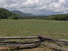
The Kituwa mound at Ferguson Field | |
  | |
| Location | U.S. Route 19 east of Bryson City, near Bryson City, North Carolina |
|---|---|
| Coordinates | 35°26′00″N 83°26′00″W / 35.43333°N 83.43333°WCoordinates: 35°26′00″N 83°26′00″W / 35.43333°N 83.43333°W |
| Area | 20 acres (8.1 ha) |
| NRHP Reference # | 73002239[1] |
| Added to NRHP | June 4, 1973 |
The Cherokee believe the ancient settlement of Kituwa (also spelled Kituwah, Keetoowah, Kittowa, and other similar variations) or giduwa (Cherokee:ᎩᏚᏩ), on the Tuckasegee River is their original settlement and is one of the "seven mother towns" in the Southeast. It is in Swain County, North Carolina, in the Great Smoky Mountains, near present-day Bryson City.
History
Kituwa is the site of an ancient earthwork mound, likely built by the Mississippian culture about 1000 CE. The Cherokee held the site sacred after settling here in a later time. Although the vegetation on the mound was burned repeatedly by the Cherokee for agriculture during the colonial period and plowed over for corn cultivation since Indian Removal in the 1830s, the mound is still visible.
During the period of European-American agricultural uses, the larger property was called Ferguson's Field. The mound is 170 feet (52 m) in diameter and five feet tall, although it was once taller. The Cherokee built a structure on top that housed their sacred flame, which was to be kept burning at all times.[2]
Moundbuilding by people of the various Woodland and Mississippian cultures was common throughout the Mississippi Basin and Ohio Valley. This included Tennessee to the west, Georgia to the southeast, Louisiana to the southwest, and Ohio, Indiana, Illinois, and Missouri to the northwest.
The Mississippian culture was documented as established in western North Carolina from 1000 CE.[3] Joara was a regional chiefdom in this culture. Additional Mississippian-culture sites have been identified extending southwest to the village later called Kituwa. The Mississippian culture peoples were part of vast trade networks that connected chiefdoms throughout the present-day eastern United States. Archaeologists believe the people of the smaller chiefdoms were eventually absorbed by the developing, larger Catawba and Cherokee tribes.
The inhabitants of Kituwah, the Ani-kitu-hwagi, influenced all of the towns along the Tuckasegee and Little Tennessee rivers. The people of this region became known as the Kituwah, also spelled Keetoowah. Because the Kituwah were responsible for the protection of the northern border from the Iroquois and the Algonquian peoples, the name became synonymous with the Cherokee among the people. The Cherokee who later occupied Kituwa were also part of extensive trade networks. The ancient site of the Mother Town Kituwa is visible in the general area of the Qualla Boundary, territory of the Cherokee.
During the Anglo-Cherokee War (1758–1761), British general James Grant used his army to destroy the ancient town. Its inhabitants migrated westward and settled in Mialoquo (Great Island Town) on the Little Tennessee River among the Overhill Cherokee. A later headman of this group was Dragging Canoe, son of Attakullakulla. When he led his warriors southwest to continue fighting the colonists of Upper East Tennessee, the entire population went with him, including those formerly of Kituwa.[4]
In the 1820s the Cherokees lost control of the Kituwa area when making land cessions to the United States.
20th century reclamation
It was not until 1996 that the people regained their "mother town", when the Eastern Band of the Cherokee purchased the site and 309 acres (1.25 km2). A 1997 archaeological survey of Kituwah found an early 18th-century village site covering 65 acres (260,000 m2). The density of artifacts indicated a long period of settlement.[5]
The Cherokee have debated how to use the land, with some people wanting to develop the property for community uses. Non-invasive archaeological surveys have discovered 15 burials, with the likelihood of up to 1000. A gradiometer was used to map the area. It also depicted the location of many hearth sites, including one at the center. This would likely have been associated with the sacred fire.[2]
These discoveries have led more of the Cherokee citizens to consider only such development as can be compatible with the sacred nature of the site. They are planning uses associated with community wellness and renewal. The Eastern Cherokee have sponsored two youth retreats at the site, which highlighted traditional ways of spiritual expression.[2]
Duke Energy controversy
Duke Energy attempted to build a $52 million substation near the Kituwah Cherokee ceremonial mounds. On February 4, 2010, the Cherokee Tribal Council passed a resolution stating,
It is this Tribe’s solemn responsibility and moral duty to care for and protect all of Kituwah from further desecration and degradation by human agency in order to preserve the integrity of the most important site for the origination and continuation of Cherokee culture, heritage, history and identity.[6]
On April 23, 2010, the North Carolina Utilities Commission denied Duke Energy's "Motion to Hold Complaint in Abeyance," and Duke was ordered to file an answer to the complaint on or before May 10, 2010. Duke agreed to halt the construction threatening Kituwah until the complaint was heard.[7]
Traditions
Cherokee oral traditions tell that all Cherokee migrated to Kituwa after the migration from the Great Lakes region of the United States and southern Canada as early as 4,000 years ago. Cultural and archaeological evidence support the people's accounts of their migration, but there is no consensus about when they arrived in the Southeast.[8]
The ancient Cherokee had a hereditary priesthood, called the Ah-ni-ku-ta-ni, a structure which may have been adopted from another tribe. According to research by the early 20th century ethnographer James Mooney, the Cherokee held the Ah-ni-ku-ta-ni "in awe" and "greatly feared them."[8] They were not the regular chiefs. These were known as the ugus (owls), known as "white" chiefs (sometimes identified as those who worked for peace or during times of peace), and the colona (ravens), or "red" chiefs (identified as those who led in times of war.)[8]
Some traditional Cherokee call themselves by the autonym of Ah-ni-ki-tu-wa-gi (spelled variously in local Oklahoma dialects as Ki-tu-wa or Gi-du-wa), Kituwa people. The meaning of the word Kituwa is known to contemporary Cherokee speakers. It is not widely reported because of its sacred nature.
Honoring the "mother town" was analogous to honoring Selu, the Cherokee Corn Mother (of the ancient Green Corn Ceremony and many other connections). Honoring mothers is a concept that has pervaded Cherokee culture. Well into the 20th century, the Cherokee had a kinship system of matrilineal descent, clan membership and family organization.[9]
In the Green Corn Ceremony, one of the two social dances performed is of ancient origin. It may have been practiced in the mother town of Kituwa. The dance is called ye-lu-le, which means "to the center". During it, all of the dancers shout ye-lu-le and move toward the fire in the center of the dance circle. This dance symbolizes the dispersal of the sacred fire given to the people, according to their ancient legends. During Green Corn ceremonies in traditional Cherokee society, the coals of new fire were carried to all the Cherokee. They were used to kindle the ceremonial fires in each town before any of the new corn could be eaten. The home fires in outlying Cherokee communities were extinguished before the ceremonies and relit from the coals of the fire kindled during the Green Corn Dances.[9]
References
- ↑ National Park Service (2010-07-09). "National Register Information System". National Register of Historic Places. National Park Service.
- 1 2 3 "Kituwah Mound, NC (Eastern Cherokee), 2004", The Pluralism Project, Harvard University, accessed 3 Mar 2009
- ↑ David G. Moore, Robin A. Beck, Jr., and Christopher B. Rodning, "Joara and Fort San Juan: culture contact at the edge of the world", Antiquity, Vol. 78, No. 229, Mar. 2004, accessed 26 Jun 2008
- ↑ Klink and Talman, The Journal of Major John Norton, p. 62
- ↑ "Proposed Development of Kituwah 'Mother Town' of the Cherokee, Debated", Cherokee Nations News, 20 Apr 2000
- ↑ "Tribe opposes Substation at Kituwah Site", Cherokee One Feather, SCOTT MCKIE B.P., accessed 9 Feb 2009
- ↑ "Citizens to Protect Kituwah Valley", Save Kituwah Valley
- 1 2 3 Mooney, James (2006) [1900]. Myths of the Cherokee and Sacred Formulas of the Cherokees. Kessinger Publishing. p. 393. ISBN 978-1-4286-4864-7.
- 1 2 Mooney, James (1995) [1900]. Myths of the Cherokee. Dover Publications. ISBN 0-486-28907-9.
Other sources
- Klink, Karl, and James Talman, ed. The Journal of Major John Norton. (Toronto: Champlain Society, 1970).

