| [3] |
Name on the Register[4] |
Image |
Date listed[5] |
Location |
City or town |
Description |
|---|
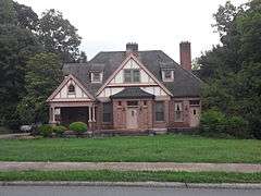
| 1 |
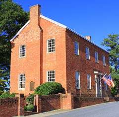
Caldwell-Cobb-Love House |
|
000000001986-02-06-0000February 6, 1986
(#86000159) |
218 E. Congress St.
35°28′08″N 81°15′13″W / 35.468889°N 81.253611°W / 35.468889; -81.253611 (Caldwell-Cobb-Love House) |
Lincolnton |
|
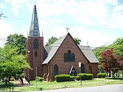
| 2 |
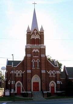
Emanuel United Church of Christ |
|
000000001994-12-14-0000December 14, 1994
(#94001453) |
329 E. Main St.
35°28′22″N 81°15′11″W / 35.472778°N 81.253056°W / 35.472778; -81.253056 (Emanuel United Church of Christ) |
Lincolnton |
Built in 1913, designed by Henry E. Bonitz
|
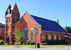
| 3 |
Emmanuel Lutheran Church |
|
000000001994-12-14-0000December 14, 1994
(#94001454) |
216 S. Aspen St.
35°28′11″N 81°15′26″W / 35.469722°N 81.257222°W / 35.469722; -81.257222 (Emmanuel Lutheran Church) |
Lincolnton |
|
| 4 |
Eureka Manufacturing Company Cotton Mill |
|
000000002013-12-18-0000December 18, 2013
(#13000934) |
414 E. Water St.
35°28′20″N 81°15′07″W / 35.472187°N 81.2519979°W / 35.472187; -81.2519979 (Eureka Manufacturing Company Cotton Mill) |
Lincolnton |
|
| 5 |
First Baptist Church |
|
000000001994-12-21-0000December 21, 1994
(#94001456) |
403 E. Main St.
35°28′24″N 81°15′09″W / 35.473333°N 81.2525°W / 35.473333; -81.2525 (First Baptist Church) |
Lincolnton |
|
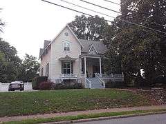
| 6 |
First Presbyterian Church |
|
000000001994-12-14-0000December 14, 1994
(#94001455) |
114 W. Main St.
35°28′16″N 81°15′31″W / 35.471111°N 81.258611°W / 35.471111; -81.258611 (First Presbyterian Church) |
Lincolnton |
|
| 7 |
First United Methodist Church |
|
000000001994-12-14-0000December 14, 1994
(#94001457) |
201 E. Main St.
35°28′19″N 81°15′20″W / 35.471944°N 81.255556°W / 35.471944; -81.255556 (First United Methodist Church) |
Lincolnton |
|
| 8 |
William A. Graham Jr. Farm |
Upload image |
000000001977-05-06-0000May 6, 1977
(#77001004) |
S of Denver on SR 1360
35°28′43″N 81°04′05″W / 35.478611°N 81.068056°W / 35.478611; -81.068056 (William A. Graham Jr. Farm) |
Kidville |
|
| 9 |
Ingleside |
|
000000001972-04-13-0000April 13, 1972
(#72000967) |
S of jct. of NC 73 and SR 1383
35°27′49″N 81°02′39″W / 35.463611°N 81.044167°W / 35.463611; -81.044167 (Ingleside) |
Iron Station |
|
| 10 |
Laboratory Historic District |
|
000000002003-12-10-0000December 10, 2003
(#03001273) |
Jct. of Laboratory Rd. and S. Fork Rd.
35°26′21″N 81°15′24″W / 35.439167°N 81.256667°W / 35.439167; -81.256667 (Laboratory Historic District) |
Laboratory |
|
| 11 |
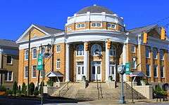
Lincoln County Courthouse |
|
000000001979-05-10-0000May 10, 1979
(#79001731) |
Courthouse Sq.
35°28′41″N 81°15′26″W / 35.478056°N 81.257222°W / 35.478056; -81.257222 (Lincoln County Courthouse) |
Lincolnton |
|
| 12 |
Lincolnton Commercial Historic District |
|
000000002005-12-16-0000December 16, 2005
(#05001419) |
Roughly bounded by Pine St., Poplar St., Church St. and W. Court Square
35°28′20″N 81°15′22″W / 35.472222°N 81.256111°W / 35.472222; -81.256111 (Lincolnton Commercial Historic District) |
Lincolnton |
|
| 13 |
Lincolnton Recreation Department Youth Center |
|
000000002009-12-30-0000December 30, 2009
(#09001178) |
119 E. Pine St.
35°28′22″N 81°15′27″W / 35.472822°N 81.257367°W / 35.472822; -81.257367 (Lincolnton Recreation Department Youth Center) |
Lincolnton |
|
| 14 |
Loretz House |
Upload image |
000000001972-03-16-0000March 16, 1972
(#72000969) |
NW of Lincolnton off SR 1204
35°30′48″N 81°15′53″W / 35.513333°N 81.264722°W / 35.513333; -81.264722 (Loretz House) |
Lincolnton |
|
| 15 |
Magnolia Grove |
Upload image |
000000001972-03-16-0000March 16, 1972
(#72000968) |
Jct. of SR 1309 and 1313
35°25′03″N 81°10′26″W / 35.4175°N 81.173889°W / 35.4175; -81.173889 (Magnolia Grove) |
Iron Station |
Boundaries increased on 000000001997-06-27-0000June 27, 1997
|
| 16 |
Methodist Church Cemetery |
Upload image |
000000001994-12-14-0000December 14, 1994
(#94001458) |
Jct. of S. Aspen and W. Congress Sts., W corner
35°28′04″N 81°15′23″W / 35.467778°N 81.256389°W / 35.467778; -81.256389 (Methodist Church Cemetery) |
Lincolnton |
|
| 17 |
Mount Welcome |
Upload image |
000000001991-09-13-0000September 13, 1991
(#91001413) |
Jct. of NC 1511 and NC 1412
35°25′45″N 81°03′13″W / 35.429167°N 81.053611°W / 35.429167; -81.053611 (Mount Welcome) |
Lowesville |
|
| 18 |
Old White Church Cemetery |
|
000000001994-12-14-0000December 14, 1994
(#94001459) |
Jct. of S. Aspen and Church Sts., E corner
35°28′11″N 81°15′21″W / 35.469722°N 81.255833°W / 35.469722; -81.255833 (Old White Church Cemetery) |
Lincolnton |
|
| 19 |
Pleasant Retreat Academy |
|
000000001975-05-29-0000May 29, 1975
(#75001277) |
129 E. Pine St.
35°28′20″N 81°15′22″W / 35.472222°N 81.256111°W / 35.472222; -81.256111 (Pleasant Retreat Academy) |
Lincolnton |
|
| 20 |
Reinhardt-Craig House, Kiln and Pottery Shop |
|
000000002008-01-09-0000January 9, 2008
(#07001376) |
3171 Cat Square Rd.
35°33′47″N 81°25′46″W / 35.563056°N 81.429444°W / 35.563056; -81.429444 (Reinhardt-Craig House, Kiln and Pottery Shop) |
Vale |
|
| 21 |
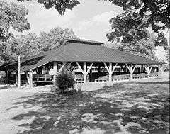
Rock Springs Camp Meeting Ground |
|
000000001972-09-22-0000September 22, 1972
(#72000970) |
SR 1373 off NC 16
35°32′25″N 81°01′40″W / 35.540278°N 81.027778°W / 35.540278; -81.027778 (Rock Springs Camp Meeting Ground) |
Denver |
|
| 22 |
Salem Union Church and Cemetery |
Upload image |
000000001995-10-04-0000October 4, 1995
(#95001118) |
Jct. of NC 1005 (Startown Rd.) and NC 1274 (Maiden-Salem Rd.), SE corner
35°32′51″N 81°15′54″W / 35.5475°N 81.265°W / 35.5475; -81.265 (Salem Union Church and Cemetery) |
Maiden |
|
| 23 |
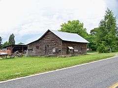
Andrew Seagle Farm |
Upload image |
000000001975-02-24-0000February 24, 1975
(#75001278) |
N of Reepsville off SR 1205
35°31′10″N 81°20′46″W / 35.519444°N 81.346111°W / 35.519444; -81.346111 (Andrew Seagle Farm) |
Reepsville |
|
| 24 |
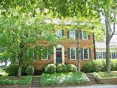
Shadow Lawn |
|
000000001972-03-24-0000March 24, 1972
(#72000971) |
301 W. Main St.
35°28′13″N 81°15′36″W / 35.470386°N 81.259881°W / 35.470386; -81.259881 (Shadow Lawn) |
Lincolnton |
|
| 25 |
South Aspen Street Historic District |
|
000000002003-01-15-0000January 15, 2003
(#02001713) |
500-1000 blks. S. Aspen St., 114-130 E. Rhodes St., and 624-636 W. Park Dr.
35°27′53″N 81°15′16″W / 35.464722°N 81.254444°W / 35.464722; -81.254444 (South Aspen Street Historic District) |
Lincolnton |
|
| 26 |
St. Luke's Church and Cemetery |
|
000000001992-01-14-0000January 14, 1992
(#91001914) |
303-321 N. Cedar St., 322 E. McBee St.
35°28′27″N 81°15′13″W / 35.474167°N 81.253611°W / 35.474167; -81.253611 (St. Luke's Church and Cemetery) |
Lincolnton |
|
| 27 |
Tucker's Grove Camp Meeting Ground |
Upload image |
000000001972-10-18-0000October 18, 1972
(#72000972) |
N of Iron Station off SR 1360
35°28′03″N 81°05′00″W / 35.4675°N 81.083333°W / 35.4675; -81.083333 (Tucker's Grove Camp Meeting Ground) |
Iron Station |
|
| 28 |
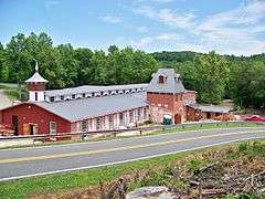
Vesuvius Furnace |
Upload image |
000000001974-08-13-0000August 13, 1974
(#74001359) |
On SR 1382, N of NC 73
35°29′31″N 81°05′00″W / 35.491944°N 81.083333°W / 35.491944; -81.083333 (Vesuvius Furnace) |
Catawba Springs |
|
| 29 |
West Main Street Historic District |
Upload image |
000000002003-01-15-0000January 15, 2003
(#02001716) |
200-300 W. Main St. and 114 N. High St.
35°28′13″N 81°15′37″W / 35.470278°N 81.260278°W / 35.470278; -81.260278 (West Main Street Historic District) |
Lincolnton |
|
| 30 |
Woodside |
Upload image |
000000001973-03-07-0000March 7, 1973
(#73001357) |
W of jct. of U.S. 182 and 27
35°27′15″N 81°16′42″W / 35.454167°N 81.278333°W / 35.454167; -81.278333 (Woodside) |
Lincolnton |
|

%2C_Lincolnton%2C_NC.jpg)

%2C_114_W._Main_Street%2C_Lincolnton%2C_NC.jpg)
.jpg)
.jpg)
%2C_Lincolnton%2C_NC.jpg)

%2C_Lincolnton%2C_NC.jpg)