| [3] |
Name on the Register[4] |
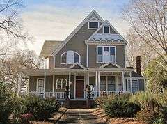
Image |
Date listed[5] |
Location |
City or town |
Description |
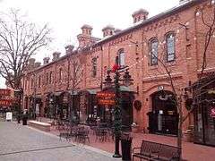
|---|
| 1 |
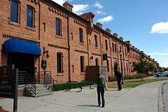
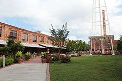
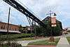
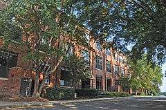
American Tobacco Company Manufacturing Plant |
|
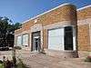
000000002000-09-29-0000September 29, 2000
(#00001163) |
Roughly bounded by W. Pettigrew St., Blackwell St., Willard St. and Carr St.
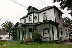
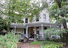
35°59′43″N 78°54′17″W / 35.995278°N 78.904722°W / 35.995278; -78.904722 (American Tobacco Company Manufacturing Plant) |
Durham |
|
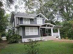
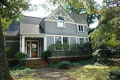
| 2 |
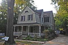
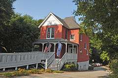
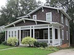
Bassett House |
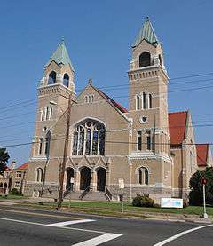
|
000000001979-11-29-0000November 29, 1979
(#79003330) |
1017 W. Trinity Ave.
36°00′20″N 78°54′38″W / 36.005556°N 78.910556°W / 36.005556; -78.910556 (Bassett House) |
Durham |
|
| 3 |
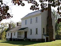
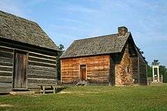
Bennett Place State Historic Site |
|
000000001970-02-26-0000February 26, 1970
(#70000452) |
4409 Bennett Memorial Rd.
36°01′45″N 78°58′32″W / 36.029167°N 78.975556°W / 36.029167; -78.975556 (Bennett Place State Historic Site) |
Durham |
Site of the largest surrender of Confederate troops during the Civil War, April 26, 1865[6]
|
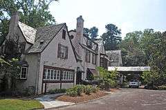
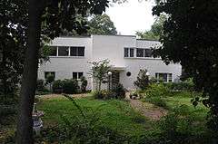
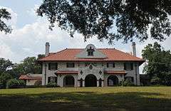
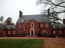
| 4 |
Mary Duke Biddle Estate |
|
000000002013-01-09-0000January 9, 2013
(#12001157) |
1044 & 1050 W. Forest Hills Blvd.
35°58′59″N 78°55′08″W / 35.98292°N 78.918854°W / 35.98292; -78.918854 (Mary Duke Biddle Estate) |
Durham |
|
| 5 |
Richard D. Blacknall House |
|
000000001990-03-01-0000March 1, 1990
(#90000350) |
300 Alexander Ave.
36°00′13″N 78°55′38″W / 36.003611°N 78.927222°W / 36.003611; -78.927222 (Richard D. Blacknall House) |
Durham |
|
| 6 |
Bright Leaf Historic District |
|
000000001999-12-30-0000December 30, 1999
(#99001619) |
Roughly bounded by W. Peabody St., Duke St., Minerva Ave., N&W RR, Corporation St., Ligget St., Morris St. and W. Loop
36°00′06″N 78°54′21″W / 36.001667°N 78.905833°W / 36.001667; -78.905833 (Bright Leaf Historic District) |
Durham |
|
| 7 |
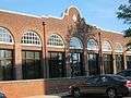
Bull Durham Tobacco Factory |
|
000000001974-09-10-0000September 10, 1974
(#74001346) |
201 W. Pettigrew St.
35°59′38″N 78°54′16″W / 35.993889°N 78.904444°W / 35.993889; -78.904444 (Bull Durham Tobacco Factory) |
Durham |
Also known as W. T. Blackwell and Company Tobacco Factory
|
| 8 |
Bullington Warehouse |
|
000000001982-08-30-0000August 30, 1982
(#82003448) |
500 N. Duke St.
36°00′10″N 78°54′22″W / 36.002778°N 78.906111°W / 36.002778; -78.906111 (Bullington Warehouse) |
Durham |
|
| 9 |
Burch Avenue Historic District |
|
000000002010-09-03-0000September 3, 2010
(#10000631) |
Roughly bounded by S. Buchanan Blvd., W. Chapel Hill St., Duke University Rd., Burch Ave., and Rome Ave.
35°59′53″N 78°55′03″W / 35.998056°N 78.9175°W / 35.998056; -78.9175 (Burch Avenue Historic District) |
Durham |
|
| 10 |
John C. and Binford Carr House |
Upload image |
000000002011-08-05-0000August 5, 2011
(#11000508) |
3400 Westover Rd.,
35°56′48″N 78°57′22″W / 35.946667°N 78.956111°W / 35.946667; -78.956111 (John C. and Binford Carr House) |
Durham |
|
| 11 |
City Garage Yard and Fire Drill Tower |
|
000000002000-05-03-0000May 3, 2000
(#00000394) |
501 Washington St.
36°00′38″N 78°54′37″W / 36.010556°N 78.910278°W / 36.010556; -78.910278 (City Garage Yard and Fire Drill Tower) |
Durham |
|
| 12 |
Clark and Sorrell Garage |
|
000000002000-08-16-0000August 16, 2000
(#00000991) |
323 Foster St.
36°00′03″N 78°54′47″W / 36.000833°N 78.913056°W / 36.000833; -78.913056 (Clark and Sorrell Garage) |
Durham |
|
| 13 |
Cleveland Street District |
|
000000001985-09-20-0000September 20, 1985
(#85002438) |
Roughly Cleveland St. between Seminary & Gray Aves. & Mallard St.
35°59′59″N 78°53′42″W / 35.999722°N 78.895°W / 35.999722; -78.895 (Cleveland Street District) |
Durham |
|
| 14 |
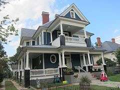
Cranford-Wannamaker House |
|
000000001979-11-29-0000November 29, 1979
(#79003331) |
1019 W. Trinity Ave.
36°00′22″N 78°54′38″W / 36.006111°N 78.910556°W / 36.006111; -78.910556 (Cranford-Wannamaker House) |
Durham |
|
| 15 |
Crowell House |
|
000000001979-11-29-0000November 29, 1979
(#79003332) |
504 Watts St.
36°00′22″N 78°54′41″W / 36.006111°N 78.911389°W / 36.006111; -78.911389 (Crowell House) |
Durham |
|
| 16 |
Dillard-Gamble Houses |
|
000000001979-01-19-0000January 19, 1979
(#79003333) |
1311 and 1307 N. Mangum St.
36°00′32″N 78°53′38″W / 36.008889°N 78.893889°W / 36.008889; -78.893889 (Dillard-Gamble Houses) |
Durham |
|
| 17 |
Downtown Durham Historic District |
|
000000001977-11-01-0000November 1, 1977
(#77000998) |
Roughly bounded by Peabody, Morgan, Seminary, Cleveland, Parrish, and Queen Sts.
35°59′42″N 78°54′01″W / 35.995°N 78.900278°W / 35.995; -78.900278 (Downtown Durham Historic District) |
Durham |
|
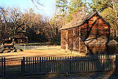
| 18 |
Duke Homestead and Tobacco Factory |
|
000000001966-11-13-0000November 13, 1966
(#66000590) |
0.5 miles (0.80 km) north of Durham on Guess Rd., east of SR 1025
36°02′06″N 78°55′16″W / 36.035°N 78.921111°W / 36.035; -78.921111 (Duke Homestead and Tobacco Factory) |
Durham |
|
| 19 |
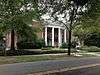
Duke Memorial United Methodist Church |
|
000000001985-08-11-0000August 11, 1985
(#85001781) |
504 W. Chapel Hill St.
35°59′51″N 78°54′34″W / 35.9975°N 78.909444°W / 35.9975; -78.909444 (Duke Memorial United Methodist Church) |
Durham |
|
| 20 |
Durham Cotton Mills Village Historic District |
Upload image |
000000001985-08-09-0000August 9, 1985
(#85001793) |
Roughly bounded by Byrd and Middle Sts., E. Frontage Rd. and Reservoir St.
35°58′36″N 78°52′56″W / 35.976667°N 78.882222°W / 35.976667; -78.882222 (Durham Cotton Mills Village Historic District) |
Durham |
|
| 21 |
Durham Hosiery Mill |
|
000000001978-11-14-0000November 14, 1978
(#78001944) |
Angier Ave.
35°59′19″N 78°53′34″W / 35.988611°N 78.892778°W / 35.988611; -78.892778 (Durham Hosiery Mill) |
Durham |
|
| 22 |
Durham Hosiery Mills Dye House |
|
000000002014-01-22-0000January 22, 2014
(#13001115) |
708-710 Gilbert St.
35°59′44″N 78°53′23″W / 35.995421°N 78.889659°W / 35.995421; -78.889659 (Durham Hosiery Mills Dye House) |
Durham |
|
| 23 |
Durham Hosiery Mills No. 2-Service Printing Company Building |
Upload image |
000000001985-11-27-0000November 27, 1985
(#85003055) |
504 E. Pettigrew St.
35°59′23″N 78°53′52″W / 35.989722°N 78.897778°W / 35.989722; -78.897778 (Durham Hosiery Mills No. 2-Service Printing Company Building) |
Durham |
Burned 1985/Deteriorated[7]
|
| 24 |
East Durham Historic District |
Upload image |
000000002004-12-23-0000December 23, 2004
(#04001393) |
Roughly bounded by Southern Railway right-of-way, N. Guthrie Ave. Holloway St., Hyde Park Ave, S. Plum St. and Vale St.
35°59′39″N 78°52′31″W / 35.994178°N 78.875378°W / 35.994178; -78.875378 (East Durham Historic District) |
Durham |
|
| 25 |
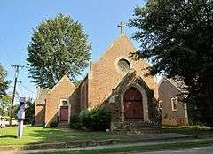
Emmanuel AME Church |
|
000000001985-08-09-0000August 9, 1985
(#85001775) |
710 Kent St.
35°59′40″N 78°55′08″W / 35.994444°N 78.918889°W / 35.994444; -78.918889 (Emmanuel AME Church) |
Durham |
|
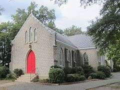
| 26 |
Ephphatha Church |
|
000000001985-08-09-0000August 9, 1985
(#85001778) |
220 W. Geer St.
36°00′20″N 78°53′53″W / 36.005556°N 78.898056°W / 36.005556; -78.898056 (Ephphatha Church) |
Durham |
|
| 27 |
Erwin Cotton Mills Company Mill No. 1 Headquarters Building |
|
000000001984-11-20-0000November 20, 1984
(#84002724) |
W. Main and 9th Sts.
36°00′27″N 78°55′24″W / 36.0075°N 78.923333°W / 36.0075; -78.923333 (Erwin Cotton Mills Company Mill No. 1 Headquarters Building) |
Durham |
|
| 28 |
Fairntosh Plantation |
Upload image |
000000001973-04-03-0000April 3, 1973
(#73001337) |
Near junction of SR 1004 and 1632
36°05′56″N 78°49′42″W / 36.098889°N 78.828333°W / 36.098889; -78.828333 (Fairntosh Plantation) |
Durham |
|
| 29 |
Wiley and Elizabeth Forbus House |
Upload image |
000000002005-04-28-0000April 28, 2005
(#05000348) |
3307 Devon Rd.
35°57′07″N 78°57′11″W / 35.951875°N 78.952969°W / 35.951875; -78.952969 (Wiley and Elizabeth Forbus House) |
Durham |
|
| 30 |
Forest Hills Historic District |
Upload image |
000000002005-12-28-0000December 28, 2005
(#05001476) |
Roughly bounded by Kent St., Bivins St., Wells St., American Tobacco Trail, Forestwood Dr. and Beverly Dr.
35°58′55″N 78°54′53″W / 35.981944°N 78.914722°W / 35.981944; -78.914722 (Forest Hills Historic District) |
Durham |
|
| 31 |
Foster and West Geer Streets Historic District |
|
000000002013-04-23-0000April 23, 2013
(#13000204) |
Bounded by W. Corporation, Madison & Washington Sts., Rigsbee Ave., N&SRR tracks, 724 & 733 Foster St.
36°00′14″N 78°54′05″W / 36.0037727°N 78.9014059°W / 36.0037727; -78.9014059 (Foster and West Geer Streets Historic District) |
Durham |
|
| 32 |
Golden Belt Historic District |
Upload image |
000000001985-08-09-0000August 9, 1985
(#85001791) |
Roughly bounded by Norfolk & Western Railroad, Taylor, Holman Sts., Morning Glory Ave., and Main St.; also 1000-1004 E. Main St.
35°59′26″N 78°53′20″W / 35.990556°N 78.888889°W / 35.990556; -78.888889 (Golden Belt Historic District) |
Durham |
Second set of addresses represents a boundary increase of 000000001996-07-30-0000July 30, 1996
|
| 33 |
Greystone |
|
000000001982-06-01-0000June 1, 1982
(#82003449) |
618 Morehead Ave.
35°59′32″N 78°54′32″W / 35.992222°N 78.908889°W / 35.992222; -78.908889 (Greystone) |
Durham |
|
| 34 |
Hampton-Ellis Farm |
Upload image |
000000002011-12-22-0000December 22, 2011
(#11000955) |
3305 Pat Tilley Rd.
36°10′11″N 78°50′01″W / 36.169622°N 78.833533°W / 36.169622; -78.833533 (Hampton-Ellis Farm) |
Bahama vicinity |
|
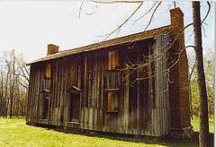
| 35 |
Hardscrabble |
Upload image |
000000001972-01-20-0000January 20, 1972
(#72000960) |
North side of SR 1002, 1.2 miles (1.9 km) west of junction with SR 1003
36°08′01″N 78°57′36″W / 36.133611°N 78.96°W / 36.133611; -78.96 (Hardscrabble) |
Bahama |
|
| 36 |
John Sprunt Hill House |
|
000000001978-01-30-0000January 30, 1978
(#78001945) |
900 S. Duke St.
35°59′18″N 78°54′36″W / 35.988333°N 78.91°W / 35.988333; -78.91 (John Sprunt Hill House) |
Durham |
|
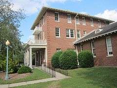
| 37 |
Hillside Park High School |
Upload image |
000000002013-12-30-0000December 30, 2013
(#13001026) |
200 E. Ulmstead St.
35°58′56″N 78°54′09″W / 35.982127°N 78.902595°W / 35.982127; -78.902595 (Hillside Park High School) |
Durham |
Part of the Durham MRA
|
| 38 |
Holloway Street District |
|
000000001985-09-20-0000September 20, 1985
(#85002437) |
Roughly bounded by Holloway, Railroad, and Liberty Sts., Peachtree Pl., and Dillard St.; also roughly bounded by Holloway, Elizabeth, Primitive, and Queen Sts., and Mallard Ave.
35°59′43″N 78°53′30″W / 35.995278°N 78.891667°W / 35.995278; -78.891667 (Holloway Street District) |
Durham |
Second set of boundaries represents a boundary increase of 000000002009-04-30-0000April 30, 2009
|
| 39 |
Kinchen Holloway House |
Upload image |
000000002008-08-29-0000August 29, 2008
(#08000814) |
4418 Guess Rd.
36°04′26″N 78°55′59″W / 36.073761°N 78.93315°W / 36.073761; -78.93315 (Kinchen Holloway House) |
Durham |
|
| 40 |
Hope Valley Historic District |
Upload image |
000000002009-12-11-0000December 11, 2009
(#09001105) |
Avon Rd., Chelsea Circle, Cornwall Rd., Devon Rd. Exeter Way, Littlewoods Ln., Norwich Way, Stratford Rd.
35°56′56″N 78°56′52″W / 35.948767°N 78.947894°W / 35.948767; -78.947894 (Hope Valley Historic District) |
Durham |
|
| 41 |
Horton Grove Complex |
|
000000001978-03-17-0000March 17, 1978
(#78001946) |
North of Durham on SR 1626
36°07′35″N 78°50′22″W / 36.126389°N 78.839444°W / 36.126389; -78.839444 (Horton Grove Complex) |
Durham |
|
| 42 |
Lakewood Park Historic District |
Upload image |
000000002003-05-01-0000May 1, 2003
(#03000340) |
1601-1907 W. Lakewood Ave., 2001-2112 Chapel Hill Rd., 1406-1601 James St. and 1809-1819 Bivins St.
35°59′14″N 78°55′33″W / 35.987222°N 78.925833°W / 35.987222; -78.925833 (Lakewood Park Historic District) |
Durham |
|
| 43 |
Leigh Farm |
Upload image |
000000001975-09-05-0000September 5, 1975
(#75001257) |
East of Chapel Hill off NC 54
35°55′19″N 78°58′58″W / 35.921944°N 78.982778°W / 35.921944; -78.982778 (Leigh Farm) |
Chapel Hill |
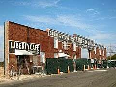
|
| 44 |
Liberty Warehouse Nos. 1 and 2 |
|
000000002008-08-06-0000August 6, 2008
(#08000774) |
611-613 Rigsbee Ave.
36°00′05″N 78°54′00″W / 36.0013°N 78.899969°W / 36.0013; -78.899969 (Liberty Warehouse Nos. 1 and 2) |
Durham |
|
| 45 |
Little Creek Site (31 DH 351) |
|
000000001985-01-11-0000January 11, 1985
(#85000118) |
Address Restricted
|
Chapel Hill |
|
| 46 |
Bartlett Mangum House |
Upload image |
000000001989-05-25-0000May 25, 1989
(#89000446) |
2701 Chapel Hill Rd.
35°58′37″N 78°56′10″W / 35.976944°N 78.936111°W / 35.976944; -78.936111 (Bartlett Mangum House) |
Durham |
|
| 47 |
Meadowmont |
|
000000001985-07-11-0000July 11, 1985
(#85001554) |
Off NC 54
35°54′40″N 79°00′19″W / 35.911111°N 79.005278°W / 35.911111; -79.005278 (Meadowmont) |
Chapel Hill |
|
| 48 |
Morehead Hill Historic District |
Upload image |
000000001985-08-09-0000August 9, 1985
(#85001792) |
Roughly bounded by Jackson St., East-West Expressway, S. Duke St., Lakewood Ave., Shephard St., and Arnette Ave.; also portions of Arnette, Vickers, Yancey, Parker, and Wells Sts.
35°59′23″N 78°54′46″W / 35.989722°N 78.912778°W / 35.989722; -78.912778 (Morehead Hill Historic District) |
Durham |
Second set of boundaries represents a boundary increase of 000000002004-06-02-0000June 2, 2004
|
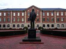
| 49 |
North Carolina Central University |
|
000000001986-03-28-0000March 28, 1986
(#86000676) |
Bounded by Lawson St., Alston Ave., Nelson, and Fayette Sts.
35°58′23″N 78°53′47″W / 35.972983°N 78.896289°W / 35.972983; -78.896289 (North Carolina Central University) |
Durham |
|
| 50 |
North Carolina Mutual Life Insurance Company Building |
|
000000001975-05-15-0000May 15, 1975
(#75001258) |
114-116 W. Parrish St.
35°59′43″N 78°54′02″W / 35.995278°N 78.900556°W / 35.995278; -78.900556 (North Carolina Mutual Life Insurance Company Building) |
Durham |
|
| 51 |
North Durham County Prison Camp (Former) |
|
000000001998-12-31-0000December 31, 1998
(#98001573) |
2410 Broad St.
36°01′57″N 78°54′39″W / 36.032589°N 78.910831°W / 36.032589; -78.910831 (North Durham County Prison Camp (Former)) |
Durham |
|
| 52 |
North Durham-Duke Park District |
|
000000001985-06-20-0000June 20, 1985
(#85001338) |
Roughly bounded by Glendale Ave., W. Knox St., Roxboro Rd., Trinity Ave., Magnum & Broadway Sts.
36°00′22″N 78°53′38″W / 36.006111°N 78.893889°W / 36.006111; -78.893889 (North Durham-Duke Park District) |
Durham |
|
| 53 |
William Thomas O'Brien House |
|
000000001985-08-09-0000August 9, 1985
(#85001777) |
820 Wilkerson Ave.
36°00′06″N 78°54′55″W / 36.001667°N 78.915278°W / 36.001667; -78.915278 (William Thomas O'Brien House) |
Durham |
|
| 54 |
Pearl Mill Village Historic District |
|
000000001985-08-09-0000August 9, 1985
(#85001782) |
900 block of Washington and Orient Sts. between Trinity and Dacien Aves.
36°00′19″N 78°54′08″W / 36.005278°N 78.902222°W / 36.005278; -78.902222 (Pearl Mill Village Historic District) |
Durham |
|
| 55 |
Pegram House |
|
000000001979-11-29-0000November 29, 1979
(#79003334) |
1019 Minerva Ave.
36°00′20″N 78°54′38″W / 36.005556°N 78.910556°W / 36.005556; -78.910556 (Pegram House) |
Durham |
|
| 56 |
George Poland House |
Upload image |
000000002004-12-04-0000December 4, 2004
(#04001287) |
502 John Jones Rd.
36°08′43″N 78°53′41″W / 36.145303°N 78.894694°W / 36.145303; -78.894694 (George Poland House) |
Bahama |
|
| 57 |
Powe House |
Upload image |
000000001985-08-09-0000August 9, 1985
(#85001780) |
1503 W. Pettigrew St.
36°00′18″N 78°55′11″W / 36.005°N 78.919722°W / 36.005; -78.919722 (Powe House) |
Durham |
|
| 58 |
Russell School |
|
000000002009-08-05-0000August 5, 2009
(#09000601) |
2001 St. Mary's Rd. (south side SR 1002 .1 miles (0.16 km) west of junction with SR 1003)
36°07′24″N 78°56′45″W / 36.123342°N 78.945797°W / 36.123342; -78.945797 (Russell School) |
Durham |
|
| 59 |
St. Joseph's African Methodist Episcopal Church |
|
000000001976-08-11-0000August 11, 1976
(#76001319) |
Fayetteville St. and Durham Expwy.
35°59′11″N 78°53′53″W / 35.986389°N 78.898056°W / 35.986389; -78.898056 (St. Joseph's African Methodist Episcopal Church) |
Durham |
|
| 60 |
Scarborough House |
Upload image |
000000001985-08-09-0000August 9, 1985
(#85001779) |
1406 Fayetteville St.
35°58′41″N 78°54′02″W / 35.978056°N 78.900556°W / 35.978056; -78.900556 (Scarborough House) |
Durham |
|
| 61 |
Scott and Roberts Dry Cleaning Plant, Office, and Store |
|
000000002012-06-20-0000June 20, 2012
(#12000345) |
733 Foster St.
36°00′18″N 78°54′06″W / 36.004934°N 78.901718°W / 36.004934; -78.901718 (Scott and Roberts Dry Cleaning Plant, Office, and Store) |
Durham |
|
| 62 |
Smith Warehouse |
|
000000001985-09-16-0000September 16, 1985
(#85002429) |
100 N. Buchanan Blvd.
36°00′05″N 78°54′57″W / 36.001389°N 78.915833°W / 36.001389; -78.915833 (Smith Warehouse) |
Durham |
|
| 63 |
Stagville |
|
000000001973-05-25-0000May 25, 1973
(#73001338) |
5828 Old Oxford Highway
36°06′03″N 78°50′19″W / 36.100833°N 78.838611°W / 36.100833; -78.838611 (Stagville) |
Durham |
|
| 64 |
Stokesdale Historic District |
Upload image |
000000002010-12-28-0000December 28, 2010
(#10001093) |
Roughly bounded by Fayetteville St., Umstead St., Lawson St., Moline St., Concord St., and Dunstan St.
35°58′48″N 78°54′04″W / 35.98°N 78.901111°W / 35.98; -78.901111 (Stokesdale Historic District) |
Durham |
|
| 65 |
Marcus Tilley House |
Upload image |
000000002000-01-14-0000January 14, 2000
(#99001684) |
7616 Jock Rd.
36°09′20″N 78°50′26″W / 36.155556°N 78.840556°W / 36.155556; -78.840556 (Marcus Tilley House) |
Bahama |
|
| 66 |
Trinity Historic District |
|
000000001986-03-26-0000March 26, 1986
(#86000672) |
Roughly bounded by Green, Duke, Morgan, and W. Main Sts., Markham Ave., and Clarendon St.; also roughly bounded by the original Trinity Historic District, N. Buchanan Boulevard, W. Club Boulevard, Woodland Dr., and N. Duke St.; also 209-215 N. Gregson St.
36°00′22″N 78°54′43″W / 36.006111°N 78.911944°W / 36.006111; -78.911944 (Trinity Historic District) |
Durham |
Second and third sets of boundaries represent boundary increases of 000000002004-06-04-0000June 4, 2004 and 000000002008-01-09-0000January 9, 2008 respectively
|
| 67 |
Adolphus W. Umstead House |
Upload image |
000000001989-09-14-0000September 14, 1989
(#89001418) |
NC 1607, 0.5 miles (0.80 km) north of NC 1611
36°11′07″N 78°51′16″W / 36.185278°N 78.854444°W / 36.185278; -78.854444 (Adolphus W. Umstead House) |
Bahama |
|
| 68 |
D.C. Umstead Store and House |
Upload image |
000000002014-12-02-0000December 2, 2014
(#14000983) |
3500 Hall Rd.
36°11′04″N 78°50′41″W / 36.1845°N 78.8446°W / 36.1845; -78.8446 (D.C. Umstead Store and House) |
Bahama vicinity |
|
| 69 |
Venable Tobacco Company Prizery and Receiving Room |
Upload image |
000000002003-08-21-0000August 21, 2003
(#03000804) |
302-304 East Pettigrew
35°59′35″N 78°53′58″W / 35.993056°N 78.899444°W / 35.993056; -78.899444 (Venable Tobacco Company Prizery and Receiving Room) |
Durham |
|
| 70 |
Venable Tobacco Company Warehouse |
Upload image |
000000001985-08-09-0000August 9, 1985
(#85001847) |
302-304 E. Pettigrew St.
35°59′31″N 78°54′00″W / 35.991944°N 78.9°W / 35.991944; -78.9 (Venable Tobacco Company Warehouse) |
Durham |
|
| 71 |
Watts and Yuille Warehouses |
|
000000001984-04-05-0000April 5, 1984
(#84002259) |
905 W. Main St.
36°00′01″N 78°54′37″W / 36.000278°N 78.910278°W / 36.000278; -78.910278 (Watts and Yuille Warehouses) |
Durham |
|
| 72 |
Watts Hospital |
|
000000001980-04-02-0000April 2, 1980
(#80002824) |
Broad St. and Club Blvd.
36°01′09″N 78°55′15″W / 36.019167°N 78.920833°W / 36.019167; -78.920833 (Watts Hospital) |
Durham |
|
| 73 |
Watts-Hillandale Historic District |
|
000000002001-04-25-0000April 25, 2001
(#01000427) |
Roughly bounded by Durham Waterworks, Wilson St., Sprunt Ave., Broad St., Englewood Ave., and Hillsborough Rd.
36°01′14″N 78°55′45″W / 36.020556°N 78.929167°W / 36.020556; -78.929167 (Watts-Hillandale Historic District) |
Durham |
|
| 74 |
West Durham Historic District |
|
000000001986-03-26-0000March 26, 1986
(#86000680) |
Roughly bounded by Knox, Ninth, W. Main Sts., and Rutherford St. and Carolina Ave.
36°00′41″N 78°55′28″W / 36.011389°N 78.924444°W / 36.011389; -78.924444 (West Durham Historic District) |
Durham |
|
| 75 |
West Point on the Eno |
|
000000001985-08-09-0000August 9, 1985
(#85001776) |
5101 N Roxboro St.
36°04′11″N 78°54′31″W / 36.069722°N 78.908611°W / 36.069722; -78.908611 (West Point on the Eno) |
Durham |
|
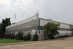
| 76 |
Wright's Automatic Machinery Company |
|
000000002012-12-26-0000December 26, 2012
(#12001088) |
915 Holloway St.
35°59′42″N 78°53′04″W / 35.995134°N 78.884348°W / 35.995134; -78.884348 (Wright's Automatic Machinery Company) |
Durham |
|
.jpg)

.jpg)
_Emmanuel_AME_Church%2C_view_2.JPG)


_04.jpg)