| [3] |
Name on the Register[4] |
Image |
Date listed[5] |
Location |
City or town |
Description |
|---|
| 1 |
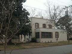
Bear Grass Primitive Baptist Church |
Upload image |
000000002005-04-28-0000April 28, 2005
(#05000352) |
NW side NC 1001, 0.1 miles N of jct with NC 1106
35°46′03″N 77°07′42″W / 35.7675°N 77.128333°W / 35.7675; -77.128333 (Bear Grass Primitive Baptist Church) |
Bear Grass |
|
| 2 |
Bear Grass School |
Upload image |
000000002005-06-01-0000June 1, 2005
(#05000515) |
6344 E. Bear Grass Rd.
35°46′05″N 77°07′38″W / 35.768056°N 77.127222°W / 35.768056; -77.127222 (Bear Grass School) |
Bear Grass |
|
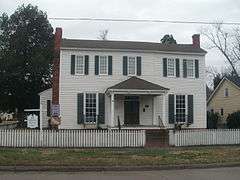
| 3 |
Asa Biggs House and Site |
|
000000001979-10-10-0000October 10, 1979
(#79003335) |
100 E. Church St.
35°51′22″N 77°03′24″W / 35.856111°N 77.056667°W / 35.856111; -77.056667 (Asa Biggs House and Site) |
Williamston |
|
| 4 |
Burras House |
Upload image |
000000001978-03-30-0000March 30, 1978
(#78001962) |
On U.S. 64
35°48′33″N 76°54′05″W / 35.809167°N 76.901389°W / 35.809167; -76.901389 (Burras House) |
Jamesville |
|
| 5 |
Conoho Creek Historic District |
Upload image |
000000001998-03-12-0000March 12, 1998
(#98000230) |
Roughly bounded by Conoho Cr., Salsbury Mill Branch, and 0.5 miles S of NC 142
35°54′31″N 77°14′21″W / 35.908611°N 77.239167°W / 35.908611; -77.239167 (Conoho Creek Historic District) |
Hassell |
|
| 6 |
Darden Hotel |
Upload image |
000000001975-12-30-0000December 30, 1975
(#75001280) |
Main St.
35°56′33″N 77°12′32″W / 35.9425°N 77.208889°W / 35.9425; -77.208889 (Darden Hotel) |
Hamilton |
|
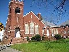
| 7 |
Everetts Christian Church |
Upload image |
000000002005-04-28-0000April 28, 2005
(#05000351) |
109 S. Broad St.
35°49′59″N 77°10′14″W / 35.833056°N 77.170556°W / 35.833056; -77.170556 (Everetts Christian Church) |
Everetts |
|
| 8 |
Everetts Historic District |
Upload image |
000000002014-12-02-0000December 2, 2014
(#14000988) |
Roughly bounded by Barnhill, Peel, Main, Ayers & James Sts.
35°50′05″N 77°10′15″W / 35.8347°N 77.1709°W / 35.8347; -77.1709 (Everetts Historic District) |
Everetts |
|
| 9 |
First Christian Church |
|
000000002005-04-28-0000April 28, 2005
(#05000353) |
126 S. Main St.
35°49′22″N 77°15′11″W / 35.822778°N 77.253056°W / 35.822778; -77.253056 (First Christian Church) |
Robersonville |
|
| 10 |
Fort Branch Site |
Upload image |
000000001973-06-18-0000June 18, 1973
(#73001358) |
SE of Hamilton on SR 1416
35°55′39″N 77°10′19″W / 35.9275°N 77.171944°W / 35.9275; -77.171944 (Fort Branch Site) |
Hamilton |
|
| 11 |
W. W. Griffin Farm |
Upload image |
000000002001-10-20-0000October 20, 2001
(#01001134) |
1871 Wendell Griffin Rd.
35°49′45″N 76°57′29″W / 35.829167°N 76.958056°W / 35.829167; -76.958056 (W. W. Griffin Farm) |
Williamston |
|
| 12 |
Hamilton Historic District |
Upload image |
000000001980-06-03-0000June 3, 1980
(#80002884) |
NC 125
35°56′41″N 77°12′31″W / 35.944722°N 77.208611°W / 35.944722; -77.208611 (Hamilton Historic District) |
Hamilton |
|
| 13 |
Hickory Hill |
Upload image |
000000001984-12-20-0000December 20, 1984
(#84000546) |
NC 903
35°56′59″N 77°13′14″W / 35.949722°N 77.220556°W / 35.949722; -77.220556 (Hickory Hill) |
Hamilton |
|
| 14 |
Jamesville Primitive Baptist Church and Cemetery |
Upload image |
000000001984-12-20-0000December 20, 1984
(#84000556) |
E side of NC 171
35°48′35″N 76°53′51″W / 35.809722°N 76.8975°W / 35.809722; -76.8975 (Jamesville Primitive Baptist Church and Cemetery) |
Jamesville |
|
| 15 |
Jesse Fuller Jones House |
Upload image |
000000001982-04-29-0000April 29, 1982
(#82003485) |
Off SR 1409
35°53′02″N 77°11′08″W / 35.883889°N 77.185556°W / 35.883889; -77.185556 (Jesse Fuller Jones House) |
Spring Green |
|
| 16 |
W. J. Little House |
Upload image |
000000001985-09-19-0000September 19, 1985
(#85002420) |
109 N. Main St.
35°49′30″N 77°15′16″W / 35.825°N 77.254444°W / 35.825; -77.254444 (W. J. Little House) |
Robersonville |
|
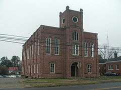
| 17 |
Martin County Courthouse |
|
000000001979-05-10-0000May 10, 1979
(#79001733) |
Main St.
35°51′54″N 77°03′10″W / 35.865°N 77.052778°W / 35.865; -77.052778 (Martin County Courthouse) |
Williamston |
|
| 18 |
Oak City Christian Church |
Upload image |
000000002005-04-28-0000April 28, 2005
(#05000354) |
310 W. Commerce St.
35°57′37″N 77°18′53″W / 35.960278°N 77.314722°W / 35.960278; -77.314722 (Oak City Christian Church) |
Oak City |
|
| 19 |
Roberson-Everett-Roebuck House |
Upload image |
000000002010-08-30-0000August 30, 2010
(#10000602) |
105 S. Outerbridge St.
35°49′25″N 77°15′26″W / 35.823611°N 77.257222°W / 35.823611; -77.257222 (Roberson-Everett-Roebuck House) |
Robersonville |
|
| 20 |
Robersonville Primitive Baptist Church |
|
000000002005-04-20-0000April 20, 2005
(#05000322) |
107 N. Outterbridge St.
35°49′28″N 77°15′29″W / 35.824444°N 77.258056°W / 35.824444; -77.258056 (Robersonville Primitive Baptist Church) |
Robersonville |
Now known as St. James Place Museum
|
| 21 |
Sherrod Farm |
Upload image |
000000001984-12-20-0000December 20, 1984
(#84000552) |
W side of NC 125/903
35°55′31″N 77°12′30″W / 35.925278°N 77.208333°W / 35.925278; -77.208333 (Sherrod Farm) |
Hamilton |
|
| 22 |
Skewarkey Primitive Baptist Church |
|
000000002005-04-28-0000April 28, 2005
(#05000355) |
W side of US 17, 0.04 miles S. of jct. with US 64
35°50′25″N 77°03′54″W / 35.840278°N 77.065°W / 35.840278; -77.065 (Skewarkey Primitive Baptist Church) |
Williamston |
|
| 23 |
Smithwick's Creek Primitive Baptist Church |
Upload image |
000000002005-04-20-0000April 20, 2005
(#05000324) |
Jct. of NC 1106 at NC 1516
35°43′28″N 77°02′16″W / 35.724444°N 77.037778°W / 35.724444; -77.037778 (Smithwick's Creek Primitive Baptist Church) |
Farm Life |
|
| 24 |
Spring Green Primitive Baptist Church |
Upload image |
000000002005-04-20-0000April 20, 2005
(#05000323) |
Jct. of NC 1409 and NC 903
35°53′40″N 77°11′41″W / 35.894444°N 77.194722°W / 35.894444; -77.194722 (Spring Green Primitive Baptist Church) |
Hamilton |
|
| 25 |
Sunny Side Inn |
|
000000001995-11-29-0000November 29, 1995
(#95001396) |
1102 Washington St.
35°50′32″N 77°03′47″W / 35.842222°N 77.063056°W / 35.842222; -77.063056 (Sunny Side Inn) |
Williamston |
|
| 26 |
Williamston Colored School |
|
000000002014-07-25-0000July 25, 2014
(#14000445) |
705 Washington St.
35°50′45″N 77°03′38″W / 35.8457°N 77.0606°W / 35.8457; -77.0606 (Williamston Colored School) |
Williamston |
|
| 27 |
Williamston Commercial Historic District |
|
000000001995-03-09-0000March 9, 1995
(#95000174) |
Roughly, areas surrounding the 100 blocks of E. Main, W. Main and S. Smithwick Sts. and the 200 block of Washington St.
35°51′17″N 77°03′21″W / 35.854722°N 77.055833°W / 35.854722; -77.055833 (Williamston Commercial Historic District) |
Williamston |
|
| 28 |
Williamston Historic District |
|
000000002001-10-12-0000October 12, 2001
(#01001095) |
Roughly bounded by Franklin, Harrell, Williams, South Haughton, North Railroad, Roberson, and White Sts.
35°51′14″N 77°03′22″W / 35.853889°N 77.056111°W / 35.853889; -77.056111 (Williamston Historic District) |
Williamston |
|