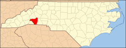
| [3] |
Name on the Register[4] |
Image |
Date listed[5] |
Location |
City or town |
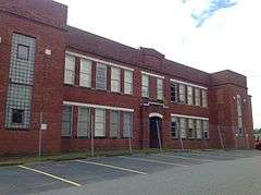
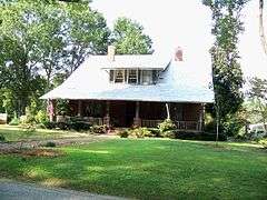
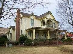
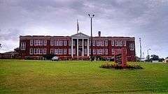
Description |
|---|
| 1 |
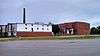
Alexander Manufacturing Company Mill Village Historic District |
|
000000002008-05-15-0000May 15, 2008
(#08000413) |
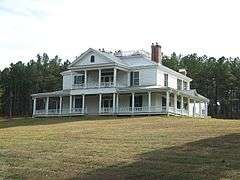
Roughly bounded by Victory and Wilson Drs. and Allen and S. Broadway Sts.
35°18′37″N 81°51′22″W / 35.31017°N 81.856064°W / 35.31017; -81.856064 (Alexander Manufacturing Company Mill Village Historic District) |
Forest City |
|
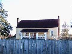
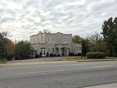
| 2 |
Bechtler Mint Site |
Upload image |
000000001997-04-14-0000April 14, 1997
(#97000316) |
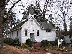
342 Gilboa Church Rd.[6]
35°24′49″N 81°58′16″W / 35.4135616°N 81.971046°W / 35.4135616; -81.971046 (Bechtler Mint Site) |
Rutherfordton |
|
| 3 |
Bostic Charge Parsonage |
|
000000002012-08-28-0000August 28, 2012
(#12000580) |
149 Old Sunshine Rd.
35°21′54″N 81°50′03″W / 35.365125°N 81.834167°W / 35.365125; -81.834167 (Bostic Charge Parsonage) |
Bostic |
|
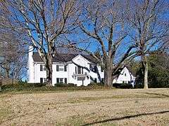
| 4 |
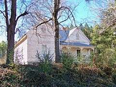
Carrier Houses |
|
000000001992-06-19-0000June 19, 1992
(#92000681) |
415 and 423 N. Main St.
35°22′11″N 81°57′25″W / 35.369722°N 81.956944°W / 35.369722; -81.956944 (Carrier Houses) |
Rutherfordton |
|
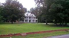
| 5 |
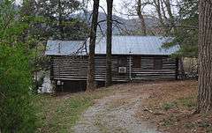
Carson-Andrews Mill and Ben F.W. Andrews House |
|
000000002008-06-04-0000June 4, 2008
(#08000495) |
Both sides of NC 1007, east, south, and west of the junction with NC 1796
35°24′37″N 81°50′13″W / 35.410297°N 81.836886°W / 35.410297; -81.836886 (Carson-Andrews Mill and Ben F.W. Andrews House) |
Washburn |
|
| 6 |
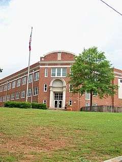
Cliffside Public School |
|
000000001998-01-26-0000January 26, 1998
(#97001667) |
1 N. Main St.
35°14′48″N 81°46′10″W / 35.246667°N 81.769444°W / 35.246667; -81.769444 (Cliffside Public School) |
Cliffside |
|
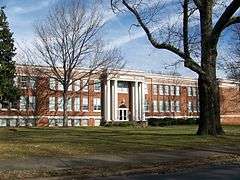
| 7 |
Cool Springs High School |
|
000000001999-07-08-0000July 8, 1999
(#99000813) |
382 W. Main St.
35°20′19″N 81°51′58″W / 35.338611°N 81.866111°W / 35.338611; -81.866111 (Cool Springs High School) |
Forest City |
|
| 8 |
East Main Street Historic District |
Upload image |
000000002005-12-23-0000December 23, 2005
(#05001450) |
Roughly along parts of Arlington St., Carolina Ave., N. Magnolia St., S. Magnolia St., E. Main St., and McBrayer Court
35°19′56″N 81°51′16″W / 35.332222°N 81.854444°W / 35.332222; -81.854444 (East Main Street Historic District) |
Forest City |
|
| 9 |
Forest City Baptist Church |
|
000000001989-09-14-0000September 14, 1989
(#89001417) |
301 W. Main St.
35°20′03″N 81°52′09″W / 35.334167°N 81.869167°W / 35.334167; -81.869167 (Forest City Baptist Church) |
Forest City |
|
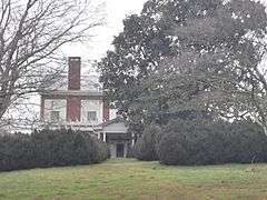
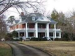
| 10 |
Fox Haven Plantation |
|
000000001972-09-14-0000September 14, 1972
(#72000996) |
Southwest of Rutherfordton off SR 1157
35°20′53″N 82°03′13″W / 35.348056°N 82.053611°W / 35.348056; -82.053611 (Fox Haven Plantation) |
Rutherfordton |
|
| 11 |
Gilbert Town Historic District |
|
000000002006-08-23-0000August 23, 2006
(#06000726) |
Along sections of Rock Rd. (NC 1520) and Old Gilbert Town Rd. (NC 1539)
35°24′25″N 81°56′37″W / 35.406944°N 81.943611°W / 35.406944; -81.943611 (Gilbert Town Historic District) |
Rutherfordton |
|
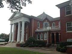
| 12 |
Henrietta-Caroleen High School |
|
000000002005-12-23-0000December 23, 2005
(#05001451) |
2527 NC 221A
35°16′28″N 81°47′48″W / 35.274444°N 81.796667°W / 35.274444; -81.796667 (Henrietta-Caroleen High School) |
Mooresboro |
|
| 13 |
James Dexter Ledbetter House |
|
000000001982-06-14-0000June 14, 1982
(#82003511) |
Off U.S. Route 74
35°21′11″N 81°54′06″W / 35.353056°N 81.901667°W / 35.353056; -81.901667 (James Dexter Ledbetter House) |
Forest City |
|
| 14 |
George W. Logan House |
|
000000001986-02-20-0000February 20, 1986
(#86000312) |
SR 1555 at U.S. Route 64
35°25′02″N 81°53′56″W / 35.417222°N 81.898889°W / 35.417222; -81.898889 (George W. Logan House) |
Rutherfordton |
|
| 15 |
Main Street Historic District |
|
000000001995-12-07-0000December 7, 1995
(#95001419) |
Roughly bounded by Taylor, Court, Washington, and W. Third Sts.
35°22′04″N 81°57′27″W / 35.367778°N 81.9575°W / 35.367778; -81.9575 (Main Street Historic District) |
Rutherfordton |
|
| 16 |
Main Street Historic District |
|
000000002002-02-14-0000February 14, 2002
(#02000017) |
Roughly bounded by Blanton Alley, Huntley St., Yarboro St., and Broadway St.; also 186 Mill St.
35°19′59″N 81°51′54″W / 35.333056°N 81.865°W / 35.333056; -81.865 (Main Street Historic District) |
Forest City |
186 Mill represents a boundary increase of 000000002004-06-09-0000June 9, 2004
|
| 17 |
Melton-Davis House |
|
000000002008-08-29-0000August 29, 2008
(#08000813) |
477 DePriest Rd.
35°25′57″N 81°48′52″W / 35.432367°N 81.814475°W / 35.432367; -81.814475 (Melton-Davis House) |
Bostic |
|
| 18 |
Melton-Fortune Farmstead |
Upload image |
000000001985-07-11-0000July 11, 1985
(#85001553) |
SR 1006 south of NC 226
35°30′34″N 81°45′52″W / 35.509444°N 81.764444°W / 35.509444; -81.764444 (Melton-Fortune Farmstead) |
Golden Valley |
|
| 19 |
Pine Gables |
|
000000001999-11-30-0000November 30, 1999
(#99001445) |
328 Boys Camp Rd.
35°26′15″N 82°13′45″W / 35.4375°N 82.229167°W / 35.4375; -82.229167 (Pine Gables) |
Lake Lure |
|
| 20 |
Rutherford County Courthouse |
|
000000001979-05-10-0000May 10, 1979
(#79001749) |
Main St. between 2nd and 3rd Sts.
35°22′03″N 81°57′28″W / 35.3675°N 81.957778°W / 35.3675; -81.957778 (Rutherford County Courthouse) |
Rutherfordton |
|
| 21 |
Rutherfordton-Spindale Central High School |
|
000000001993-02-03-0000February 3, 1993
(#92001843) |
545 Charlotte Rd.
35°21′57″N 81°56′42″W / 35.365833°N 81.945°W / 35.365833; -81.945 (Rutherfordton-Spindale Central High School) |
Rutherfordton |
|
| 22 |
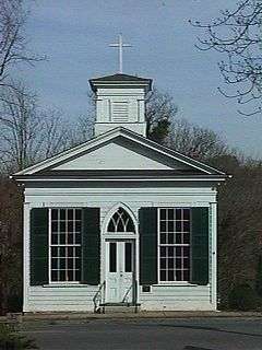
St. Luke's Chapel |
|
000000001991-09-26-0000September 26, 1991
(#91001470) |
Junction of Hospital Dr. and Old Twitty Ford Rd.
35°21′41″N 81°57′56″W / 35.361389°N 81.965556°W / 35.361389; -81.965556 (St. Luke's Chapel) |
Rutherfordton |
|
| 23 |
Trinity Lutheran Church |
|
000000001972-03-24-0000March 24, 1972
(#72000997) |
702 N. Main St.
35°22′21″N 81°57′19″W / 35.3725°N 81.955278°W / 35.3725; -81.955278 (Trinity Lutheran Church) |
Rutherfordton |
|
| 24 |
Washburn Historic District |
|
000000002002-02-20-0000February 20, 2002
(#02000056) |
2401, 2426, and 2436 Bostic-Sunshine Highway, 1391 and 1392 Andrews Mill Rd., 126-156 and 157 Salem Church Rd.; also 1037 Gun Club Rd.
35°23′42″N 81°48′59″W / 35.395°N 81.816389°W / 35.395; -81.816389 (Washburn Historic District) |
Bostic |
1037 Gun Club represents a boundary increase of 000000002006-01-25-0000January 25, 2006
|
| 25 |
T. Max Watson House |
|
000000002001-10-15-0000October 15, 2001
(#01001110) |
297 E. Main St.
35°19′58″N 81°51′33″W / 35.332778°N 81.859167°W / 35.332778; -81.859167 (T. Max Watson House) |
Forest City |
|
| 26 |
West Main Street Historic District |
|
000000002006-12-20-0000December 20, 2006
(#06001142) |
121 Cool Springs Dr., 343-499 W. Maine St., and 121 Memorial Dr.
35°20′20″N 81°52′23″W / 35.338889°N 81.873056°W / 35.338889; -81.873056 (West Main Street Historic District) |
Forest City |
|