| [3] |
Name on the Register[4] |
Image |
Date listed[5] |
Location |
City or town |
Description |
|---|
| 1 |
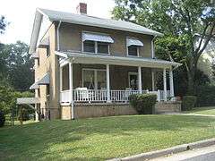
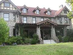
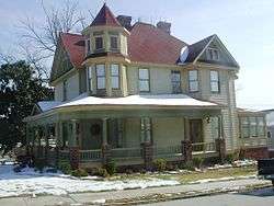
John H. Adams House |
Upload image |
000000002001-01-11-0000January 11, 2001
(#00001641) |
1108 N. Main St.
35°58′10″N 80°00′56″W / 35.969444°N 80.015556°W / 35.969444; -80.015556 (John H. Adams House) |
High Point |
|
| 2 |
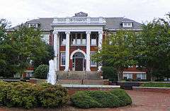
Agricultural and Technical College of North Carolina Historic District |
|
000000001988-10-20-0000October 20, 1988
(#88002046) |
E. side of Dudley St. between Bluford St. and Headen Dr.
36°04′28″N 79°46′39″W / 36.074444°N 79.7775°W / 36.074444; -79.7775 (Agricultural and Technical College of North Carolina Historic District) |
Greensboro |
|
| 3 |
Col. Isaac Beeson House |
Upload image |
000000001980-10-16-0000October 16, 1980
(#80002836) |
South of Colfax
36°04′29″N 80°01′20″W / 36.074722°N 80.022222°W / 36.074722; -80.022222 (Col. Isaac Beeson House) |
Colfax |
|
| 4 |
Charles Benbow House |
Upload image |
000000001982-08-19-0000August 19, 1982
(#82004842) |
South of Oak Ridge on NC 150
36°09′49″N 79°59′33″W / 36.163611°N 79.9925°W / 36.163611; -79.9925 (Charles Benbow House) |
Oak Ridge |
|
| 5 |
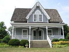
Jesse Benbow House II |
Upload image |
000000001983-09-08-0000September 8, 1983
(#83001885) |
NC 150
36°09′50″N 80°00′08″W / 36.163889°N 80.002222°W / 36.163889; -80.002222 (Jesse Benbow House II) |
Oak Ridge |
|
| 6 |
Bennett College Historic District |
Upload image |
000000001992-04-03-0000April 3, 1992
(#92000179) |
Roughy bounded by E. Washington, Bennett and Gorrell Sts.
36°04′03″N 79°46′47″W / 36.0675°N 79.779722°W / 36.0675; -79.779722 (Bennett College Historic District) |
Greensboro |
|
| 7 |
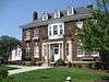
Blandwood |
|
000000001970-04-17-0000April 17, 1970
(#70000455) |
447 W. Washington St.
36°04′09″N 79°47′38″W / 36.069167°N 79.793889°W / 36.069167; -79.793889 (Blandwood) |
Greensboro |
|
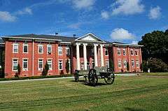
| 8 |
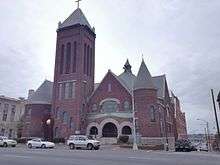
Buffalo Presbyterian Church and Cemetery |
|
000000002002-09-16-0000September 16, 2002
(#02000985) |
800 and 803 Sixteenth St.
36°06′33″N 79°46′49″W / 36.109167°N 79.780278°W / 36.109167; -79.780278 (Buffalo Presbyterian Church and Cemetery) |
Greensboro |
|
| 9 |
Bumpas-Troy House |
|
000000001977-12-06-0000December 6, 1977
(#77001000) |
114 S. Mendenhall St.
36°04′20″N 79°48′12″W / 36.072222°N 79.803333°W / 36.072222; -79.803333 (Bumpas-Troy House) |
Greensboro |
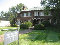
|
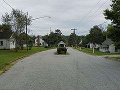
| 10 |
David Caldwell Log College Site |
Upload image |
000000001982-01-13-0000January 13, 1982
(#82003456) |
Address Restricted
|
Greensboro |
|
| 11 |
Carolina Cadillac Company Building |
Upload image |
000000002014-08-25-0000August 25, 2014
(#14000520) |
304 E. Market St.
36°04′19″N 79°47′12″W / 36.0720°N 79.7866°W / 36.0720; -79.7866 (Carolina Cadillac Company Building) |
Greensboro |
|
| 12 |
Carolina Casket Company |
Upload image |
000000002015-04-15-0000April 15, 2015
(#15000163) |
812 Millis St.
35°56′54″N 80°00′59″W / 35.9483°N 80.0163°W / 35.9483; -80.0163 (Carolina Casket Company) |
High Point |
|
| 13 |
Wilbur and Martha Carter House |
|
000000002008-08-13-0000August 13, 2008
(#08000777) |
1012 Country Club Dr.
36°05′56″N 79°48′32″W / 36.098786°N 79.809008°W / 36.098786; -79.809008 (Wilbur and Martha Carter House) |
Greensboro |
|
| 14 |
Central Fire Station |
|
000000001980-04-28-0000April 28, 1980
(#80002837) |
318 N. Greene St.
36°04′33″N 79°47′29″W / 36.075833°N 79.791389°W / 36.075833; -79.791389 (Central Fire Station) |
Greensboro |
|
| 15 |
College Hill Historic District |
|
000000001993-11-04-0000November 4, 1993
(#93001191) |
Roughly bounded by W. Market St., S. Cedar St., Oakland Ave. and McIver St.
36°04′08″N 79°48′12″W / 36.068889°N 79.803333°W / 36.068889; -79.803333 (College Hill Historic District) |
Greensboro |
|
| 16 |
Deep River Friends Meeting House and Cemetery |
Upload image |
000000001995-12-13-0000December 13, 1995
(#95001448) |
5300 W. Wendover Ave.
36°01′53″N 79°57′55″W / 36.031389°N 79.965278°W / 36.031389; -79.965278 (Deep River Friends Meeting House and Cemetery) |
High Point |
|
| 17 |
Dixon-Leftwich-Murphy House |
|
000000001982-09-23-0000September 23, 1982
(#82003457) |
507 Church St.
36°04′46″N 79°47′13″W / 36.079444°N 79.786944°W / 36.079444; -79.786944 (Dixon-Leftwich-Murphy House) |
Greensboro |
|
| 18 |
Downtown Greensboro Historic District |
|
000000001982-06-17-0000June 17, 1982
(#82003458) |
Elm, S. Davie, S. Green, and E. and W. Washington Sts.
36°04′07″N 79°47′25″W / 36.068611°N 79.790278°W / 36.068611; -79.790278 (Downtown Greensboro Historic District) |
Greensboro |
|
| 19 |
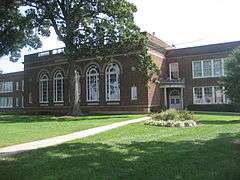
James Benson Dudley Senior High School and Gymnasium |
|
000000002003-04-11-0000April 11, 2003
(#03000302) |
1200 Lincoln St.
36°03′35″N 79°45′54″W / 36.059722°N 79.765°W / 36.059722; -79.765 (James Benson Dudley Senior High School and Gymnasium) |
Greensboro |
|
| 20 |
Endsley-Morgan House |
Upload image |
000000001984-10-25-0000October 25, 1984
(#84000117) |
Off U.S. 421
36°07′23″N 80°00′51″W / 36.123056°N 80.014167°W / 36.123056; -80.014167 (Endsley-Morgan House) |
Colfax |
|
| 21 |
Enterprise Building |
|
000000002014-12-02-0000December 2, 2014
(#14000985) |
305 N. Main St.
35°57′34″N 80°00′26″W / 35.9594°N 80.0073°W / 35.9594; -80.0073 (Enterprise Building) |
High Point |
|
| 22 |
William Fields House |
|
000000001985-12-05-0000December 5, 1985
(#85003084) |
447 Arlington St.
36°03′54″N 79°47′21″W / 36.065°N 79.789167°W / 36.065; -79.789167 (William Fields House) |
Greensboro |
|
| 23 |
First Baptist Church |
Upload image |
000000002009-01-08-0000January 8, 2009
(#08001289) |
701 E. Washington Dr.
35°57′41″N 79°59′59″W / 35.961408°N 79.999703°W / 35.961408; -79.999703 (First Baptist Church) |
High Point |
Scheduled for demolition[6]
|
| 24 |
Fisher Park Historic District |
|
000000001992-01-22-0000January 22, 1992
(#91002006) |
Roughly bounded by Fisher and Bessemer Aves. and Wharton and Church Sts.; also 507 N. Church St.
36°04′59″N 79°47′26″W / 36.083056°N 79.790556°W / 36.083056; -79.790556 (Fisher Park Historic District) |
Greensboro |
507 Church represents a boundary increase of 000000001996-09-12-0000September 12, 1996
|
| 25 |
Former East White Oak School |
|
000000001992-04-21-0000April 21, 1992
(#92000360) |
1801 Tenth St.
36°06′04″N 79°45′37″W / 36.101111°N 79.760278°W / 36.101111; -79.760278 (Former East White Oak School) |
Greensboro |
|
| 26 |
Former Jamestown High School |
|
000000001991-12-06-0000December 6, 1991
(#91001779) |
200 W. Main St.
35°59′36″N 79°56′21″W / 35.993333°N 79.939167°W / 35.993333; -79.939167 (Former Jamestown High School) |
Jamestown |
|
| 27 |
Former Charles D. McIver School |
|
000000001992-04-03-0000April 3, 1992
(#92000177) |
643 W. Gate City Blvd.
36°03′47″N 79°48′04″W / 36.063056°N 79.801111°W / 36.063056; -79.801111 (Former Charles D. McIver School) |
Greensboro |
Currently used as a church.
|
| 28 |
Former Pomona High School |
Upload image |
000000001995-02-24-0000February 24, 1995
(#92001888) |
221 Spring Garden St.
36°03′47″N 79°49′48″W / 36.063056°N 79.83°W / 36.063056; -79.83 (Former Pomona High School) |
Greensboro |
|
| 29 |
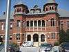
Former L. Richardson Memorial Hospital |
|
000000001992-04-03-0000April 3, 1992
(#92000180) |
603 S. Benbow Rd.
36°04′04″N 79°46′14″W / 36.067778°N 79.770556°W / 36.067778; -79.770556 (Former L. Richardson Memorial Hospital) |
Greensboro |
|
| 30 |
Edward J. Forney House |
|
000000001992-04-21-0000April 21, 1992
(#92000359) |
1402 Spring Garden St.
36°03′56″N 79°48′48″W / 36.065556°N 79.813333°W / 36.065556; -79.813333 (Edward J. Forney House) |
Greensboro |
|
| 31 |
Daniel P. Foust House |
Upload image |
000000002005-01-20-0000January 20, 2005
(#04001522) |
439 Brightwood Church Rd.
36°04′40″N 79°34′48″W / 36.077778°N 79.58°W / 36.077778; -79.58 (Daniel P. Foust House) |
Whitsett |
|
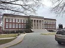
| 32 |
Julius I. Foust Building |
|
000000001980-09-11-0000September 11, 1980
(#80002838) |
1000 W. Spring Garden St.
36°04′01″N 79°48′29″W / 36.066944°N 79.808056°W / 36.066944; -79.808056 (Julius I. Foust Building) |
Greensboro |
|
| 33 |
Foust-Carpenter and Dean Dick Farms |
Upload image |
000000002009-07-01-0000July 1, 2009
(#09000504) |
East and west sides of Mt. Hope Church Rd. and north and south sides of Carpenter House Rd.
36°01′26″N 79°37′53″W / 36.023889°N 79.631389°W / 36.023889; -79.631389 (Foust-Carpenter and Dean Dick Farms) |
Whitsett |
|
| 34 |
John Marion Galloway House |
|
000000001983-07-21-0000July 21, 1983
(#83001886) |
1007 N. Elm St.
36°05′11″N 79°47′24″W / 36.086389°N 79.79°W / 36.086389; -79.79 (John Marion Galloway House) |
Greensboro |
|
| 35 |
Gardner House |
Upload image |
000000001974-10-15-0000October 15, 1974
(#74001350) |
East of Jamestown on SR 1383
35°59′19″N 79°53′28″W / 35.988611°N 79.891111°W / 35.988611; -79.891111 (Gardner House) |
Jamestown |
|
| 36 |
Gibsonville School |
Upload image |
000000002014-08-18-0000August 18, 2014
(#14000495) |
500 Church St.
36°06′36″N 79°32′39″W / 36.1101°N 79.5441°W / 36.1101; -79.5441 (Gibsonville School) |
Gibsonville |
|
| 37 |
Dr. C. S. Grayson House |
Upload image |
000000001994-03-17-0000March 17, 1994
(#94000190) |
1009 N. Main St.
35°58′05″N 80°00′55″W / 35.968056°N 80.015278°W / 35.968056; -80.015278 (Dr. C. S. Grayson House) |
High Point |
|
| 38 |
Green Hill Cemetery Gatekeeper's House |
|
000000001979-05-29-0000May 29, 1979
(#79001713) |
700 Battleground Ave.
36°04′47″N 79°47′43″W / 36.079722°N 79.795278°W / 36.079722; -79.795278 (Green Hill Cemetery Gatekeeper's House) |
Greensboro |
|
| 39 |
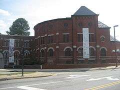
Greensboro Historical Museum |
|
000000001985-04-25-0000April 25, 1985
(#85000877) |
130 Summit Ave.
36°04′32″N 79°47′17″W / 36.075556°N 79.788056°W / 36.075556; -79.788056 (Greensboro Historical Museum) |
Greensboro |
|
| 40 |
Greensboro Senior High School |
|
000000002005-09-07-0000September 7, 2005
(#05000957) |
801 Westover Terrace
36°05′02″N 79°48′57″W / 36.083889°N 79.815833°W / 36.083889; -79.815833 (Greensboro Senior High School) |
Greensboro |
|
| 41 |
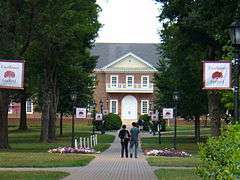
Guilford College |
|
000000001990-06-21-0000June 21, 1990
(#90000855) |
5800 W. Friendly Ave.
36°05′40″N 79°52′58″W / 36.094444°N 79.882778°W / 36.094444; -79.882778 (Guilford College) |
Greensboro |
|
| 42 |
Guilford County Courthouse |
|
000000001979-05-10-0000May 10, 1979
(#79001714) |
Market St.
36°04′20″N 79°47′34″W / 36.072222°N 79.792778°W / 36.072222; -79.792778 (Guilford County Courthouse) |
Greensboro |
|
| 43 |
Guilford County Office and Court Building |
Upload image |
000000001988-12-20-0000December 20, 1988
(#88002843) |
258 S. Main St.
35°57′14″N 80°00′20″W / 35.953889°N 80.005556°W / 35.953889; -80.005556 (Guilford County Office and Court Building) |
High Point |
|
| 44 |
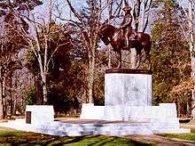
Guilford Courthouse National Military Park |
|
000000001966-10-15-0000October 15, 1966
(#66000069) |
Address Restricted
|
Greensboro |
|
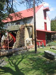
| 45 |
Guilford Mill |
|
000000001982-08-02-0000August 2, 1982
(#82003462) |
Southeast of Oak Ridge on NC 68
36°09′38″N 79°58′41″W / 36.160556°N 79.978056°W / 36.160556; -79.978056 (Guilford Mill) |
Oak Ridge |
|
| 46 |
John Haley House |
Upload image |
000000001971-08-26-0000August 26, 1971
(#71000587) |
1805 E. Lexington Ave.
35°58′49″N 79°59′42″W / 35.980278°N 79.995°W / 35.980278; -79.995 (John Haley House) |
High Point |
|
| 47 |
Hardee Apartments |
Upload image |
000000001991-03-14-0000March 14, 1991
(#91000260) |
1102 N. Main St.
35°58′09″N 80°00′54″W / 35.969167°N 80.015°W / 35.969167; -80.015 (Hardee Apartments) |
High Point |
|
| 48 |
Highland Cotton Mills Village Historic District |
Upload image |
000000002014-05-23-0000May 23, 2014
(#14000263) |
Roughly bounded by W. Market Center Dr., Connor, Jordan & Young Pls., S. Elm St.
35°56′10″N 80°00′43″W / 35.9360°N 80.0120°W / 35.9360; -80.0120 (Highland Cotton Mills Village Historic District) |
High Point |
|
| 49 |
Hillsdale Brick Store |
Upload image |
000000001982-06-14-0000June 14, 1982
(#82003459) |
NC 150 and SR 2347
36°12′00″N 79°50′39″W / 36.199997°N 79.844092°W / 36.199997; -79.844092 (Hillsdale Brick Store) |
Hillsdale |
|
| 50 |
Hillside |
|
000000001980-02-01-0000February 1, 1980
(#80002839) |
301 Fisher Park Circle
36°04′32″N 79°47′34″W / 36.075556°N 79.792778°W / 36.075556; -79.792778 (Hillside) |
Greensboro |
|
| 51 |
Holly Gate |
Upload image |
000000001980-09-22-0000September 22, 1980
(#80002840) |
NC 61
36°04′18″N 79°33′50″W / 36.071667°N 79.563889°W / 36.071667; -79.563889 (Holly Gate) |
Whitsett |
|
| 52 |
Hoskins House Historic District |
|
000000001988-03-15-0000March 15, 1988
(#88000175) |
Intersection of New Garden Rd. and US 220
36°08′19″N 79°51′10″W / 36.138611°N 79.852778°W / 36.138611; -79.852778 (Hoskins House Historic District) |
Greensboro |
|
| 53 |
Charles H. Ireland House |
|
000000001979-05-29-0000May 29, 1979
(#79001715) |
602 W. Friendly Ave.
36°04′26″N 79°47′51″W / 36.073889°N 79.7975°W / 36.073889; -79.7975 (Charles H. Ireland House) |
Greensboro |
Destroyed by fire February 2, 1996
|
| 54 |
Irving Park Historic District |
Upload image |
000000001995-02-21-0000February 21, 1995
(#94001050) |
Roughly bounded by Buffalo Cr., Battleground Ave., Cornwallis Dr. and W. Northwood St.
36°05′47″N 79°47′54″W / 36.096389°N 79.798333°W / 36.096389; -79.798333 (Irving Park Historic District) |
Greensboro |
|
| 55 |
Jamestown Historic District |
Upload image |
000000001973-01-22-0000January 22, 1973
(#73001345) |
Both sides of U.S. 29A
35°59′40″N 79°56′44″W / 35.994444°N 79.945556°W / 35.994444; -79.945556 (Jamestown Historic District) |
Jamestown |
|
| 56 |
Allen Jay School Rock Gymnasium |
|
000000002012-08-28-0000August 28, 2012
(#12000574) |
1201 E. Fairfield Rd.
35°55′33″N 79°57′38″W / 35.925904°N 79.960644°W / 35.925904; -79.960644 (Allen Jay School Rock Gymnasium) |
High Point |
|
| 57 |
Jefferson Standard Building |
|
000000001976-05-28-0000May 28, 1976
(#76001326) |
Elm and Market Sts.
36°04′22″N 79°47′32″W / 36.072778°N 79.792222°W / 36.072778; -79.792222 (Jefferson Standard Building) |
Greensboro |
|
| 58 |
Kellenberger Estate |
Upload image |
000000001994-03-17-0000March 17, 1994
(#94000218) |
1415 Kellenberger Rd.
36°03′13″N 79°40′19″W / 36.053611°N 79.671944°W / 36.053611; -79.671944 (Kellenberger Estate) |
Greensboro |
|
| 59 |
Kilby Hotel |
Upload image |
000000001982-04-22-0000April 22, 1982
(#82003460) |
627 E. Washington St.
35°57′40″N 80°00′02″W / 35.961111°N 80.000556°W / 35.961111; -80.000556 (Kilby Hotel) |
High Point |
|
| 60 |
Kimrey-Haworth House |
|
000000001991-03-14-0000March 14, 1991
(#91000265) |
5307 W. Friendly Ave.
36°05′20″N 79°52′43″W / 36.088889°N 79.878611°W / 36.088889; -79.878611 (Kimrey-Haworth House) |
Greensboro |
|
| 61 |
O. Arthur Kirkman House and Outbuildings |
Upload image |
000000001988-01-28-0000January 28, 1988
(#87002567) |
501 W. High St.; also 106 Oak St.
35°57′13″N 80°00′42″W / 35.953611°N 80.011667°W / 35.953611; -80.011667 (O. Arthur Kirkman House and Outbuildings) |
High Point |
106 Oak represents a boundary increase of 000000001989-06-09-0000June 9, 1989
|
| 62 |
Latham-Baker House |
|
000000001982-11-12-0000November 12, 1982
(#82001298) |
412 Fisher Park Circle
36°04′56″N 79°47′30″W / 36.082222°N 79.791667°W / 36.082222; -79.791667 (Latham-Baker House) |
Greensboro |
|
| 63 |
Low House |
Upload image |
000000001978-03-08-0000March 8, 1978
(#78001957) |
South of Gibsonville
36°02′59″N 79°34′13″W / 36.049722°N 79.570278°W / 36.049722; -79.570278 (Low House) |
Whitsett |
|
| 64 |
Lyndon Street Townhouses |
|
000000001992-04-03-0000April 3, 1992
(#92000178) |
195-201 Lyndon St.
36°04′16″N 79°47′07″W / 36.071111°N 79.785278°W / 36.071111; -79.785278 (Lyndon Street Townhouses) |
Greensboro |
|
| 65 |
Harden Thomas Martin House |
|
000000001985-12-19-0000December 19, 1985
(#85003217) |
204 N. Mendenhall St.
36°04′28″N 79°48′09″W / 36.074444°N 79.8025°W / 36.074444; -79.8025 (Harden Thomas Martin House) |
Greensboro |
|
| 66 |
McCulloch's Gold Mill |
|
000000001979-04-24-0000April 24, 1979
(#79001717) |
Address Restricted
|
Jamestown |
|
| 67 |
Dr. Joseph A. McLean House |
Upload image |
000000001995-02-02-0000February 2, 1995
(#94001632) |
US 70 north side, 0.1 miles (0.16 km) west of junction with SR 3053
36°04′15″N 79°37′54″W / 36.070833°N 79.631667°W / 36.070833; -79.631667 (Dr. Joseph A. McLean House) |
Sedalia |
|
| 68 |
Richard Mendenhall Plantation Buildings |
|
000000001972-11-03-0000November 3, 1972
(#72000964) |
U.S. 29
35°59′34″N 79°56′56″W / 35.992778°N 79.948889°W / 35.992778; -79.948889 (Richard Mendenhall Plantation Buildings) |
Jamestown |
|
| 69 |
Mock, Judson, Voehringer Company Hosiery Mill |
|
000000002011-03-28-0000March 28, 2011
(#11000141) |
2610 Oakland Ave.
36°03′43″N 79°50′07″W / 36.061944°N 79.835278°W / 36.061944; -79.835278 (Mock, Judson, Voehringer Company Hosiery Mill) |
Greensboro |
Textile mill built between 1927 and 1938[7]
|
| 70 |
Model Farm |
Upload image |
000000002011-04-20-0000April 20, 2011
(#11000208) |
2058 Brentwood St.
35°56′17″N 79°58′42″W / 35.938056°N 79.978333°W / 35.938056; -79.978333 (Model Farm) |
High Point |
|
| 71 |
Oak Ridge Military Academy Historic District |
|
000000001983-03-17-0000March 17, 1983
(#83001887) |
NC 150 and NC 68
36°10′32″N 79°59′13″W / 36.175556°N 79.986944°W / 36.175556; -79.986944 (Oak Ridge Military Academy Historic District) |
Oak Ridge |
|
| 72 |
Oakdale Cotton Mill Village |
|
000000001976-03-15-0000March 15, 1976
(#76001327) |
SR 1352 and SR 1144
35°58′50″N 79°55′48″W / 35.980556°N 79.93°W / 35.980556; -79.93 (Oakdale Cotton Mill Village) |
Jamestown |
|
| 73 |
Oakwood Historic District |
Upload image |
000000001991-02-07-0000February 7, 1991
(#90002197) |
100-300 blocks Oakwood St.
35°57′22″N 80°00′48″W / 35.956111°N 80.013333°W / 35.956111; -80.013333 (Oakwood Historic District) |
High Point |
|
| 74 |
Palmer Memorial Institute Historic District |
Upload image |
000000001988-10-24-0000October 24, 1988
(#88002029) |
Along US 70 west of the junction with NC 3056
36°04′02″N 79°37′25″W / 36.067222°N 79.623611°W / 36.067222; -79.623611 (Palmer Memorial Institute Historic District) |
Sedalia |
|
| 75 |
William Penn High School |
Upload image |
000000001978-11-16-0000November 16, 1978
(#78001959) |
Washington Dr.
35°57′43″N 79°59′51″W / 35.961944°N 79.9975°W / 35.961944; -79.9975 (William Penn High School) |
High Point |
|
| 76 |
Pickett Cotton Mills |
Upload image |
000000002015-09-01-0000September 1, 2015
(#15000558) |
1200 Redding Dr.
35°56′34″N 80°01′00″W / 35.9429°N 80.0168°W / 35.9429; -80.0168 (Pickett Cotton Mills) |
High Point |
|
| 77 |
Proximity Print Works |
Upload image |
000000002014-12-01-0000December 1, 2014
(#14000986) |
1700 Fairview St.
36°06′04″N 79°46′20″W / 36.1012°N 79.7723°W / 36.1012; -79.7723 (Proximity Print Works) |
Greensboro |
|
| 78 |
Ragsdale Farm |
Upload image |
000000001991-09-03-0000September 3, 1991
(#91001171) |
404 E. Main St.
35°59′48″N 79°55′51″W / 35.996667°N 79.930833°W / 35.996667; -79.930833 (Ragsdale Farm) |
Jamestown |
|
| 79 |
Revolution Cotton Mills |
|
000000001984-03-01-0000March 1, 1984
(#84002324) |
Roughly bounded by Southern RR, N. Buffalo Creek, Yanceyville and 9th Sts.
36°05′57″N 79°46′42″W / 36.099167°N 79.778333°W / 36.099167; -79.778333 (Revolution Cotton Mills) |
Greensboro |
|
| 80 |
Thomas Scott House |
Upload image |
000000001984-07-12-0000July 12, 1984
(#84002328) |
SR 1001
36°10′06″N 79°47′28″W / 36.168333°N 79.791111°W / 36.168333; -79.791111 (Thomas Scott House) |
Greensboro |
|
| 81 |
Shaw-Cude House |
Upload image |
000000001982-06-01-0000June 1, 1982
(#82003455) |
Off SR 2010
36°07′26″N 79°59′00″W / 36.123889°N 79.983333°W / 36.123889; -79.983333 (Shaw-Cude House) |
Colfax |
|
| 82 |
Sherrod Park |
Upload image |
000000001991-03-14-0000March 14, 1991
(#91000278) |
200-300 blocks Woodrow Ave.
35°58′08″N 80°00′28″W / 35.968889°N 80.007778°W / 35.968889; -80.007778 (Sherrod Park) |
High Point |
|
| 83 |
Michael Sherwood House |
|
000000001978-01-31-0000January 31, 1978
(#78001958) |
426 W. Friendly Ave.
36°04′26″N 79°47′43″W / 36.073889°N 79.795278°W / 36.073889; -79.795278 (Michael Sherwood House) |
Greensboro |
|
| 84 |
J. C. Siceloff House |
Upload image |
000000001991-03-14-0000March 14, 1991
(#91000264) |
1104 N. Main St.
35°58′09″N 80°00′55″W / 35.969167°N 80.015278°W / 35.969167; -80.015278 (J. C. Siceloff House) |
High Point |
|
| 85 |
Francis Marion Smith House |
Upload image |
000000001984-07-12-0000July 12, 1984
(#84002330) |
204 Railroad Ave.
36°06′15″N 79°32′28″W / 36.104167°N 79.541111°W / 36.104167; -79.541111 (Francis Marion Smith House) |
Gibsonville |
|
| 86 |
William Rankin and Elizabeth Wharton Smith House |
Upload image |
000000002007-02-27-0000February 27, 2007
(#07000091) |
437 Brightwood Church Rd., NC 2758, 0.62 miles (1.00 km) north of US 70
36°04′44″N 79°34′51″W / 36.078889°N 79.580833°W / 36.078889; -79.580833 (William Rankin and Elizabeth Wharton Smith House) |
Whitsett |
|
| 87 |
South Greensboro Historic District |
|
000000001991-12-20-0000December 20, 1991
(#91001812) |
Roughly bounded by Gorrell, Martin, E. Bragg, Sevier, Omaha, Broad, Caldwell, Andrew, Vance, McCulloch, and King Dr.
36°03′40″N 79°47′06″W / 36.061111°N 79.785°W / 36.061111; -79.785 (South Greensboro Historic District) |
Greensboro |
|
| 88 |
Sigmund Sternberger House |
|
000000001993-04-16-0000April 16, 1993
(#93000302) |
712 Summit Ave.
36°04′52″N 79°46′44″W / 36.081111°N 79.778889°W / 36.081111; -79.778889 (Sigmund Sternberger House) |
Greensboro |
|
| 89 |
Summerfield Historic District |
Upload image |
000000002005-05-18-0000May 18, 2005
(#05000437) |
4105-4210 Oak Ridge Rd. and 7702-7804 Summerfield Rd.
36°12′25″N 79°54′21″W / 36.206944°N 79.905833°W / 36.206944; -79.905833 (Summerfield Historic District) |
Summerfield |
|
| 90 |
Summerfield School Gymnasium and Community Center |
Upload image |
000000002012-08-28-0000August 28, 2012
(#12000575) |
7515 Trainer Dr.
36°12′01″N 79°54′18″W / 36.2002°N 79.905068°W / 36.2002; -79.905068 (Summerfield School Gymnasium and Community Center) |
Summerfield |
|
| 91 |
Summit Avenue Historic District |
|
000000001993-08-05-0000August 5, 1993
(#93000768) |
Roughly bounded by Chestnut, E. Bessemer, Cypress, Dewey, Park, and Percy Sts.
36°04′54″N 79°46′55″W / 36.081667°N 79.781944°W / 36.081667; -79.781944 (Summit Avenue Historic District) |
Greensboro |
|
| 92 |
Sunset Hills Historic District |
Upload image |
000000002013-01-17-0000January 17, 2013
(#12001179) |
Bounded by W. Friendly, N. & S. Elam & W. Wright Aves., S. Tremont Dr., N. Aycock St. & Kensington Rd.
36°04′24″N 79°49′16″W / 36.073245°N 79.82102°W / 36.073245; -79.82102 (Sunset Hills Historic District) |
Greensboro |
|
| 93 |
Tabernacle Methodist Protestant Church and Cemetery |
|
000000001995-03-10-0000March 10, 1995
(#95000231) |
5601 Liberty Rd.
35°57′55″N 79°41′49″W / 35.965278°N 79.696944°W / 35.965278; -79.696944 (Tabernacle Methodist Protestant Church and Cemetery) |
Greensboro |
|
| 94 |
A. E. Taplin Apartment Building |
Upload image |
000000001996-03-01-0000March 1, 1996
(#96000196) |
408 W. Parkway Ave.
35°58′03″N 80°01′11″W / 35.9675°N 80.019722°W / 35.9675; -80.019722 (A. E. Taplin Apartment Building) |
High Point |
|
| 95 |
Tomlinson Chair Manufacturing Company Complex |
Upload image |
000000001983-03-17-0000March 17, 1983
(#83001888) |
305 W. High St.
35°57′18″N 80°00′33″W / 35.955°N 80.009167°W / 35.955; -80.009167 (Tomlinson Chair Manufacturing Company Complex) |
High Point |
|
| 96 |
Union Cemetery |
|
000000001993-10-21-0000October 21, 1993
(#93001142) |
900 blook S. Elm St.
36°03′31″N 79°47′29″W / 36.058611°N 79.791389°W / 36.058611; -79.791389 (Union Cemetery) |
Greensboro |
|
| 97 |
United States Post Office and Court House |
Upload image |
000000002014-10-29-0000October 29, 2014
(#14000886) |
324 W. Market St.
36°04′24″N 79°47′37″W / 36.0732°N 79.7936°W / 36.0732; -79.7936 (United States Post Office and Court House) |
Greensboro |
|
| 98 |
Uptown Suburbs Historic District |
Upload image |
000000002013-01-09-0000January 9, 2013
(#12001158) |
Roughly bounded by W. Lexington & Sunset Aves., Westchester Dr., Johnson & W. Ray Sts.
35°58′09″N 80°01′23″W / 35.969046°N 80.023087°W / 35.969046; -80.023087 (Uptown Suburbs Historic District) |
High Point |
|
| 99 |
Wadsworth Congregational Church |
Upload image |
000000002002-12-31-0000December 31, 2002
(#02001659) |
1301 Rock Creek Dairy Rd.
36°02′49″N 79°35′52″W / 36.046944°N 79.597778°W / 36.046944; -79.597778 (Wadsworth Congregational Church) |
Whitsett |
|
| 100 |
Wafco Mills |
|
000000001979-05-30-0000May 30, 1979
(#79001716) |
801 McGee St.
36°04′07″N 79°47′56″W / 36.068611°N 79.798889°W / 36.068611; -79.798889 (Wafco Mills) |
Greensboro |
|
| 101 |
Simeon Wagoner House |
Upload image |
000000001991-09-03-0000September 3, 1991
(#91001172) |
5838 NC 61 (Friedens Church Rd.)
36°07′31″N 79°33′31″W / 36.125278°N 79.558611°W / 36.125278; -79.558611 (Simeon Wagoner House) |
Gibsonville |
|
| 102 |
Washington Street Historic District |
Upload image |
000000002010-12-28-0000December 28, 2010
(#10001094) |
Portions of eight blocks on Washington, Centennial, Fourth, and Hobson Sts., Eccles Pl., and Gaylord Ct.
35°57′40″N 80°00′08″W / 35.961111°N 80.002222°W / 35.961111; -80.002222 (Washington Street Historic District) |
High Point |
|
| 103 |
Dr. David P. Weir House |
|
000000001984-07-12-0000July 12, 1984
(#84002332) |
223 N. Edgeworth St.
36°04′28″N 79°47′48″W / 36.074444°N 79.796667°W / 36.074444; -79.796667 (Dr. David P. Weir House) |
Greensboro |
|
| 104 |
West High Street Historic District |
Upload image |
000000002007-04-12-0000April 12, 2007
(#07000295) |
407,409,415,501,503 and 507 W. High St., 106,107 and 110 Oak St.
35°57′20″N 80°00′41″W / 35.955556°N 80.011389°W / 35.955556; -80.011389 (West High Street Historic District) |
High Point |
|
| 105 |
West Market Street Methodist Episcopal Church, South |
|
000000001985-12-19-0000December 19, 1985
(#85003198) |
302 W. Market St.
36°04′25″N 79°47′36″W / 36.073611°N 79.793333°W / 36.073611; -79.793333 (West Market Street Methodist Episcopal Church, South) |
Greensboro |
|
| 106 |
White Oak New Town Historic District |
|
000000001992-04-03-0000April 3, 1992
(#92000176) |
2400-2418 N. Church, 2312-2509 Spruce, 2310-2503 Hubbard and 2401-2503 Cypress Sts.
36°06′23″N 79°46′45″W / 36.106389°N 79.779167°W / 36.106389; -79.779167 (White Oak New Town Historic District) |
Greensboro |
|
| 107 |
Whitsett Historic District |
Upload image |
000000001999-05-05-0000May 5, 1999
(#99000532) |
Junction NC 61 and NC 3064
36°04′06″N 79°33′49″W / 36.068333°N 79.563611°W / 36.068333; -79.563611 (Whitsett Historic District) |
Whitsett |
|
| 108 |
James H. and Anne B. Willis House |
Upload image |
000000002015-04-23-0000April 23, 2015
(#15000181) |
707 Blair St.
36°05′38″N 79°48′13″W / 36.0938°N 79.8036°W / 36.0938; -79.8036 (James H. and Anne B. Willis House) |
Greensboro |
|
| 109 |
Lucy and J. Vassie Wilson House |
Upload image |
000000002005-05-04-0000May 4, 2005
(#05000378) |
425 Hillcrest Dr.
35°58′26″N 80°01′39″W / 35.973889°N 80.0275°W / 35.973889; -80.0275 (Lucy and J. Vassie Wilson House) |
High Point |
|
| 110 |
World War Memorial Stadium |
|
000000002001-04-12-0000April 12, 2001
(#01000377) |
510 Yanceyville St.
36°04′47″N 79°46′38″W / 36.0797°N 79.7772°W / 36.0797; -79.7772 (World War Memorial Stadium) |
Greensboro |
|

_1.jpg)
_1.jpg)
_1.jpg)
.jpg)
_1.jpg)
_1.jpg)

_1.jpg)
_1.jpg)
_1.jpg)
_1.jpg)
_1.jpg)
_1.jpg)
_2.jpg)
_1.jpg)
_1.jpg)
_1.jpg)
_1.jpg)
_1.jpg)
.jpg)
_1.jpg)
_1.jpg)
_1.jpg)
_first_building.jpg)
_1.jpg)
_2.jpg)
_1.jpg)