Mambajao
| Mambajao | ||
|---|---|---|
| Municipality | ||
|
Mambajao, viewed from Mt. Hibok-hibok | ||
| ||
| Nickname(s): Lanzones Capital of the Philippines | ||
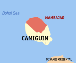
 Map of Camiguin with Mambajao highlighted | ||
.svg.png) Mambajao Location within the Philippines | ||
| Coordinates: 9°15′N 124°43′E / 9.25°N 124.72°ECoordinates: 9°15′N 124°43′E / 9.25°N 124.72°E | ||
| Country | Philippines | |
| Region | Northern Mindanao (Region X) | |
| Province | Camiguin | |
| District | Lone district | |
| Founded | July 6, 1855 | |
| Barangays | 15 | |
| Government[1] | ||
| • Mayor | Maria Luisa D. Romualdo (NPC) | |
| • Vice Mayor | Roldan A. Chan (NPC) | |
| Area[2] | ||
| • Total | 89 km2 (34 sq mi) | |
| Population (2015 census)[3] | ||
| • Total | 38,735 | |
| • Density | 440/km2 (1,100/sq mi) | |
| Time zone | PST (UTC+8) | |
| ZIP code | 9100 | |
| IDD : area code | +63 (0)88 | |
| Website |
www | |
Mambajao is a third class municipality in the province of Camiguin, Philippines. It is the capital and largest municipality of Camiguin.[2] According to the 2015 census, it has a population of 38,735 people.[3]
History
In 1855, Mambajao was proclaimed as a municipality.
In 1942, the Japanese forces landed in the capital town of Mambajao, Camiguin.
In 1945, the Filipino forces of the 6th and 10th Infantry Division of the Philippine Commonwealth Army landed on the beaches of the capital town of Mambajao, and liberated the province from the Japanese Imperial forces in World War II during the Battle of Camiguin.
Barangays
Mambajao is politically subdivided into 16 barangays.[2][4]
- Tupsan
- Benhaan
- Magting
- Anito
- Balbagon
- Pandan
- Soro-Soro
- Poblacion
- Baylao
- Tagdo
- Kuguita
- Bug ong
- Agoho
- Yumbing
- Naasag
- Volcan
Demographics
| Population census of Mambajao | ||
|---|---|---|
| Year | Pop. | ±% p.a. |
| 1990 | 25,207 | — |
| 1995 | 27,770 | +1.83% |
| 2000 | 30,809 | +2.25% |
| 2007 | 35,308 | +1.90% |
| 2010 | 36,435 | +1.15% |
| 2015 | 38,735 | +1.17% |
| Source: Philippine Statistics Authority[3][5][6] | ||
In the 2015 census, the population of Mambajao was 38,735 people,[3] with a density of 440 inhabitants per square kilometre or 1,100 inhabitants per square mile.
References
- ↑ "Municipalities". Quezon City, Philippines: Department of the Interior and Local Government. Retrieved 30 January 2013.
- 1 2 3 "Province: Camiguin". PSGC Interactive. Makati City, Philippines: National Statistical Coordination Board. Retrieved 30 January 2013.
- 1 2 3 4 "Region X (NORTHERN MINDANAO)". Census of Population (2015): Total Population by Province, City, Municipality and Barangay (Report). PSA. Retrieved 20 June 2016.
- ↑ Political subdivisions of Mambajao - Mambajao Official Website
- ↑ "Region X (NORTHERN MINDANAO)". Census of Population and Housing (2010): Total Population by Province, City, Municipality and Barangay (Report). NSO. Retrieved 29 June 2016.
- ↑ "Province of Camiguin". Municipality Population Data. LWUA Research Division. Retrieved 16 August 2013.
External links
| Wikimedia Commons has media related to Mambajao. |
 |
Bohol Sea | |
Bohol Sea |  |
| |
||||
| ||||
| | ||||
| Catarman | Sagay | Mahinog |


