National Register of Historic Places listings in Gunnison County, Colorado
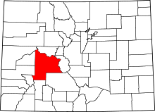
Location of Gunnison County in Colorado
This is a list of the National Register of Historic Places listings in Gunnison County, Colorado.
This is intended to be a complete list of the properties and districts on the National Register of Historic Places in Gunnison County, Colorado, United States. The locations of National Register properties and districts for which the latitude and longitude coordinates are included below, may be seen in a map.[1]
There are 21 properties and districts listed on the National Register in the county.
- This National Park Service list is complete through NPS recent listings posted December 16, 2016.[2]
| Adams - Alamosa - Arapahoe - Archuleta - Baca - Bent - Boulder - Broomfield - Chaffee - Cheyenne - Clear Creek - Conejos - Costilla - Crowley - Custer - Delta - Denver - Dolores - Douglas - Eagle - El Paso - Elbert - Fremont - Garfield - Gilpin - Grand - Gunnison - Hinsdale - Huerfano - Jackson - Jefferson - Kiowa - Kit Carson - La Plata - Lake - Larimer - Las Animas - Lincoln - Logan - Mesa - Mineral - Moffat - Montezuma - Montrose - Morgan - Otero - Ouray - Park - Phillips - Pitkin - Prowers - Pueblo - Rio Blanco - Rio Grande - Routt - Saguache - San Juan - San Miguel - Sedgwick - Summit - Teller - Washington - Weld - Yuma |
Current listings
| [3] | Name on the Register[4] | Image | Date listed[5] | Location | City or town | Description |
|---|---|---|---|---|---|---|
| 1 | Alpine Tunnel Historic District | 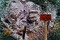 |
(#80004632) |
Along the Denver, South Park and Pacific Railroad tracks from Quartz to Hancock 38°37′46″N 106°24′02″W / 38.6294°N 106.4006°W |
Pitkin | First railroad tunnel over the Continental Divide, now sealed shut. |
| 2 | Chance Gulch Site | Upload image | (#06001102) |
Address Restricted |
Gunnison | |
| 3 | Crested Butte Denver and Rio Grande Railroad Depot | 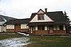 |
(#01000444) |
716 Elk Ave. 38°52′11″N 106°58′41″W / 38.869722°N 106.978056°W |
Crested Butte | |
| 4 | Crystal Mill | 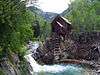 |
(#85001493) |
County Road 3, 7 miles southeast of Marble 39°03′32″N 107°06′14″W / 39.058889°N 107.103889°W |
Crystal | |
| 5 | Curecanti Archeological District | 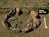 |
(#84000852) |
Curecanti National Recreation Area 38°28′14″N 107°18′05″W / 38.4705°N 107.3015°W |
Gunnison | 5,000 acre area of the Curecanti National Recreation Area[6] |
| 6 | Edgerton House | 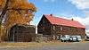 |
(#98000293) |
514 W. Gunnison Ave. 38°32′33″N 106°55′58″W / 38.5425°N 106.932778°W |
Gunnison | |
| 7 | Fisher-Zugelder House and Smith Cottage | 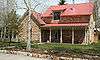 |
(#84000853) |
601 N. Wisconsin St. 38°33′00″N 106°55′41″W / 38.55°N 106.928056°W |
Gunnison | |
| 8 | Gunnison River Bridge I | 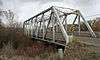 |
(#02001152) |
U.S. Highway 50 service road at milepost 155.41 38°31′58″N 106°57′06″W / 38.532778°N 106.951667°W |
Gunnison | |
| 9 | Gunnison River Bridge II | 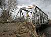 |
(#02001151) |
U.S. Highway 50 service road at milepost 155.59 38°32′02″N 106°56′55″W / 38.533889°N 106.948611°W |
Gunnison | |
| 10 | Haxby House | 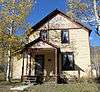 |
(#96000355) |
101 W. Silver 39°04′22″N 107°11′16″W / 39.072778°N 107.187778°W |
Marble | |
| 11 | Marble City State Bank Building | 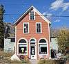 |
(#99001146) |
105 W. Main St. 39°04′19″N 107°11′17″W / 39.071944°N 107.188056°W |
Marble | |
| 12 | Marble High School | 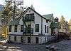 |
(#89000989) |
412 Main St. 39°04′18″N 107°11′32″W / 39.071667°N 107.192222°W |
Marble | |
| 13 | Marble Jailhouse | Upload image | (#16000783) |
209 E. State St. 39°04′16″N 107°11′06″W / 39.071052°N 107.184904°W |
Marble | |
| 14 | Marble Mill Site |  |
(#79000610) |
Park and W. 3rd Sts. 39°04′09″N 107°11′31″W / 39.069167°N 107.191944°W |
Marble | |
| 15 | Marble Town Hall |  |
(#89000988) |
407 Main St. 39°04′19″N 107°11′31″W / 39.071944°N 107.191944°W |
Marble | |
| 16 | William D. Parry House | 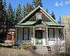 |
(#89000987) |
115 Main St. 39°04′19″N 107°11′19″W / 39.071944°N 107.188611°W |
Marble | |
| 17 | Rimrock School | 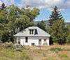 |
(#00001195) |
County Road 24 38°23′21″N 107°29′05″W / 38.389167°N 107.484722°W |
Sapinero | |
| 18 | St. Paul's Church | 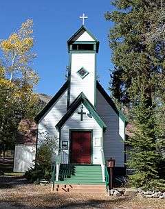 |
(#89000990) |
123 State St. 39°04′16″N 107°11′21″W / 39.071111°N 107.189167°W |
Marble | |
| 19 | Town of Crested Butte |  |
(#74002279) |
Roughly bounded by Maroon Ave., 8th St., White Rock Ave., and 1st St.; also roughly bounded by Gothic Ave., 6th St., White Rock Ave., and 1st St. 38°52′12″N 106°58′39″W / 38.87°N 106.9775°W |
Crested Butte | Second set of addresses represents a boundary increase |
| 20 | Vienna Bakery-Johnson Restaurant | 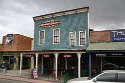 |
(#04001425) |
122-124 N. Main St. 38°32′42″N 106°55′34″W / 38.545°N 106.926111°W |
Gunnison | |
| 21 | Webster Building | 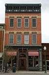 |
(#84000857) |
229 N. Main St. 38°32′45″N 106°55′36″W / 38.545833°N 106.926667°W |
Gunnison |
See also
| Wikimedia Commons has media related to National Register of Historic Places in Gunnison County, Colorado. |
- List of National Historic Landmarks in Colorado
- National Register of Historic Places listings in Colorado
References
- ↑ The latitude and longitude information provided in this table was derived originally from the National Register Information System, which has been found to be fairly accurate for about 99% of listings. For about 1% of NRIS original coordinates, experience has shown that one or both coordinates are typos or otherwise extremely far off; some corrections may have been made. A more subtle problem causes many locations to be off by up to 150 yards, depending on location in the country: most NRIS coordinates were derived from tracing out latitude and longitudes off of USGS topographical quadrant maps created under the North American Datum of 1927, which differs from the current, highly accurate WGS84 GPS system used by most on-line maps. Chicago is about right, but NRIS longitudes in Washington are higher by about 4.5 seconds, and are lower by about 2.0 seconds in Maine. Latitudes differ by about 1.0 second in Florida. Some locations in this table may have been corrected to current GPS standards.
- ↑ "National Register of Historic Places: Weekly List Actions". National Park Service, United States Department of the Interior. Retrieved on December 16, 2016.
- ↑ Numbers represent an ordering by significant words. Various colorings, defined here, differentiate National Historic Landmarks and historic districts from other NRHP buildings, structures, sites or objects.
- ↑ National Park Service (2010-07-09). "National Register Information System". National Register of Historic Places. National Park Service.
- ↑ The eight-digit number below each date is the number assigned to each location in the National Register Information System database, which can be viewed by clicking the number.
- ↑ "Archeology at Curecanti". National Park Service. Retrieved 2012-05-31.
| Topics | |
|---|---|
| Lists by states |
|
| Lists by insular areas | |
| Lists by associated states | |
| Other areas | |
| |
Municipalities and communities of Gunnison County, Colorado, United States | ||
|---|---|---|
| City | | |
| Towns | ||
| Unincorporated communities | ||
| Ghost town | ||
This article is issued from Wikipedia - version of the 12/3/2016. The text is available under the Creative Commons Attribution/Share Alike but additional terms may apply for the media files.