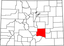
| [3] |
Name on the Register[4] |
Image |
Date listed[5] |
Location |
City or town |
Description |
|---|
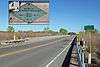
| 1 |
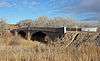
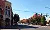
Avondale Bridge |
|
000000001985-02-04-0000February 4, 1985
(#85000225) |
County Road 327
38°14′32″N 104°20′54″W / 38.242222°N 104.348333°W / 38.242222; -104.348333 (Avondale Bridge) |
Avondale |
No longer exists. Replaced in 2005.
|
| 2 |
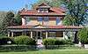
Barndollar-Gann House |
|
000000001985-11-07-0000November 7, 1985
(#85002761) |
1906 Court St.
38°17′06″N 104°36′34″W / 38.285°N 104.609444°W / 38.285; -104.609444 (Barndollar-Gann House) |
Pueblo |
|
| 3 |
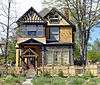
Baxter House |
|
000000001978-02-17-0000February 17, 1978
(#78000876) |
325 W. 15th St.
38°16′51″N 104°36′40″W / 38.280833°N 104.611111°W / 38.280833; -104.611111 (Baxter House) |
Pueblo |
|
| 4 |
Allen J. Beaumont House |
|
000000001983-08-18-0000August 18, 1983
(#83001328) |
425 W. 15th St.
38°16′51″N 104°36′45″W / 38.280833°N 104.6125°W / 38.280833; -104.6125 (Allen J. Beaumont House) |
Pueblo |
|
| 5 |
Dr. John A. Black House Complex |
|
000000001985-11-07-0000November 7, 1985
(#85002760) |
102 W. Pitkin Ave.
38°15′24″N 104°37′29″W / 38.256667°N 104.624722°W / 38.256667; -104.624722 (Dr. John A. Black House Complex) |
Pueblo |
|
| 6 |
Boone Santa Fe Railroad Depot |
|
000000001997-06-27-0000June 27, 1997
(#97000618) |
100 Baker Ave.
38°14′55″N 104°15′23″W / 38.248611°N 104.256389°W / 38.248611; -104.256389 (Boone Santa Fe Railroad Depot) |
Boone |
|
| 7 |
Bowen Mansion |
|
000000001978-01-09-0000January 9, 1978
(#78000877) |
229 W. 12th St.
38°16′42″N 104°36′34″W / 38.278333°N 104.609444°W / 38.278333; -104.609444 (Bowen Mansion) |
Pueblo |
|
| 8 |
Butler House |
Upload image |
000000001984-08-16-0000August 16, 1984
(#84000880) |
6916 Broadacre Rd.
38°00′44″N 104°27′15″W / 38.012222°N 104.454167°W / 38.012222; -104.454167 (Butler House) |
Pueblo |
|
| 9 |
James N. Carlile House |
|
000000001985-02-08-0000February 8, 1985
(#85000297) |
44 Carlile Pl.
38°16′11″N 104°37′43″W / 38.269722°N 104.628611°W / 38.269722; -104.628611 (James N. Carlile House) |
Pueblo |
|
| 10 |
Central High School |
|
000000001979-11-14-0000November 14, 1979
(#79000619) |
431 E. Pitkin Ave.
38°15′11″N 104°37′13″W / 38.253056°N 104.620278°W / 38.253056; -104.620278 (Central High School) |
Pueblo |
|
| 11 |
City Park Carousel |
|
000000001983-04-21-0000April 21, 1983
(#83001297) |
City Park
38°15′44″N 104°39′17″W / 38.262222°N 104.654722°W / 38.262222; -104.654722 (City Park Carousel) |
Pueblo |
|
| 12 |
Colorado Building |
|
000000001992-04-17-0000April 17, 1992
(#92000315) |
401-411 N. Main St.
38°16′15″N 104°36′30″W / 38.270833°N 104.608333°W / 38.270833; -104.608333 (Colorado Building) |
Pueblo |
|
| 13 |
Colorado State Hospital Superintendent's House |
|
000000001985-09-26-0000September 26, 1985
(#85002563) |
13th and Francisco Sts.
38°16′50″N 104°37′26″W / 38.280556°N 104.623889°W / 38.280556; -104.623889 (Colorado State Hospital Superintendent's House) |
Pueblo |
|
| 14 |
Doyle Settlement |
|
000000001980-04-10-0000April 10, 1980
(#80000922) |
Southeast of Pueblo on Doyle Rd.
38°03′30″N 104°24′51″W / 38.058333°N 104.414167°W / 38.058333; -104.414167 (Doyle Settlement) |
Pueblo |
|
| 15 |
Nathaniel W. Duke House |
|
000000001985-02-08-0000February 8, 1985
(#85000229) |
1409 Craig St.
38°16′48″N 104°37′03″W / 38.28°N 104.6175°W / 38.28; -104.6175 (Nathaniel W. Duke House) |
Pueblo |
|
| 16 |
Edison School |
|
000000001985-06-19-0000June 19, 1985
(#85001330) |
900 W. Mesa
38°14′48″N 104°36′06″W / 38.246667°N 104.601667°W / 38.246667; -104.601667 (Edison School) |
Pueblo |
|
| 17 |
El Pueblo |
|
000000001996-02-16-0000February 16, 1996
(#96000039) |
Junction of 1st St. and Union Ave.
38°16′03″N 104°36′35″W / 38.2675°N 104.609722°W / 38.2675; -104.609722 (El Pueblo) |
Pueblo |
|
| 18 |
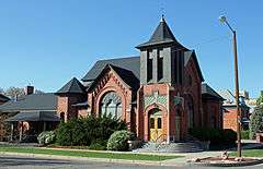
First Congregational Church |
|
000000001985-02-08-0000February 8, 1985
(#85000230) |
225 W. Evans
38°15′37″N 104°37′57″W / 38.260278°N 104.6325°W / 38.260278; -104.6325 (First Congregational Church) |
Pueblo |
|
| 19 |
First Methodist Episcopal Church |
|
000000001979-11-14-0000November 14, 1979
(#79000620) |
400 Broadway St.
38°15′19″N 104°37′23″W / 38.255278°N 104.623056°W / 38.255278; -104.623056 (First Methodist Episcopal Church) |
Pueblo |
|
| 20 |
First Methodist Episcopal Church |
Upload image |
000000002012-04-16-0000April 16, 2012
(#12000201) |
310 W. 11th St.
38°16′37″N 104°36′39″W / 38.2769°N 104.610726°W / 38.2769; -104.610726 (First Methodist Episcopal Church) |
Pueblo |
|
| 21 |
Fitch Terrace |
|
000000001986-10-02-0000October 2, 1986
(#86002809) |
401, 403, 405, 407, 409, and 411 W. 11th St.
38°16′39″N 104°36′42″W / 38.2775°N 104.611667°W / 38.2775; -104.611667 (Fitch Terrace) |
Pueblo |
|
| 22 |
R.T. Frazier House |
|
000000001985-06-19-0000June 19, 1985
(#85001329) |
2121 N. Elizabeth St.
38°17′18″N 104°36′53″W / 38.288333°N 104.614722°W / 38.288333; -104.614722 (R.T. Frazier House) |
Pueblo |
|
| 23 |
Galligan House |
|
000000001982-06-03-0000June 3, 1982
(#82002311) |
501 Colorado Ave.
38°15′19″N 104°37′34″W / 38.255278°N 104.626111°W / 38.255278; -104.626111 (Galligan House) |
Pueblo |
|
| 24 |
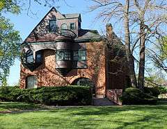
Gast Mansion |
|
000000001982-06-03-0000June 3, 1982
(#82002312) |
1801 Greenwood St.
38°17′02″N 104°36′47″W / 38.283889°N 104.613056°W / 38.283889; -104.613056 (Gast Mansion) |
Pueblo |
|
| 25 |
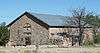
Goodnight Barn |
|
000000001974-07-30-0000July 30, 1974
(#74002278) |
West of Pueblo at State Highway 96 and Siloam Rd.
38°15′26″N 104°41′27″W / 38.257222°N 104.690833°W / 38.257222; -104.690833 (Goodnight Barn) |
Pueblo |
|
| 26 |
Hazelhurst |
|
000000001978-12-15-0000December 15, 1978
(#78000879) |
905 Berkley Ave.
38°15′03″N 104°37′47″W / 38.250833°N 104.629722°W / 38.250833; -104.629722 (Hazelhurst) |
Pueblo |
|
| 27 |
Henkel-Duke Mercantile Company Warehouse |
|
000000001984-05-17-0000May 17, 1984
(#84000881) |
212-222 W. 3rd Ave.
38°16′10″N 104°36′31″W / 38.269444°N 104.608611°W / 38.269444; -104.608611 (Henkel-Duke Mercantile Company Warehouse) |
Pueblo |
|
| 28 |
Huerfano Bridge |
|
000000001985-02-04-0000February 4, 1985
(#85000226) |
U.S. Highway 50
38°13′32″N 104°15′39″W / 38.225556°N 104.260833°W / 38.225556; -104.260833 (Huerfano Bridge) |
Boone |
|
| 29 |
Indian Petroglyphs and Pictographs |
Upload image |
000000001976-05-03-0000May 3, 1976
(#76000566) |
Address Restricted
|
Penrose |
|
| 30 |
Dr. Alexander T. King House and Carriage House |
|
000000001983-04-21-0000April 21, 1983
(#83001329) |
229 Quincy St. and 215 W. Routt Ave.
38°15′33″N 104°37′28″W / 38.259167°N 104.624444°W / 38.259167; -104.624444 (Dr. Alexander T. King House and Carriage House) |
Pueblo |
|
| 31 |
McClelland Orphanage |
|
000000001992-01-30-0000January 30, 1992
(#91002043) |
415 E. Abriendo Ave.
38°15′22″N 104°37′00″W / 38.256111°N 104.616667°W / 38.256111; -104.616667 (McClelland Orphanage) |
Pueblo |
|
| 32 |
Mechanics Building/Masonic Building |
|
000000001983-06-16-0000June 16, 1983
(#83001330) |
207-211 N. Main St.
38°16′09″N 104°36′30″W / 38.269167°N 104.608333°W / 38.269167; -104.608333 (Mechanics Building/Masonic Building) |
Pueblo |
|
| 33 |
Minnequa Steel Works Office Building and Dispensary, Colorado Fuel and Iron Company |
|
000000002002-06-06-0000June 6, 2002
(#02000628) |
215 and 225 Canal St.
38°14′17″N 104°36′45″W / 38.238056°N 104.6125°W / 38.238056; -104.6125 (Minnequa Steel Works Office Building and Dispensary, Colorado Fuel and Iron Company) |
Pueblo |
|
| 34 |
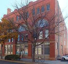
Montgomery Ward Building |
|
000000001996-12-24-0000December 24, 1996
(#85003697) |
225 N. Main St.
38°16′10″N 104°36′30″W / 38.269444°N 104.608333°W / 38.269444; -104.608333 (Montgomery Ward Building) |
Pueblo |
|
| 35 |
Orman-Adams House |
|
000000001976-07-13-0000July 13, 1976
(#76000567) |
102 W. Orman Ave.
38°15′17″N 104°37′39″W / 38.254722°N 104.6275°W / 38.254722; -104.6275 (Orman-Adams House) |
Pueblo |
|
| 36 |
Pitkin Place Historic District |
|
000000001978-01-31-0000January 31, 1978
(#78000880) |
Southern side of the 300 block of W. Pitkin Pl.
38°15′32″N 104°37′40″W / 38.258889°N 104.627778°W / 38.258889; -104.627778 (Pitkin Place Historic District) |
Pueblo |
|
| 37 |
Frank Pryor House |
|
000000001985-02-08-0000February 8, 1985
(#85000231) |
1325 Greenwood St.
38°16′47″N 104°36′46″W / 38.279722°N 104.612778°W / 38.279722; -104.612778 (Frank Pryor House) |
Pueblo |
|
| 38 |
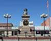
Pueblo Christopher Columbus Monument |
|
000000002011-08-31-0000August 31, 2011
(#11000608) |
Median in 100 block of E. Abriendo Ave.
38°15′34″N 104°37′15″W / 38.259444°N 104.620833°W / 38.259444; -104.620833 (Pueblo Christopher Columbus Monument) |
Pueblo |
|
| 39 |
Pueblo City Park Zoo |
|
000000001995-07-28-0000July 28, 1995
(#95000934) |
3455 Nuckolls Ave.
38°15′43″N 104°39′20″W / 38.261944°N 104.655556°W / 38.261944; -104.655556 (Pueblo City Park Zoo) |
Pueblo |
|
| 40 |
Pueblo County Courthouse |
|
000000001975-06-27-0000June 27, 1975
(#75000534) |
10th and Main Sts.
38°16′36″N 104°36′32″W / 38.276667°N 104.608889°W / 38.276667; -104.608889 (Pueblo County Courthouse) |
Pueblo |
|
| 41 |
Pueblo Federal Building |
|
000000001978-01-03-0000January 3, 1978
(#78000881) |
421 N. Main St.
38°16′16″N 104°36′30″W / 38.271111°N 104.608333°W / 38.271111; -104.608333 (Pueblo Federal Building) |
Pueblo |
|
| 42 |
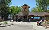
Pueblo Mountain Park |
Upload image |
000000001994-12-06-0000December 6, 1994
(#94001343) |
1 mile south of County Road 220 on S. Pine Dr. (State Route 78) in the San Isabel National Forest
38°02′41″N 105°00′20″W / 38.044722°N 105.005556°W / 38.044722; -105.005556 (Pueblo Mountain Park) |
Beulah |
|
| 43 |
Quaker Flour Mill |
|
000000001976-09-30-0000September 30, 1976
(#76000568) |
102 S. Oneida St.
38°15′45″N 104°36′32″W / 38.2625°N 104.608889°W / 38.2625; -104.608889 (Quaker Flour Mill) |
Pueblo |
|
| 44 |
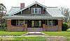
Ward Rice House |
|
000000001985-11-07-0000November 7, 1985
(#85002762) |
1825 Grand Ave.
38°17′03″N 104°36′42″W / 38.284167°N 104.611667°W / 38.284167; -104.611667 (Ward Rice House) |
Pueblo |
|
| 45 |
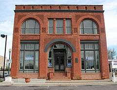
Rood Candy Company Building |
|
000000001984-05-17-0000May 17, 1984
(#84000882) |
408-416 W. 7th St.
38°16′23″N 104°36′43″W / 38.273056°N 104.611944°W / 38.273056; -104.611944 (Rood Candy Company Building) |
Pueblo |
|
| 46 |
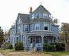
Rosemount |
|
000000001974-07-30-0000July 30, 1974
(#74000592) |
419 W. 14th St.
38°16′49″N 104°36′44″W / 38.280278°N 104.612222°W / 38.280278; -104.612222 (Rosemount) |
Pueblo |
|
| 47 |
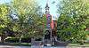
Sacred Heart Church |
|
000000001989-02-21-0000February 21, 1989
(#89000037) |
1025 N. Grand Ave.
38°16′36″N 104°36′42″W / 38.276667°N 104.611667°W / 38.276667; -104.611667 (Sacred Heart Church) |
Pueblo |
|
| 48 |
Sacred Heart Orphanage |
|
000000001989-03-03-0000March 3, 1989
(#89000038) |
2316 Sprague St.
38°14′27″N 104°38′18″W / 38.240833°N 104.638333°W / 38.240833; -104.638333 (Sacred Heart Orphanage) |
Pueblo |
|
| 49 |
Santa Fe Avenue Bridge |
|
000000002002-10-15-0000October 15, 2002
(#02001149) |
U.S. Highway 50 at milepost 1.33
38°15′15″N 104°36′23″W / 38.254167°N 104.606389°W / 38.254167; -104.606389 (Santa Fe Avenue Bridge) |
Pueblo |
|
| 50 |
Squirrel Creek Recreational Unit |
Upload image |
000000002005-03-28-0000March 28, 2005
(#05000215) |
San Isabel National Forest
38°03′03″N 105°02′24″W / 38.050833°N 105.04°W / 38.050833; -105.04 (Squirrel Creek Recreational Unit) |
Beulah |
|
| 51 |
St. Charles Bridge |
|
000000001985-02-04-0000February 4, 1985
(#85000228) |
County Road 65
38°12′03″N 104°32′46″W / 38.200833°N 104.546111°W / 38.200833; -104.546111 (St. Charles Bridge) |
Pueblo |
|
| 52 |
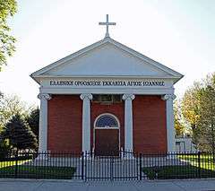
St. John's Greek Orthodox Church |
|
000000002002-02-28-0000February 28, 2002
(#02000123) |
1000-1010 Spruce St.
38°14′58″N 104°37′00″W / 38.249444°N 104.616667°W / 38.249444; -104.616667 (St. John's Greek Orthodox Church) |
Pueblo |
|
| 53 |
Star Journal Model Home |
|
000000001984-02-16-0000February 16, 1984
(#84000886) |
2920 High St.
38°17′55″N 104°37′33″W / 38.298611°N 104.625833°W / 38.298611; -104.625833 (Star Journal Model Home) |
Pueblo |
|
| 54 |
Charles H. Stickney House |
|
000000001985-02-08-0000February 8, 1985
(#85000232) |
101 E. Orman Ave.
38°15′16″N 104°37′36″W / 38.254444°N 104.626667°W / 38.254444; -104.626667 (Charles H. Stickney House) |
Pueblo |
|
| 55 |
J.L. Streit House |
|
000000001984-09-20-0000September 20, 1984
(#84000892) |
2201 Grand Ave.
38°17′19″N 104°36′42″W / 38.288611°N 104.611667°W / 38.288611; -104.611667 (J.L. Streit House) |
Pueblo |
|
| 56 |
Temple Emanuel |
|
000000001996-03-14-0000March 14, 1996
(#96000273) |
1325 N. Grand Ave.
38°16′47″N 104°36′41″W / 38.279722°N 104.611389°W / 38.279722; -104.611389 (Temple Emanuel) |
Pueblo |
|
| 57 |
Tooke-Nuckolls House |
|
000000001985-11-07-0000November 7, 1985
(#85002763) |
38 Carlile Pl.
38°16′10″N 104°37′45″W / 38.269444°N 104.629167°W / 38.269444; -104.629167 (Tooke-Nuckolls House) |
Pueblo |
|
| 58 |
Tutt Building |
Upload image |
000000001983-08-18-0000August 18, 1983
(#83001331) |
421 Central Plaza
38°16′07″N 104°36′29″W / 38.268611°N 104.608056°W / 38.268611; -104.608056 (Tutt Building) |
Pueblo |
|
| 59 |
Union Avenue Historic Commercial District |
|
000000001982-12-28-0000December 28, 1982
(#82001021) |
Roughly bounded by railroad tracks, Main St., Grand and Victoria Aves.
38°15′51″N 104°36′48″W / 38.264167°N 104.613333°W / 38.264167; -104.613333 (Union Avenue Historic Commercial District) |
Pueblo |
|
| 60 |
Union Depot |
|
000000001975-04-01-0000April 1, 1975
(#75000535) |
Victoria and B Sts.
38°15′46″N 104°36′59″W / 38.262778°N 104.616389°W / 38.262778; -104.616389 (Union Depot) |
Pueblo |
|
| 61 |
Vail Hotel |
|
000000001978-12-18-0000December 18, 1978
(#78000882) |
217 S. Grand Ave.
38°15′59″N 104°37′18″W / 38.266389°N 104.621667°W / 38.266389; -104.621667 (Vail Hotel) |
Pueblo |
|
| 62 |
Martin Walter House |
|
000000001984-05-17-0000May 17, 1984
(#84000894) |
300 W. Abriendo Ave.
38°15′42″N 104°37′25″W / 38.261667°N 104.623611°W / 38.261667; -104.623611 (Martin Walter House) |
Pueblo |
|
| 63 |
Asbury White House |
|
000000001984-10-11-0000October 11, 1984
(#84000025) |
417 W. 11th St.
38°16′38″N 104°36′42″W / 38.277222°N 104.611667°W / 38.277222; -104.611667 (Asbury White House) |
Pueblo |
|
| 64 |
Young Women's Christian Association |
|
000000001980-03-24-0000March 24, 1980
(#80000921) |
801 N. Santa Fe Ave.
38°16′28″N 104°36′24″W / 38.274444°N 104.606667°W / 38.274444; -104.606667 (Young Women's Christian Association) |
Pueblo |
|


.JPG)


.JPG)


.JPG)


.JPG)


.JPG)


.JPG)
.JPG)
