National Register of Historic Places listings in Rio Blanco County, Colorado
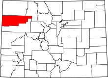
Location of Rio Blanco County in Colorado
This is a list of the National Register of Historic Places listings in Rio Blanco County, Colorado.
This is intended to be a complete list of the properties and districts on the National Register of Historic Places in Rio Blanco County, Colorado, United States. The locations of National Register properties and districts for which the latitude and longitude coordinates are included below, may be seen in a map.[1]
There are 12 properties and districts listed on the National Register in the county. Another property was once listed but has been removed.
- This National Park Service list is complete through NPS recent listings posted December 16, 2016.[2]
| Adams - Alamosa - Arapahoe - Archuleta - Baca - Bent - Boulder - Broomfield - Chaffee - Cheyenne - Clear Creek - Conejos - Costilla - Crowley - Custer - Delta - Denver - Dolores - Douglas - Eagle - El Paso - Elbert - Fremont - Garfield - Gilpin - Grand - Gunnison - Hinsdale - Huerfano - Jackson - Jefferson - Kiowa - Kit Carson - La Plata - Lake - Larimer - Las Animas - Lincoln - Logan - Mesa - Mineral - Moffat - Montezuma - Montrose - Morgan - Otero - Ouray - Park - Phillips - Pitkin - Prowers - Pueblo - Rio Blanco - Rio Grande - Routt - Saguache - San Juan - San Miguel - Sedgwick - Summit - Teller - Washington - Weld - Yuma |
Current listings
| [3] | Name on the Register[4] | Image | Date listed[5] | Location | City or town | Description |
|---|---|---|---|---|---|---|
| 1 | Battle of Milk River Site | 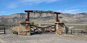 |
(#75000536) |
Address Restricted |
Meeker | Site of the Battle of Milk Creek |
| 2 | Canon Pintado |  |
(#75000538) |
Address Restricted |
Rangely | |
| 3 | Carrot Men Pictograph Site |  |
(#75000539) |
Address Restricted |
Rangely | |
| 4 | Coal Creek School | Upload image | (#14000421) |
617 County Road 6 40°01′52″N 107°49′02″W / 40.0311°N 107.8172°W |
Meeker | |
| 5 | Collage Shelter Site | 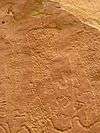 |
(#80000924) |
Address Restricted |
Rangely | |
| 6 | Duck Creek Wickiup Village | Upload image | (#75000537) |
Address Restricted |
Meeker | |
| 7 | Fremont Lookout Fortification Site |  |
(#74000593) |
Address Restricted |
Rangely | |
| 8 | Hay's Ranch Bridge | 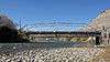 |
(#85000233) |
County Road 127 40°00′48″N 108°05′32″W / 40.013333°N 108.092222°W |
Meeker | |
| 9 | Hotel Meeker |  |
(#80000923) |
560 Main St. 40°02′14″N 107°54′45″W / 40.037222°N 107.9125°W |
Meeker | |
| 10 | Meeker I.O.O.F. Lodge-Valentine Lodge No. 47 | Upload image | (#14000060) |
400 Main St. 40°02′15″N 107°54′40″W / 40.037616°N 107.911095°W |
Meeker | |
| 11 | Pyramid Guard Station | Upload image | (#07001354) |
County Road 8 40°09′10″N 107°13′26″W / 40.152778°N 107.223889°W |
Yampa | |
| 12 | St. James Episcopal Church | .JPG) |
(#78000883) |
368 4th St. 40°02′19″N 107°54′37″W / 40.038611°N 107.910278°W |
Meeker |
Former listing
| [3] | Name on the Register | Image | Date listed | Date removed | Location | City or town | Summary |
|---|---|---|---|---|---|---|---|
| 1 | Whiskey Creek Trestle | 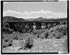 |
(#80000925) | West of Rangely |
Rangely |
See also
| Wikimedia Commons has media related to National Register of Historic Places in Rio Blanco County, Colorado. |
- List of National Historic Landmarks in Colorado
- National Register of Historic Places listings in Colorado
References
- ↑ The latitude and longitude information provided in this table was derived originally from the National Register Information System, which has been found to be fairly accurate for about 99% of listings. For about 1% of NRIS original coordinates, experience has shown that one or both coordinates are typos or otherwise extremely far off; some corrections may have been made. A more subtle problem causes many locations to be off by up to 150 yards, depending on location in the country: most NRIS coordinates were derived from tracing out latitude and longitudes off of USGS topographical quadrant maps created under the North American Datum of 1927, which differs from the current, highly accurate WGS84 GPS system used by most on-line maps. Chicago is about right, but NRIS longitudes in Washington are higher by about 4.5 seconds, and are lower by about 2.0 seconds in Maine. Latitudes differ by about 1.0 second in Florida. Some locations in this table may have been corrected to current GPS standards.
- ↑ "National Register of Historic Places: Weekly List Actions". National Park Service, United States Department of the Interior. Retrieved on December 16, 2016.
- 1 2 Numbers represent an ordering by significant words. Various colorings, defined here, differentiate National Historic Landmarks and historic districts from other NRHP buildings, structures, sites or objects.
- ↑ National Park Service (2010-07-09). "National Register Information System". National Register of Historic Places. National Park Service.
- ↑ The eight-digit number below each date is the number assigned to each location in the National Register Information System database, which can be viewed by clicking the number.
| Topics | |
|---|---|
| Lists by states |
|
| Lists by insular areas | |
| Lists by associated states | |
| Other areas | |
| |
Municipalities and communities of Rio Blanco County, Colorado, United States | ||
|---|---|---|
| Towns | | |
| Unincorporated community | ||
This article is issued from Wikipedia - version of the 2/28/2016. The text is available under the Creative Commons Attribution/Share Alike but additional terms may apply for the media files.