National Register of Historic Places listings in Kane County, Utah
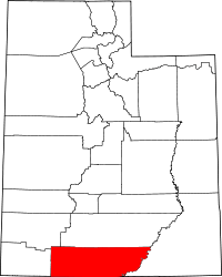
Location of Kane County in Utah
This is a list of the National Register of Historic Places listings in Kane County, Utah.
This is intended to be a complete list of the properties and districts on the National Register of Historic Places in Kane County, Utah, United States. Latitude and longitude coordinates are provided for many National Register properties and districts; these locations may be seen together in a map.[1]
There are 18 properties listed on the National Register in the county.
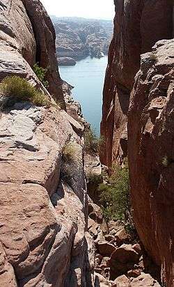
- This National Park Service list is complete through NPS recent listings posted December 2, 2016.[2]
Current listings
| [3] |
Name on the Register[4] |
Image |
Date listed[5] |
Location |
City or town |
Description |
|---|
| 1 |
Bowman-Chamberlain House |
|
000000001975-07-08-0000July 8, 1975
(#75001811) |
14 E. 100 South
37°02′47″N 112°31′37″W / 37.046389°N 112.526944°W / 37.046389; -112.526944 (Bowman-Chamberlain House) |
Kanab |
|
| 2 |
Cottonwood Canyon Cliff Dwelling |
|
000000001980-08-18-0000August 18, 1980
(#80003910) |
Address Restricted[6]
|
Kanab |
|
| 3 |
Davis Gulch Pictograph Panel |
|
000000001975-06-05-0000June 5, 1975
(#75000166) |
Address Restricted[6]
|
Glen Canyon |
|
| 4 |
Maynard and Edith Hamlin Dixon House and Studio |
|
000000002002-01-11-0000January 11, 2002
(#01001450) |
State Route 89
37°15′13″N 112°39′37″W / 37.253611°N 112.660278°W / 37.253611; -112.660278 (Maynard and Edith Hamlin Dixon House and Studio) |
Mt. Carmel Junction |
|
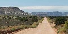
| 5 |
Hole-In-The-Rock |
|
000000001975-11-03-0000November 3, 1975
(#75000165) |
Southeast of Escalante in Glen Canyon National Recreation Area
37°15′31″N 110°54′00″W / 37.258611°N 110.9°W / 37.258611; -110.9 (Hole-In-The-Rock) |
Escalante |
|
| 6 |
Hole-in-the-Rock Trail |
|
000000001982-08-09-0000August 9, 1982
(#82004792) |
A trail commencing at Escalante and terminating at Bluff
37°25′18″N 110°39′51″W / 37.421667°N 110.664167°W / 37.421667; -110.664167 (Hole-in-the-Rock Trail) |
Escalante |
Split between Garfield, Kane, and San Juan counties
|
| 7 |
William Derby Johnson, Jr., House |
|
000000002001-04-06-0000April 6, 2001
(#01000315) |
54 S. Main St.
37°02′49″N 112°31′42″W / 37.046944°N 112.528333°W / 37.046944; -112.528333 (William Derby Johnson, Jr., House) |
Kanab |
The Purple Sage Inn Bed and Breakfast is here in 2013.
|
| 8 |
Kanab (Union Pacific) Lodge |
|
000000002003-08-14-0000August 14, 2003
(#03000153) |
86 S. 200 West
37°02′48″N 112°31′57″W / 37.046667°N 112.5325°W / 37.046667; -112.5325 (Kanab (Union Pacific) Lodge) |
Kanab |
Former home of the Wok Inn, the building seemed deserted in 2013.
|
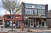
| 9 |
Kanab Hotel and Cafe |
|
000000002003-08-14-0000August 14, 2003
(#03000152) |
19 W. Center St.
37°02′52″N 112°31′42″W / 37.047778°N 112.528333°W / 37.047778; -112.528333 (Kanab Hotel and Cafe) |
Kanab |
|
| 10 |
Kanab Library |
Upload image |
000000001995-09-07-0000September 7, 1995
(#95001067) |
6 S. 100 East
37°02′53″N 112°31′33″W / 37.047917°N 112.525833°W / 37.047917; -112.525833 (Kanab Library) |
Kanab |
|
| 11 |
Kanab Post Office |
|
000000002011-01-24-0000January 24, 2011
(#10001175) |
22 N. Main St.
37°02′55″N 112°31′43″W / 37.048611°N 112.528611°W / 37.048611; -112.528611 (Kanab Post Office) |
Kanab |
Kanab, Utah MPS
|
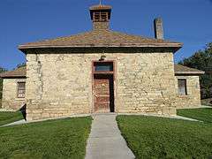
| 12 |
Mt. Carmel School and Church |
|
000000001987-11-20-0000November 20, 1987
(#87002061) |
Off State Route 89
37°14′48″N 112°39′55″W / 37.246667°N 112.665278°W / 37.246667; -112.665278 (Mt. Carmel School and Church) |
Mt. Carmel Junction |
|
| 13 |
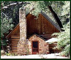
Parry Lodge |
|
000000002003-08-14-0000August 14, 2003
(#02001734) |
89 E. Center St.
37°02′54″N 112°31′34″W / 37.048333°N 112.526111°W / 37.048333; -112.526111 (Parry Lodge) |
Kanab |
|
| 14 |
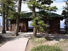
Rainbow Point Comfort Station and Overlook Shelter |
|
000000001995-04-25-0000April 25, 1995
(#95000427) |
Bryce Canyon National Park
37°28′31″N 112°14′21″W / 37.475278°N 112.239167°W / 37.475278; -112.239167 (Rainbow Point Comfort Station and Overlook Shelter) |
Bryce Canyon National Park |
|
| 15 |
Rider-Pugh House |
|
000000002001-04-06-0000April 6, 2001
(#01000316) |
17 W. 100 South
37°02′49″N 112°31′42″W / 37.046944°N 112.528333°W / 37.046944; -112.528333 (Rider-Pugh House) |
Kanab |
|
| 16 |
Riggs Spring Fire Trail |
Upload image |
000000001995-04-25-0000April 25, 1995
(#95000431) |
Bryce Canyon National Park
37°27′47″N 112°14′15″W / 37.463056°N 112.2375°W / 37.463056; -112.2375 (Riggs Spring Fire Trail) |
Bryce Canyon National Park |
|
| 17 |
Stewart-Woolley House |
|
000000002001-04-06-0000April 6, 2001
(#01000314) |
106 W. 100 North
37°03′00″N 112°31′49″W / 37.05°N 112.530278°W / 37.05; -112.530278 (Stewart-Woolley House) |
Kanab |
|
| 18 |
Valley School |
Upload image |
000000001985-04-01-0000April 1, 1985
(#85000807) |
150 N. Main St.
37°16′45″N 112°38′18″W / 37.279167°N 112.638333°W / 37.279167; -112.638333 (Valley School) |
Orderville |
|
See also
References
- ↑ The latitude and longitude information provided in this table was derived originally from the National Register Information System, which has been found to be fairly accurate for about 99% of listings. For about 1% of NRIS original coordinates, experience has shown that one or both coordinates are typos or otherwise extremely far off; some corrections may have been made. A more subtle problem causes many locations to be off by up to 150 yards, depending on location in the country: most NRIS coordinates were derived from tracing out latitude and longitudes off of USGS topographical quadrant maps created under the North American Datum of 1927, which differs from the current, highly accurate WGS84 GPS system used by most on-line maps. Chicago is about right, but NRIS longitudes in Washington are higher by about 4.5 seconds, and are lower by about 2.0 seconds in Maine. Latitudes differ by about 1.0 second in Florida. Some locations in this table may have been corrected to current GPS standards.
- ↑ "National Register of Historic Places: Weekly List Actions". National Park Service, United States Department of the Interior. Retrieved on December 2, 2016.
- ↑ Numbers represent an ordering by significant words. Various colorings, defined here, differentiate National Historic Landmarks and historic districts from other NRHP buildings, structures, sites or objects.
- ↑ National Park Service (2008-04-24). "National Register Information System". National Register of Historic Places. National Park Service.
- ↑ The eight-digit number below each date is the number assigned to each location in the National Register Information System database, which can be viewed by clicking the number.
- 1 2 Some listings on the NRHP are highly sensitive sites and may be subject to looting or vandalism. The NRHP lists this site as "Address Restricted."
External links
 Media related to National Register of Historic Places in Kane County, Utah at Wikimedia Commons
|
|---|
|
| Topics | |
|---|
|
| Lists by states | |
|---|
|
| Lists by insular areas | |
|---|
|
| Lists by associated states | |
|---|
|
| Other areas | |
|---|
|
-
 Portal Portal
-
 WikiProject WikiProject
|
.jpg)
.jpg)
.jpg)

.jpg)
.jpg)
.jpg)