Quarndon
| Quarndon | |
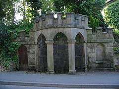
 Spring Well at the Chalybeate Wellhouse, Quarndon[1][2] |
|
.jpg) Public footpaths and mixed pasture and wooded hills such as that pictured above in Quarndon reflect the parish's main 'green space' land use category. |
|
 Quarndon |
|
| Area | 4.49 km2 (1.73 sq mi) |
|---|---|
| Population | 933 (2011 census)[3] |
| – density | 208/km2 (540/sq mi) |
| OS grid reference | SK334410 |
| District | Amber Valley |
| Shire county | Derbyshire |
| Region | East Midlands |
| Country | England |
| Sovereign state | United Kingdom |
| Post town | DERBY |
| Postcode district | DE22 |
| Police | Derbyshire |
| Fire | Derbyshire |
| Ambulance | East Midlands |
| EU Parliament | East Midlands |
|
|
Coordinates: 52°57′58″N 1°30′11″W / 52.966°N 1.503°W
Quarndon ![]() i/ˈkwɔːrn.dən/ is a linear village in the south of the Amber Valley District of Derbyshire, England.
It is spread along four minor upland roads, approximately 1 mile north of the Derby suburb of Allestree, two of which lead towards the city.
i/ˈkwɔːrn.dən/ is a linear village in the south of the Amber Valley District of Derbyshire, England.
It is spread along four minor upland roads, approximately 1 mile north of the Derby suburb of Allestree, two of which lead towards the city.
Many tourists throughout the 18th and early 19th centuries visited Quarndon's chalybeate springs within and next to its wellhouse. Many of these also sampled the waters of a geologically related spring in the grounds of its western neighbour, Kedleston Park and Hall, Kedleston – a village with a smaller population due to its few roads and single land-dominating estate which was once its manor. The lords of that manor equally held lands here and were significant patrons of the church, the early 19th century free school founded here and funded the construction of the village hall.
Amenities
Education
The Curzon CE (Aided) Primary School is in Quarndon which is mostly funded by the local authority, as is Quarndon Pre-School which receives a proportion of funding form Derbyshire County Council and is in the remainder privately funded.[4]
Community
Quarndon has a Church of England church built 1872–74, designed by Giles and Brookhouse in a stone mid-13th century style. The church has informal regular community involvement – it hosts clubs for children and their carers and wide-reaching coffee and cake, exploration of life meetings. The minister in Quarndon is Rev. William Bates.[5][6]
Quarndon Village Hall was built by the Curzon family (assisted with funds raised by village efforts) and opened on 9 May 1914. In 1965, the Hall was extended with an enlarged stage. It was extended again in 2004.[7]
Sports

Quarndon's westernmost area is part of 18-hole Kedleston Park Golf Club.[8]
Quarndon Cricket Club has a ground with parkland, benches, pavilion and in the summer a marquee. Four adult men's sides compete, junior and women's sides also compete against other Derbyshire villages and urban communities.
Drama
Quarndon has an amateur dramatics society which has been performing plays in the village hall since 1941.
Heritage sites
Heritage Lottery funding fully funded a brief wide-ranging history of Quarndon to be researched, distributed and electronically published. The conservation areas and sulphurous well draw visitors and the history, including the architectural history of the church is available in the village as guidebooks.[7]

Millennium Topograph on Bunkers Hill
52°58′8″N 1°29′36″W / 52.96889°N 1.49333°W
This directional compass, provides details of bearings, distances, elevations and dates of nearly 50 places of special interest and was unveiled on 29 September 2001. It stands on an 8-ton block of Derbyshire gritstone – 140 metres above sea level – funded by the will of the third Viscount Scarsdale who died in 2000 aged 76.
Geography
Quarndon has elevations ranging from 75 metres above sea level to 144 metres. The lowest point is at the end of a projection to the south, following Markeaton Brook, which rises at two sources, one in the village and the other from above the lake of Kedleston Park, a large landscape garden in the neighbouring parish to the west. The highest part, Quarndon Hill is a partly settled ridge of mixed woodland and common land topped by a gently winding street leading north-west. The vast majority of the village's buildings are residential, which spread along four minor upland roads north of the City of Derby's suburb of Allestree, two of which lead towards the city.
History
A holding (manor) of Quarndon appears in the Domesday Book of 1086. This survey recorded 8 ploughlands having been held in 1066 by King Edward contemporaneously by William the Conqueror who was also tenant-in-chief.
An ivy-clad bell tower mark the remains of the Norman chapel which served the community's spiritual, marriages, funereal and administrative (vestry) needs until 1874. In the 1870s the village was created an ecclesiastical parish in 1732 converting the small and crumbling chapel to a church and had its forerunner replacement on the present site in 1790.[9]
Starting with a digression to the neighbouring house and park reflective of his landed class, Daniel Defoe wrote in the early 18th century:
In our way we past an [ancient][10] seat [Kedleston Hall], large, but not very [ornate],[11] of Sir Nathaniel Curson, a noted and (for wealth) over great family, for many ages inhabitants of this county. Hence we kept the Derwent on our right-hand, but kept our distance, the waters being out; for the Derwent is a frightful creature when the hills load her current with water; I say, we kept our distance, and contented our selves with hearing the roaring of its waters, till we came to Quarn or Quarden. a little ragged, but noted village, where there is a famous chalybeat spring, to which abundance of people go in the season to drink the water, as also a cold bath.— Daniel Defoe, 1720s[12]
A brief extract of a large Victorian geographical, historic and economic Topographical Dictionary reads:
It comprises 790 acres (3.2 km2)...619 grass-land, 160½ ploughland and gardens, and 10 acres plantations...The soil in the lower part is a very rich marl, and in the higher a light dry sandy soil...the surface is undulated, and the scenery picturesque. The village, which is scattered, is considerable, being nearly a mile and a half in length; it is of pleasant appearance, and contains some very neat modern houses...church is an ancient structure, with a campanile tower nearly covered with ivy, and a Norman arch at the entrance. Sir John Curzon, in 1725, bequeathed an annuity of £20 for the support of a free school. In the village is a chalybeate spring, which was much resorted to upwards of a century since, and is still visited in summer, the water being highly beneficial in cases of debility.
The church cost just over £4,000 (equivalent to £322,000 in 2015) to build. Its land together with a contribution of £1,000 was given by the Rev'd Alfred Curzon, 4th Baron Scarsdale. Its skeleton clock was installed in 1897 to mark Queen Victoria's Diamond Jubilee.
Demography
| Output area | Homes owned outright | Owned with a loan | Socially rented | Privately rented | Other | km² green spaces | km² roads | km² water | km² domestic gardens | km² domestic buildings | km² non-domestic buildings | Usual residents | km² |
|---|---|---|---|---|---|---|---|---|---|---|---|---|---|
| Quarndon | 386 | 415 | 23 | 99 | 10 | 4.06 | 0.06 | 0.01 | 0.38 | 0.05 | 0.01 | 933 | 4.49 |
Notable people

- Bertie Banks who was T. E. Lawrence's driver during World War I
- Brian Clough, football manager and player
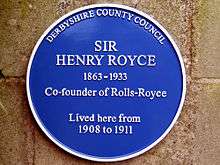
- Sir Henry Royce, a plaque was erected on the gate pillar of Quarndon House to commemorate Royce's residency in the village from 1908 to 1911, a time when Rolls-Royce's Nightingale Road factory had just opened.
References
- ↑ This ornate spring/wellhouse is Grade II listed. A plaque inside the well has the following description "17th century chalybeate spring well. Once famous spa noted for medicinal waters containing iron. Visited by Daniel Defoe in 1727".
- ↑ Historic England. "Details from listed building database (1311372)". National Heritage List for England.
- 1 2 Key Statistics: Dwellings; Quick Statistics: Population Density; Physical Environment: Land Use Survey 2005
- ↑ Derbyshire County Council – School Details. Retrieved 17 February 2015
- ↑ Quarndon St Paul The Church of England. Retrieved 17 February 2015
- ↑ Historic England. "Details from listed building database (1109102)". National Heritage List for England.
- 1 2 Extract from A Brief History of Quarndon Quarndon Parish Council. Retrieved 17 February 2015.
- ↑ Kedleston Park Golf Course. Retrieved 17 February 2015
- ↑ Vision of Britain University of Portsmouth and others. Retrieved 17 February 2015
- ↑ Archaism: antient
- ↑ Archaism: gay with respect to style of architecture
- ↑ Daniel Defoe, (c1724) A tour thro' the whole island of Great Britain, divided into circuits or journies: Letter 8, Part 2: The Peak District, Reprnted: London: JM Dent and Co, 1927
- ↑ Samuel Lewis's Topographical Dictionary, 1848, pages 623–4
External links
| Wikimedia Commons has media related to Quarndon. |
- Brief description
- GENUKI page
- 20 photographs of the village
- Quarndon Parish Council and village news
- Local Heritage Initiative
- Quarndon Amateur Dramatic Society