Shōwa-ku, Nagoya
| Shōwa 昭和区 | |
|---|---|
| Ward | |
| Shōwa Ward | |
|
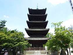
Kōshō-ji | |
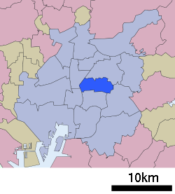 Location of Shōwa-ku in Nagoya | |
 Shōwa
| |
| Coordinates: 35°09′01″N 136°56′03″E / 35.15028°N 136.93417°ECoordinates: 35°09′01″N 136°56′03″E / 35.15028°N 136.93417°E | |
| Country | Japan |
| Region |
Tōkai region Chūbu region |
| Prefecture | Aichi |
| Area | |
| • Total | 10.94 km2 (4.22 sq mi) |
| Population (November 2011) | |
| • Total | 105,360 |
| • Density | 9,630/km2 (24,900/sq mi) |
| Time zone | Japan Standard Time (UTC+9) |
| - Tree | Flowering Dogwood [1] |
| - Flower | Japanese iris [1] |
| Phone number | 052-731-1511 |
| Address | 3-19, Yuwa-dori, Showa-ku, Nagoya-shi, Aichi-ken 466-8585 |
| Website |
www |
Shōwa-ku (昭和区 Shōwa-ku) is one of the 16 wards of the city of Nagoya in Aichi Prefecture, Japan. As of 2011, the ward had an estimated population of 105,360 and a population density of 9,630 persons per km². The total area was 10.94 km².
Geography
Shōwa Ward is located near the geographic center of Nagoya.
Surrounding municipalities
History
Gokiso Village in Aichi District was annexed by Nagoya on August 22, 1921, becoming part of Naka District. Shōwa District was established on October 1, 1937 out of a portion of former Naka District and Minami District. On Feb 11, 1944, a portion of Shōwa District joined with a portion of Atsuta District to form Mizuho District. On April 5, 1955 the district annexed neighboring Tempaku village, which became the separate Tempaku District on February 1, 1977.
Education
- Chukyo University
- Nagoya University – Medical School
- Nagoya Institute of Technology
- Nanzan University
- St. Mary's College, Nagoya
- Kuwayama Art Museum
- Mandolin Melodies Museum
- Showa Museum of Art
- Tsuruma Central Library
Transportation
Railroads
- Nagoya Municipal Subway – Tsurumai Line
- Nagoya Municipal Subway – Sakura-dōri Line
- Nagoya Municipal Subway – Meijō Line
Highways
Local attractions
Noted people from Shōwa Ward, Nagoya
- Sakuma Morimasa – samurai
- Karina Nose – actress, model
References
- 1 2 昭和(しょうわ)区の紹介 (in Japanese). Nagoya City. 27 January 2009.
External links
![]() Media related to Shōwa-ku, Nagoya at Wikimedia Commons
Media related to Shōwa-ku, Nagoya at Wikimedia Commons
| Wards of Nagoya | ||
|---|---|---|
| Core cities | ||
| Special cities | ||
| Cities | ||
| Aichi District | ||
| Ama District | ||
| Chita District | ||
| Kitashitara District | ||
| Nishikasugai District | ||
| Niwa District | ||
| Nukata District | ||