Ōharu, Aichi
| Ōharu 大治町 | |||
|---|---|---|---|
| Town | |||
|
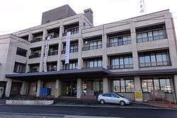
Ōharu Town hall | |||
| |||
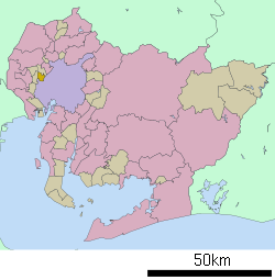 Location of Ōharu in Aichi Prefecture | |||
 Ōharu
| |||
| Coordinates: 35°10′30.2″N 136°49′12.3″E / 35.175056°N 136.820083°ECoordinates: 35°10′30.2″N 136°49′12.3″E / 35.175056°N 136.820083°E | |||
| Country | Japan | ||
| Region |
Chūbu region Tōkai region | ||
| Prefecture | Aichi Prefecture | ||
| District | Ama | ||
| Area | |||
| • Total | 6.59 km2 (2.54 sq mi) | ||
| Population (May 2015) | |||
| • Total | 31,226 | ||
| • Density | 4,740/km2 (12,300/sq mi) | ||
| Time zone | Japan Standard Time (UTC+9) | ||
| - Tree | Chinaberry | ||
| - Flower | Satsuki azalea | ||
| Phone number | 052 (444) 2711 | ||
| Address | 1-1 Daimon-Nishi, Ōharu-chō, Ama-gun, Aichi-ken 490-1192 | ||
| Website | Official website | ||


Ōharu (大治町 Ōharu-chō) is a town located in Ama District, Aichi Prefecture, Japan. As of May 2015, the town had an estimated population of 31,226 and a population density of 4740 persons per km². The total area was 6.59 square kilometres (2.54 sq mi).
Geography
Ōharu is located in western Aichi Prefecture.
Neighboring municipalities
- Aichi Prefecture
History
Ōharu Village was established in 1889. It was raised to town status in 1975. In 2008, discussions were held to merge Ōharu with neighboring Shippō, Jimokuji and Miwa towns. The latter three municipalities formed the new city of Ama, but Ōharu withdrew from the negotiations, and remains an independent municipality.
Education
Ōharu has three elementary and one middle school.
Transportation
Railway
Ōharu is not served by any passenger rail transport. The nearest train station is Nakamura Kōen on the Nagoya Municipal Subway’s Higashiyama Line in neighboring Nakamura-ku, Nagoya.
Highway
- Nagoya Dai-Ni Kanjo Expressway
External links
![]() Media related to Ōharu, Aichi at Wikimedia Commons
Media related to Ōharu, Aichi at Wikimedia Commons
- Official website (Japanese)
| Wards of Nagoya | ||
|---|---|---|
| Core cities | ||
| Special cities | ||
| Cities | ||
| Aichi District | ||
| Ama District | ||
| Chita District | ||
| Kitashitara District | ||
| Nishikasugai District | ||
| Niwa District | ||
| Nukata District | ||