Takahama, Aichi
| Takahama 高浜市 | |||
|---|---|---|---|
| City | |||
|
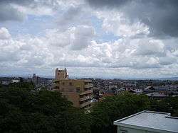
View of Takayama City from Oyama Park | |||
| |||
 Location of Takahama in Aichi Prefecture | |||
 Takahama
| |||
| Coordinates: 34°55′39″N 136°59′16″E / 34.92750°N 136.98778°ECoordinates: 34°55′39″N 136°59′16″E / 34.92750°N 136.98778°E | |||
| Country | Japan | ||
| Region | Chūbu (Tōkai) | ||
| Prefecture | Aichi Prefecture | ||
| Government | |||
| Area | |||
| • Total | 13.00 km2 (5.02 sq mi) | ||
| Population (February 2012) | |||
| • Total | 44,723 | ||
| • Density | 3,440/km2 (8,900/sq mi) | ||
| Time zone | Japan Standard Time (UTC+9) | ||
| - Tree | Cinnamomum camphora | ||
| - Flower | Chrysanthemum | ||
| Phone number | 0566-52-1111 | ||
| Address | Aoki-chō, Tahakama-shi, Aichi-ken 444-1398 | ||
| Website | City of Takahama | ||


Takahama City Hall
Takahama (高浜市 Takahama-shi) is a city located in central Aichi Prefecture, Japan.
As of February 2012, the city has an estimated population of 44,723 and a population density of 3,440 persons per km². The total area was 13.00 km².
Geography
Takahama is situated in south-central Aichi Prefecture.
Neighboring municipalities
History
Takahama Village was created within Hekikai District on October 1, 1889. It was raised to town status on July 9, 1900, and annexed neighboring Yoshihama and Takatori villages on May 1, 1906. Takahama was raised to city status on December 1, 1970, at which time Hekikai District ceased to exist.
Transportation
Rail
Highways
External links
| Wikimedia Commons has media related to Takahama, Aichi. |
- Takahama City official website (Japanese)
| Wards of Nagoya | ||
|---|---|---|
| Core cities | ||
| Special cities | ||
| Cities | ||
| Aichi District | ||
| Ama District | ||
| Chita District | ||
| Kitashitara District | ||
| Nishikasugai District | ||
| Niwa District | ||
| Nukata District | ||
This article is issued from Wikipedia - version of the 10/23/2016. The text is available under the Creative Commons Attribution/Share Alike but additional terms may apply for the media files.