Shire of Bridgetown-Greenbushes
This article is about a local government area. For the town, see Bridgetown, Western Australia.
| Shire of Bridgetown Greenbushes Western Australia | |||||||||||||
|---|---|---|---|---|---|---|---|---|---|---|---|---|---|
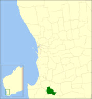 Location in Western Australia | |||||||||||||
| Population | 4,513 (2013 est)[1] | ||||||||||||
| • Density | 3.3684/km2 (8.7242/sq mi) | ||||||||||||
| Established | 1970 | ||||||||||||
| Area | 1,339.8 km2 (517.3 sq mi) | ||||||||||||
| Mayor | Brian Moore | ||||||||||||
| Council seat | Bridgetown | ||||||||||||
| Region | South West | ||||||||||||
| State electorate(s) | Blackwood-Stirling | ||||||||||||
| Federal Division(s) | O'Connor | ||||||||||||
|
| |||||||||||||
| Website | Shire of Bridgetown Greenbushes | ||||||||||||
| |||||||||||||
The Shire of Bridgetown-Greenbushes is a local government area in the South West region of Western Australia, about 80 kilometres (50 mi) southeast of Bunbury and about 260 kilometres (162 mi) south of the state capital, Perth. The Shire covers an area of 1,340 square kilometres (517 sq mi), and its seat of government is the town of Bridgetown.
History
The Nelson Road Board (renamed to Bridgetown Road Board in 1917) was gazetted in 1887, while the Greenbushes Road Board was gazetted in 1900. On 1 July 1961, they both became shires following changes to the Local Government Act. On 26 March 1970 the two shires were merged.[2]
Wards
The shire is divided into four wards.
- South Ward (seven councillors)
- North Ward (two councillors)
Towns
References
- ↑ "3218.0 Regional Population Growth, Australia. Table 5. Estimated Resident Population, Local Government Areas, Western Australia". 3 April 2014. Retrieved 11 September 2014.
- ↑ WA Electoral Commission, Municipality Boundary Amendments Register (release 2.0), 31 May 2003.
External links
Coordinates: 33°57′29″S 116°08′28″E / 33.958°S 116.141°E
This article is issued from Wikipedia - version of the 11/9/2016. The text is available under the Creative Commons Attribution/Share Alike but additional terms may apply for the media files.